Submitted:
09 September 2025
Posted:
10 September 2025
You are already at the latest version
Abstract
The buffer zone of a historical or cultural heritage is always surrounded the core protected area of the heritage. Currently, there are no mature or universally applicable methods for buffer zones delineation. This study takes a historical and cultural village, the Huitong Village in Zhuhai, Guangdong, as the research area. With the perspective of cultural geography, this study explores a new framework for delineating buffer zones with three steps. This paper proceeds from two points, the integrity of the water system and the mankind shared value of the visual corridors. The conclusions of this study are as follows: 1) This study shows the feasibility of our proposed buffer zone delineation method based on cultural geography. 2) The delineation method of buffer zone in this study can serve as a reference method of value comparison for historical space protecting planning at different scales.
Keywords:
preservation of historical and cultural village
; buffer zone delineation
; cultural geography
; Huitong Village in Zhuhai
1. Introduction
1.1. The Delineation of Cultural Heritage Buffer Zones Urgently Requires Mature Theories and Methods
The term “buffer zone” was first formally introduced by UNESCO in 1977 in The Operational Guidelines for the World Heritage Committee [1], and has been continuously updated in subsequent editions of it [2]. Buffer zone is an expanded area extending beyond the core zone (the heritage site with recognized effective protection boundaries), serving as a supplementary preservation measure. Its functions include mitigating external threats, preserving and enhancing the “Outstanding Universal Value” of heritage sites, etc, playing a crucial role in their preservation, sustainability, and development. Outstanding Universal Value means cultural and/or natural significance which is so exceptional as to transcend national boundaries and to be of common importance for present and future generations of all humanity [2]. Like core zones, buffer zones in historical and cultural preservation areas are used as administrative tools. Their primary purpose is to support core zone preservation efforts, maintaining the authenticity, integrity, and sustainability of heritage regions [3]. The 2008 International Expert Meeting on World Heritage and Buffer Zones addressed buffer zones as a key agenda item. Document No. 25 World Heritage and Buffer Zones emphasized: “For the purposes of effective protection of the nominated property, a buffer zone is an area surrounding the nominated property which has complementary legal and/or customary restrictions placed on its use and development to give an added layer of protection to the property [4]”. After this conference, research on buffer zones has gradually increased.
The academic community currently recognizes the immaturity of buffer zone delineation methods for historical and cultural preservation areas. Scholars such as Wang argue that research on buffer zones for historic districts remains in its infancy, lacking systematic theoretical exploration [5]. Lu and his colleagues highlight the oversimplified and conservative approaches in cultural heritage protection zone delineation, attributing this to insufficient systematic analysis of delineation criteria. They emphasize that buffer zones planning constitutes a multi-layered complex system requiring comprehensive functional structure research [6]. Dong notes that preservation control zones for certain heritage sites exhibit poor specificity, typically expanding outward without precise geographic coordinates, while overlapping zones between different heritage sites persist [7]. Kou et al. further observed that legally approved preservation control zones for protected sites often lack practical applicability and effectiveness, underscoring the urgent need for developing a scientific buffer zone delineation framework [8].
1.2. The Perspective of Cultural Geography in the Buffer Zones' Delineation Methods Has Its Advantages
Article 31 of the Urban and Rural Planning Law of the People's Republic of China stipulates that the protection of famous historical and cultural cities, towns and villages as well as the maintenance and use of protected buildings shall abide by relevant laws, administrative regulations and the provisions of The State Council [9]. The “Purple Line” in China’s territorial spatial planning is closely related to buffer zones, which are legal protection areas established to protect historical and cultural blocks and historical buildings [10]. Compared to designating buffer zones for urban historical preservation areas or protected buildings, delineating buffer zones for rural historical and cultural villages presents greater challenges. This is because of two primary factors. First, urban historical buildings or urban historic districts have distinct and widely recognized cultural significance, and it is easy to delineate buffer zones based on cultural significance; second, urban areas possess more tangible physical elements than rural areas when establishing historical preservation buffer zones. In 1987, the International Council on Monuments and Sites (ICOMOS) issued the Washington Charter to supplement the Venice Charter (1964), International Charter for the preservation and Restoration of Monuments and Sites. The Washington Charter outlines principles, objectives, and methods for preserving historical towns and urban areas, emphasizing that “It also seeks to promote the harmony of both private and community life in these areas and to encourage the preservation of those cultural properties, however modest in scale, that constitute the memory of mankind [11]”. Natural villages are small spatial units where cultural significance and value might have not become part of collective historical memory at the national level or for all mankind, but parts of collective memory at the community level. Therefore, it is necessary to explore the meaning of human empathy in small villages and refer to the meaning of delineating buffer zones.
Cultural geography excels in exploring the cultural significance of places and landscapes, making it well-suited for interdisciplinary efforts in delineating buffer zones for historic villages. The fundamental analytical framework of cultural geography revolves around the “horizontal perspective” and “vertical perspective” [12] to assess heritage integrity and sustainability. The “horizontal perspective” examines how micro-regions and broader contexts convert into each other—particularly the conversion of landscape values between small communities and large communities. The “vertical perspective” follows the concept of cultural landscape proposed by Carl O. Sauer, the founder of cultural geography, which emphasizes the interconnection between natural elements and human-made components [13]. While architecture also addresses this “horizontal perspective” and “vertical perspective” [14], its spatial scope remains confined to architectural elements compared to the whole landscape system emphasized in cultural geography.
2. Research on the Delineation of Buffer Zone for Historical and Cultural Heritage
Given that the purpose of establishing historical and cultural heritage buffer zones is to protect the integrity, authenticity, and sustainability of heritage sites, the literature review adopts the “horizontal perspective” to categorize relevant research into two types. One is “Inward”—the governance objective of buffer zones aims to preserve core areas. The other one is “Outward”—the governance objective of buffer zones seeks to establish connections between core areas and other parts of cities and villages.
2.1. “Inward”—The Research on Buffer Zone Supporting the Protection of Core Area
There are many studies on buffer zones supporting core area protection, and the following cases are some supporting approaches.
First, controlling building heights within buffer zones aims to position the core area as the “figure” in a “figure-ground” relationship. Figure-ground plan is one of the commonest types of images used in urban planning, “Figure” refers to the prominent architecture, while “ground” denotes the surrounding buildings that set off the figure [15]. For instance, Shenyang City, the Imperial Palace, Fuling and Zhaoling Protection Ordinance designates a buffer zone around Shengyang Imperial Palace. The buildings within the buffer zone are restricted to 9-30 meters in height based on their distance from the core area, ensuring the palace complex remains a prominent “figure” rather than being swallowed by modern concrete jungles [16]. Similarly, Iranian scholars propose height controls for the Zandieh Complex and Hafezieh Tomb to preserve their historic skylines [17]. Another example involves scholars requiring height restrictions in the urbanizing area between the World Heritage Sites of Süleymaniye Mosque and Zeyrek Mosque, the ruins of the two Mosques on opposite hills in Istanbul’s Historical Peninsula, to maintain visual communication between these heritage sites. These areas where height needs to be controlled are the buffer zones [18].
Secondly, preserving elements associated with core heritage components aims to safeguard the landscape integrity of the site. Taking Iran’s Anahita Temple as an example, this ancient shrine enshrines Anahita, the Iranian water deity. The temple’s foundation relied on natural spring water within the site and a seasonal river flowing westward from the site. However, the modern development of the city has severed this connection—the spring water has been removed, while the upper reaches of the seasonal river have been developed into an urban water source. Scholars argue that incorporating seasonal river water sources into the temple’s heritage buffer zone would restore this vital relationship [19].
Thirdly, preserving the original architectural character of buffer zones aims to remain the core area as the “figure” in the “figure-ground” relationship. A prime example is the preservation of gray-brick buildings in the buffer zone around The Historic Centre of Macao. It's located near the historic city center and has Chinese communities that once thrived. Its low-lying structures were built predominantly with gray bricks, which are suffering from saltwater infiltration in their foundations due to global climate change and summer typhoons. This makes the brickwork particularly vulnerable, making preservation of these heritage walls a key priority in buffer zone management [20].
Fourthly, protecting related archaeological sites within buffer zones aims to highlight the central role of core area heritage. A prime example is Turkey's Sümela Monastery, a vital cultural site perched on the steep cliffs of the Pontic Mountains, specifically in the Altindere Valley. After the 1923 population exchange between Turkey and Greece, this Orthodox monastery suffered damage and fell into disrepair. Since 2000, it has been prioritized for preservation, while surrounding scattered monastic ruins (including the Monasteries of Vazelon, Panagia Keramesta and Kuştul that historically interacted with Sümela Monastery) have become the primary focus of preservation efforts in the buffer zone. Figure 1 shows the locations of the monasteries interacted with Sümela Monastery [21].
Of course, many heritage buffer zones have adopted a variety of governance approaches. For example, the protection plan for Hailongtun Tusi Fortress in Guizhou Province, China, delineates three types of buffer zones, and the governance contents of each type of buffer zones are different [22].
2.2. “Outward”—The Research on the Buffer Zones Promoting the Transition Between the Core Areas and Other Areas
There are also many studies on how to use buffer zones to promote the transition between core areas and other areas. The following cases are a few of the ways to promote it.
Firstly, defining functions of buildings in buffer zones helps preserve the continuous transition between ancient and modern architecture in a city. A prime example is the protecting design in Braga, Portugal. Braga is known as “the Rome of Portugal”. The historic building complex in its old city forms the core protection area. These buildings span from 14th-century to 18th-century buildings, creating an uninterrupted occupation sequence. Some modern buildings like Braga’s District Archive are inlaid in the buffer zone of the historic building complex. Established in 1937 in an abandoned monastery, the archive now faces limitations of space and facilities that prompted the University of Minho to renovate it. Faculty members from the school of Architecture and Civil Engineering Departments explored a renovation plan for the Braga’s District Archive [23]. It highlights the historical bridging role of the archive, which establishes a smooth temporal transition between the core area and other modern parts of the city.
Secondly, protect the ancient buildings in the buffer zone to protect the integrity of the changes of historical heritages perceived by contemporary communities. A prime example is Iran’s Anahita Temple, originally constructed during the Achaemenid period and expanded through the Parthian period and Sasanian period, bearing Roman-Hellenistic architectural styles. The temple has been preserved through the Islamic era and adapted to the city’s built-up structures, where mosques and a bazaar are embedded around. Through interviews with locals, some researchers found that the “perceptual buffer zone” of locals about the temple encompassed later Islamic cultural elements [19]. This perception-driven approach to buffer zone delineation has been implemented in UNESCO World Heritage preservation programs [24], creating opportunities for contemporary communities to actively participate in the sustainable management and protection of historical sites.
Thirdly, antique design approaches are applied to buffer zones to achieve natural transitions between core areas and modern parts of cities. A prime example is Sarajevo, capital of Bosnia and Herzegovina. To preserve the historic architecture of the Austro-Hungarian era, faculty from the University of Sarajevo’s Architecture Department proposed creating transparent skylights above a centrally enclosed atrium. These skylights incorporate Ottoman-style lattice windows, which are called mušebak. Figure 2 shows the pattern of mušebak and the roof with this pattern. They allow visitors to experience a visual effect akin to gazing at the sky through the lattice windows of historic buildings when standing within such atrium spaces [25].
3. Research Area and Research Methods
3.1. Information About Huitong Village in This Study
The village under study is called Huitong. It is a natural village administered by Huitong Administrative Village in Tangjiawan Town, Xiangzhou District, Zhuhai City, Guangdong Province. China's cities are divided into four levels. They are municipalities, sub-provincial cities, prefecture-level cities, and county-level cities. Zhuhai belongs to the third level. It was first recorded in 1732, the Year of Yongzheng Renzi in the Qing Dynasty, it boasts a history spanning nearly three centuries [26]. The village’s name was after Mr. Yujing Mo’s styled name, which is Huitong. It was because of his financial contributions to the new village construction when Mo’s expanded family moved here with the Bao and Tan families. Huitong Village was recognized as a district-level cultural heritage site in 2006, designated as a Guangdong provincial old village in 2009, certified as a Guangdong provincial traditional village in 2014, then selected to be one of the “Top 10 Beautiful Villages in Guangdong” in 2020 [27]. All these labels solidify its cultural significance.
Many villages in the Pearl River Delta region share common spatial patterns [28,29]. Huitong Village shares four spatial characteristics with numerous villages in this region. First, ancestral halls serve as the core spatial organizing core of residential areas. Second, a pond (or a border river in some villages) is in front of the village, which has the function of flood storage and irrigation. Third, villagers use rammed earth walls for defense. Fourth, villages’ orientations are determined by the Feng Shui Theory. Huitong Village is situated in front of a small hill, which is one of the northern foothills of Fenghuang Mountain. Hence its orientation faces southwest. The Long Pond in front of the village connects to the upstream at Chihua Hill in Fenghuang Mountain range and the downstream Waipukeng (river name), while Hui River forms a semi-circular barrier in front of the village, serving as a natural defense against bandits in the early 20th century. Through our field survey and the historical records, we have reconstructed Huitong Village’s historical appearances from the 1930s, 1960s, and 1980s. Figure 3 is with the marks of some changes (e.g., The Long Pond in front of the village, the village walls, and farmland). Fortunately, the “three streets and eight alleys” layout has remained unchanged, and some old buildings are well-preserved.
3.2. Research Methods
The geographical methodology of this study follows common ground with empirical research approaches across multiple disciplines, which typically involve collecting data, investigating relationships, drawing conclusions, and conducting evaluations. The unique is that geographers focus on exploring spatial relationships using the “horizontal perspective and vertical perspective” framework previously discussed, and cultural geographers emphasize the cultural values embedded within these spatial relationships. Taking architects and geographers as a comparative group, the first step is relatively straightforward for architects and geographers. When collecting data, architects can easily identify detailed elements in buildings and building complexes, such as construction materials and architectural forms; while geographers readily recognize natural elements. When investigating relationships, architects or civil engineers can easily discern aesthetic and mechanical relationships between architectural elements, whereas geographers better understand material-energy interactions between natural elements. In this study, as cultural geographers, we focus on the elements of the landscape system (“vertical perspective”), the relationships of “inward” and “outward” connections (“horizontal perspective”), and the evaluations of the value within the relationships.
Step 1: Identifying elements. First, identify the historical buildings and building complexes to be protected in Huitong Village. Second, search for physical elements related to the protected buildings and building complexes within the village and surrounding areas. The specific operation includes historical data analysis, contemporary literature review, and semi-structured interviews.
Step 2: Exploring relationships. First, identify “inward” connections that highlight the physical components of protected buildings and architectural complexes. Second, seek “outward” connections that facilitate a smooth transition from the core area to modern parts of cities. The specific operation in this step involves the research team continuously switching observation subjects in the field, particularly from the perspective of imagining historical subjects.
Step 3: Conducting evaluations. This constitutes the most crucial phase in cultural geography. It elevates geographical spatial and regional analyses to a conceptual level by addressing the cultural values underlying human activities (including buffer zone delineation for historical villages). Generally, we evaluate the two correlations of “inward” and “outward” analysis for buffer zones from four dimensions: ①Whether the regulations of the historical village buffer zones have enhanced people’s well-being; ② Whether they have promoted social harmony; ③ Whether they have strengthened ecological environmental protection; ④ Whether they have maintained cultural vitality [30]. Evaluations must consider both villagers’ perspectives and the broader community’s interests. In the proposed buffer zone delineation method, researchers give subjective weight to elements to establish a universal delineation criterion of buffer zones. A notable example is the study on Shedian Ancient Town in Henan Province, which analyzes 29 historical preservation plans and statistically aggregates key elements considered in buffer zone delineation, including natural landscapes, agricultural features, architectural characteristics, building quality, floor levels, age of structures, street patterns, historical elements, city context, cultural industries, and cultural component [31]. Distinct from such evaluating method of buffer zones without considering the differences between subjects, this study employs a multi-subject framework with the above four dimensions. Yi-Fu Tuan, a renowned cultural geographer and representative of humanistic geography, proposed a phenomenological approach, that is returning to human nature for understanding key points of empathy among different groups, thereby evaluating relationships between elements [32]. This approach is different from the empirical method, which does not base on the induction and summary of a large amount of data, but emphasizes the reflection on human nature. Chinese architects also highly endorse this methodology [33]. This paper adopts the approach proposed by Tuan to conduct evaluations. The specific operation includes semi-structured interviews.
4. Analysis
4.1. Determine the Spatial Base Points for Delineating the Buffer Zone of Huitong Village
The research team conducted field investigations of cultural heritage buildings and historical building sites (Table 1), which serve as spatial baselines for analysis of integrity, authenticity and sustainability.
4.2. The Adjustment Proposal of the Buffer Zone Boundary Based on Visual Corridors
Visual corridor/view corridor is a spatial passage through which a viewpoint can observe specific scenery. The definition used by China's urban and rural planning administrative departments is a narrow strip between viewpoint and scenic spot where the strip is continuous and unobstructed [34]. The regulation of visual corridor scope also serves as a control mechanism in spatial governance.. A viewpoint refers to the position where an observer gazes at a specific scenery, while the scenery consists of both the observed landscape and its surrounding background [35].
The first step: identifying elements. Through field research, we found many locations in Huitong Village that could serve as components of visual corridors. Since the subject of analysis is a historical village, we also identified two types of viewing subjects: those from history and those from the present.
The second step: exploring relationships. Based on cultural significance derived from the subject's visual perspective, we selected two sceneries. One is Qixiaxian Garden, the other is Beijing Normal University's Hong Kong Baptist International College (Its acronym is UIC). Both are outside the village. The viewpoint for viewing Qixiaxian Garden is the North Watchtower, while the viewpoint for UIC is the midpoint of Zhongheng Street (Figure 4).
The third step: conducting evaluations. The meaning of the visual corridors we refined can become the connotation that people recognize the historical and cultural value of Huitong Village.
First, we evaluate the meaning of the “inward” visual corridor, the view from the North Watchtower to Qixiaxian Garden. (Figure 5) According to the rubbing text of Zheng Gongren's Epitaph written by Dayuan Ou, a renowned educator in the late Qing Dynasty and early Republic of China, the proposal to build two watchtowers in Huitong Village comes from Mrs. Yuxia Zheng, the wife of local resident Yingzou Mo [36]. Gongren is the title for the wife of a third-grade official in ancient China. Yingzou Mo is the grandson of Shiyang Mo. Although he had not been an official in government, his wife still got the title of Gongren after her death. His grandfather was the first comprador at Hong Kong Butterfield & Swire Far East Branch. In 1918, to escape war and banditry, Yingzou Mo planned to relocate his family. Yuxia Zheng worried about that the villagers were unable to evacuate and thought they could not be abandoned, leading Yingzou Mo to change his mind and build two watchtowers in the village for defense. Scholars have highly praised this woman's sense of responsibility towards her community [37]. The construction of Qixiaxian Garden also connects with Yuxia Zheng's. She used this venue as her residence with three self-combed ladies (the women who reject traditional marriage customs). They meditated there together. After passing away in Hong Kong, she was buried at the west side of Qixiaxian Garden [38]. Today, standing at the North Watchtower (Figure 5) and gazing at Qixiaxian Garden, one can recall this compassionate and responsible woman. While other accounts about Qixiaxian Garden exist [39], none have credible historical evidence [40]. More importantly, these alternative narratives fail to reveal anything beyond Yuxia Zheng's personal charisma.
Secondly, we evaluate the meaning of the “outward” visual corridor. Through interviews, we gained insights into how modern residents perceive the UIC buildings from Zhongheng Street. Looking along this street in both directions, what was once village gardens now forms the original visual corridor scenery of an orchard-surrounded settlement. Now, looking to the southeast, the UIC buildings have become the scenery (Figure 6). We initially proposed planting a large tree at the southeast end of Zhongheng Street to block the view of the UIC buildings. However, interviews reveal that residents are pleased with the government’s land acquisition for UIC development, as it significantly boosts both collective village income and individual benefits. Villagers believe the UIC presence makes them feel integrated into urban development rather than isolated as a small village in Fenghuang Mountain. As previously mentioned, buffer zones should support outward-looking objectives. Therefore, we argue that visual corridors showing UIC buildings carry greater positive meaning than those obstructing trees. UNESCO’s Recommendation Concerning the Protection and Contemporary Role of Historic Areas states: “Promote an integrated and harmonious relationship between preservation and new architectural and urban developments in order to preserve the integrity of the historic landscape [41]”. Places should embrace all eras and styles, transforming historical elements into timeless concepts that transcend time [42].
4.3. The Adjustment Proposal of the Buffer Zone Boundary Based on Water System Integrity
As mentioned in the previous introduction to the basic situation of Huitong Village, like many villages in the Pearl River Delta, the water system is an important element in its spatial structure. The key point of this point is to identify the complete boundary of the village’s water system and explore the unique meaning revealed by these boundaries.
The first step: identifying elements. Through field research, the research team identified the main water system elements in Huitong Village (Table 2). They also determined other related elements such as village walls, sluice gates, and streets, along with the historical and current water system elements.
The second step: exploring relationships. Due to factors like fluctuating water levels, natural water systems frequently fail to meet human needs for production and daily life, sometimes even causing floods. Historically, Huitong Villagers have modified natural water systems by constructing the Long Pond and drainage ditches to satisfy these demands, and modern sewage treatment systems still serve similar purposes. Our analysis explores three primary relationships.
Firstly, the relationship between water system and farmland irrigation. As shown in Figure 3, the Long Pond is situated at a higher elevation than the rice fields, allowing water from the pond to flow into the paddies naturally. Although the original fields no longer exist today, their former boundaries should still be incorporated into the buffer zone to preserve the “human-natural wisdom” of the passed villagers.
Secondly, the relationship between water systems and village defense structures. In earlier times, the Long Pond served as a “moat” surrounding the village walls. Hui River, flowing from the mountains, cut deeply through the southeastern side of the village, forming a natural barrier. Additionally, the river outside Huitong Village’s northern water gap (marked ⑤ in Figure 7) also functioned as a moat. Villagers interviewed reveal that they used to plant Euryale ferox Salibs (a thorny plant) in the Long Pond and Hui River, which could prevent bandits from crossing the pond and river. Therefore, all water bodies with defensive functions around the village should be designated in the buffer zone.
Thirdly, the relationship between water systems and village roads. The drainage channels in Huitong Village are primarily distributed along the “three streets and eight alleys” layout. Historically located on the surface within these streets and alleys, most village roads have now been converted underground during renovations. The “three streets” generally follow the contour lines of Chihua Hill, while the “eight alleys” run perpendicular to these contour lines. When heavy rainfall comes, the hill slope runoff cascades down, and the “eight alleys” irrigation channels serve as rapid drainage channels, effectively reducing the impact of slope runoff on the village’s foundation.
The third step: conducting evaluations. A folk rhyme preserved in Huitong Village history museum reads: “A pond ahead, two gates enclose an entire township”. This verse reflects villagers’ pride in their spatial layout, which stems from their ancestors’ ingenious integration of water resources to achieve dual benefits: improved irrigation and regional security (flood control and bandit prevention). Therefore, it is essential to designate a buffer zone around water-related elements outside the core area.
Our research group pictured map of the core preservation zone and the development control zone which is another term for buffer zone (issued by the Bureau of Natural Resources of Zhuhai) at the entrance of Huitong Village and Zhuhai City Planning Museum. Figure 8 shows a map reconstructed based on our photo evidence.
Comparing with the published buffer zone in Figure 8, we found that all these interconnected elements are located within the officially designated buffer zone. It turns out that the planners who demarcated the buffer zone of Huitong Village for Zhuhai Natural Resources Bureau were consistent with the elements of the water system and coverage range we found by our method. And the visual corridor direction from the top of the North Watchtower to Qixiaxian Garden is also included in the official buffer zone (Figure 9). However, the official doesn’t give the specific value of the height limit. We add the height limit formula as formula (1).
Through our analysis, we confirmed the official buffer zones were appropriate. The expanded buffer zone boundary was determined only by extending outward along the visual corridor direction from Zhongheng Street to UIC (Figure 8 ). We also provide the formula for determining the height control of buildings within the visual corridor range through Figure 9. This is not included in the original protectin plan.
h is the height limit of the building at the position where the horizontal distance from O is l. H (17m) is the height of the North Watchtower. δ (2m) is the vertical distance between B and C.
5. Disscussions
Firstly, to illustrate the advantage and shortage of our proposed method, we compared the protection plans of two villages. The two remaining villages are in Guangzhou that have been awarded the label of "historical and cultural village" by the government. One is Daling Village, and the other is Tanshan Village. In 2024, the Guangzhou Panyu District government approved Protection Plan Revision for Daling Village, Guangzhou Panyu District, a China Historical and Cultural Famous Village (2021-2035) and Protection Plan for Tanshan Village, Hualong Town, Guangzhou Panyu District, a Guangdong Historical and Cultural Famous Village (2021-2035) [43]. The protection plans of the two villages reveal the key preservation priorities. For example, Daling Village focuses on protecting its traditional market square, the Daling Stream water system, and historical elements like ancestral shrines, gatehouses, and ancient trees. Tanshan Village prioritizes four protecting categories: hills, settlement buildings, farmlands, and water systems [43]. These demonstrate that architects' approach to "identifying elements" aligns with the first step of our proposed method. However, both plans don’t address the second step (exploring relationships), especially the outward relations with other parts of the city, and neglect the third step to evaluate protecting proposals through the four dimensions. While planners may understand these principles, their documentation merely state preservation aims to maintain original village appearances. This paper clarifies spatial relationships between water systems, farmlands, residential areas, and defensive structures in Huitong Village along with the wisdom embedded in ancient designs. More importantly, it extracts cultural significance from visual corridors, a dimension absent from existing village plans.
The shortage of our proposed method is that the effect of its application is different in different disciplines. The effect will be better when it is used in a multi-disciplinary collaboration. The application of our proposed method gains good effect in the two points of this study, the water system and the visual corridors. Because the ritual space of Huitong Village is in the core protected area. And the most agricultural land of Huitong Village has been requisitioned by the government for construction land, while most of the villagers are not living by agriculture. Hence, we don’t analyze ritual spaces and agricultural patterns, the effects applied in such other fields need further research to verify.
Secondly, although this study takes Huitong Village as an example to explore the buffer zone delineation methods of historical and cultural villages, it does not imply that urban and rural cultural heritage have completely different delineation methods. The “Carioca Landscapes between the Mountain and the Sea” located in Rio de Janeiro is a UNESCO World Cultural Landscape Heritage site approved in 2012. When delineating its buffer zone, the researchers considered the boundary of the human-nature system surrounding this heritage site—a boundary that extends far beyond the physical space within the city into coastal waters [44]. In this study, a visual corridor depicted in Figure 8 extends beyond the village's perimeter, reaching the campus of UIC within the urbanized area, which is not exceeded in the joint village protection plan issued by Zhuhai City [43]. Both the proposed buffer zones of “Carioca Landscapes between the Mountain and the Sea” and Huitong Village outward from the original boundary, but the former breaks through the natural-human system boundary, while this study breaks through the urban-rural system boundary. And the scope of both expansions does not conflict with administrative divisions, which is convenient for the government to coordinate land use. These similarities show that the delimitation methods of this study can be applied in urban heritage in the future to further verify the wide applicability of our proposed method.
Thirdly, while this study explores the place meaning of the landscape at Huitong Village, it has not sufficiently examined how historical processes shaped people’s evolving perceptions of its landscape. A kind of local meanings manifests as place attachment, which might be reflected by the multi-generational investments in Huitong Village by Mo families. This study does not address when the Mo clan ceased funding their ancestral home village at Cuiwei (it is now administered by Zhuhai) or when their preference shifted to property investments in Hong Kong, leading their descendants to reduce substantial investments in Huitong Village. Marxist geographers, like David Harvey, have been focusing on capitalist deep structures that could provide better explanatory. Future research should investigate which rural areas can sustainably rely on government and market forces to maintain village preservation funding.
6. Conclusions
Firstly, this study demonstrates the feasibility of our proposed buffer zone delineation method based on cultural geography. The scientific principles underlying the integrity of water system elements in Huitong Village and the cultural meaning of the visual corridor we explored enhances the possibility of greater public recognition for the buffer zone in Huitong Village. The core of cultural geography’s “horizontal perspective” analysis is explaining how landscapes within small areas gain acceptance across broader regions, or vice versa. The mechanism of “horizontal perspective” analysis is cultural, rather than economic or social. Current studies on heritage buffer zones consistently assume that if the heritage is designed officially, it is recognized by everyone, without emphasizing the multi-subject recognition mechanism for heritage. In Huitong Village’s case, different subjects particularly outside the village agree to control heights within the visual corridor not only because of beauty or official regulations, but also because both visual corridors function as emotional triggers. The “inward” corridor evokes visitors’ admiration for Yuxia Zheng’s “compassionate responsibility” ethos, while the “outward” corridor allows them to experience China’s rural integration into urbanization. Although the protection plan for Huitong Village was issued by Zhuhai City, it needs to gain ideological recognition from people outside the city. With the increasing proportion of migrant population in Zhuhai, the historical and cultural heritage of Huitong Village can only be sustainable with the cultural recognition of these newcomers. This conclusion serves as a crucial supplement to the published The Protection Plan of Huitong Village in Zhuhai Joint Protection Plan for Historical and Cultural Blocks in Guangdong Province (2021-2035). While the plan explicitly mentions the village settlement and Qixiaxian Garden form a core protection area, along with establishing a visual corridor between these two sites [45]. The planning does not provide any rationale for the protecting regulations. But this study gives the reason.
Secondly, the delineation method of buffer zone in this study can serve as a reference method of value comparison for historical space protection planning at different scales. The third step (conducting evaluations) in this delineation method consists of four evaluations, which with the value of people in varying scaled regions. Current studies on buffer zone delineation assume that protection planning prioritize historical and cultural preservation over other land use values, and individuals would not break buffer zones regulations. Only a few scholars recognize the growing pressures on buffer zones management. For instance, the Liangzhu Heritage Site’s buffer zone is excessively large, maintaining “blank space” for construction, which might lead to desolate scenery in the heritage area [46]. As some studies suggest, revaluing ancient sites should not merely preserve traditions but also pursue exceptional and sustainable interpretations [47]. Unlike the Liangzhu site, Huitong village is now close to an urbanized area and has no risk of being abandoned because of excessive protection. The more important issue in Huitong Village is how to predict many people's acceptance of construction control in the buffer zones. In this case, the visual corridor’s cultural meaning we uncovered can serve as a reference for future potential subjects who want to break height limitations and other construction controls. If the value of breaking height limitations is lower than protecting the visual corridor in all four evaluating dimensions introduced before, people will oppose it. For instance, some people might reject the visual corridor of UIC from Zhongheng Street. The reasons behind varying perceptions of this visual corridor go beyond aesthetic differences, as they also relate to people's perceptions of urban-rural boundaries. Some tourists may prioritize their idealized rural scenery over urban elements visible in the countryside (in this case, UIC is the urban scenery). As the cases mentioned above of the Anahita Temple and Carioca Landscapes, buffer zone issues often extend beyond mere visual considerations. This is why cultural geographers are involved in the study of visual corridors. The participation of geographers in the discussion of the conservation buffer zone of Huitong village is a manifestation of public participation planning, which also means that the power to determine the conservation value of Huitong village is no longer concentrated in the hands of a few people. Therefore, value comparison is needed for negotiation when delineating and managing buffer zones, and this study provides a value comparison method for reference.
Acknowledgments
We are very grateful for the valuable comments from the three reviewers, which helped us improve this paper. This paper is the outcome of the National Undergraduate Training Program for Innovation and Entrepreneurship & Student Research Training Program “Exploring the Delineation Method for Historical Village Buffer Zones from a Perspective of Cultural Geography: A Case Study of Huitong Village in Zhuhai” at Beijing Normal University’s Zhuhai Campus. Shangyi Zhou, as the supervising instructor of this project, authored the full text of this paper. Yusheng Zou and Siyuan Zang participated in discussions during the writing process. Research team members Jianghe Dong, Ying Dong, and Wei Yang contributed field investigation data and interview results. This paper is also funded by NSFC 42571291.
Data availability statement
“Data is contained within the article or supplementary material”.
References
- UNESCO. The Operational Guidelines for the World Heritage Committee. Available online: https://whc.unesco.org/en/guidelines/ (accessed on 27 July 2025).
- UNESCO. Operational Guidelines for the Implementation of the World Heritage Convention. Available online: https://whc.unesco.org/en/guidelines/ (accessed on 1 August 2025).
- Yang, Y. Research on Buffer Zone Design of Luoyang Southeast and Southwest Historical Block. D, Jiangnan University, Wuxi, China, 2021.
- UNESCO. World Heritage and Buffer Zones. Available online: https://whc.unesco.org/en/series/25/ (accessed on 27 July 2025).
- Wang, Y.; Jin, C.; Ma, F. From the Perspective of Holistic Protection of Historical Blocks Research on the Concept and Theory of "Buffer Zone". Architecture & Culture 2023, 08, 129–131. [Google Scholar]
- Lu, B.; Li, B.; Dou, J. Analysis on the Delimitation Basis of Cultural Relics Protection Division. Intelligent Building & Smart City 2020, 11, 120–121. [Google Scholar]
- Dong, Y. Several Thoughts on the Protection Zoning of Cultural Relics Units. Identification and Appreciation of Cultural Relics 2021, 12, 97–99. [Google Scholar]
- Kou, X.; You, T. Construction Control Zones Delineation Based on Visibility Analysis: A Case Study of Three Cultural Relics Protection Units in Baoji City. In Proceedings of Annual National Planning Conference 2014; Urban Planning Society of China, Eds. China Architecture & Building Press: Beijing, China, 2014; pp. 314–325. [Google Scholar]
- National People's Congress Standing Committee. Urban and Rural Planning Law of the People's Republic of China. Available online: http://www.npc.gov.cn/zgrdw/npc/xinwen/lfgz/zxfl/2007-10/28/content_373842.htm (accessed on 4 September 2025).
- Ministry of Housing and Urban-Rural Development of the People's Republic of China. Urban Purple Line Management Measures. Available online: https://www. gov. cn/gongbao/content/2004/content_62888. htm (accessed on 3 August 2025).
- ICOMOS. Charter for the preservation of Historic Towns and Urban Areas. Available online: https://people.utm.my/lylai/wp-content/uploads/sites/630/2017/06/Washington-charter.1.pdf (accessed on 23 July 2025).
- Hettner, A. Die Geographie, Ihre Geschichte, Ihr Wesen und Ihre Methoden; Wang, L., Translator; The Commercial Press: Beijing, China, 2009; p. 135. [Google Scholar]
- Sauer, C.O. The Morphology of Landscape. In Land and Life: A Selection from the Writings of Carl Ortwin Sauer; Leighly, J., Ed.; University of California Press: Berkeley, United States, 2024; pp. 315–350. [Google Scholar]
- Abrar, N. Contextuality and Design Approaches in Architecture: Methods to Design in a Significant Context. International Journal of Education & Social Sciences 2021, 11, 294–305. [Google Scholar]
- Hebbert, M. Figure-ground: History and Practice of a Planning Technique. Town Planning Review 2016, 87(6), 705–728. [Google Scholar] [CrossRef]
- Li, Q.; Yuichi, F.; Morris, M. Study on the buffer zone of a Cultural Heritage site in an urban area: the case of Shenyang Imperial Palace in China. WIT Transactions on Ecology and The Environment 2014, 9, 1115–1123. [Google Scholar]
- Chizfahm Daneshmandian, M.; Behzadfar, M.; Jalilisadrabad, S. The Efficiency of Visual Buffer Zone to Preserve Historical Open Spaces in Iran. Sustainable Cities and Society 2020, 52, 101856. [Google Scholar] [CrossRef]
- Sarihan, E. Visibility Model of Tangible Heritage. Visualization of the Urban Heritage Environment with Spatial Analysis Methods. Heritage 2021, 4, 2163–2182. [Google Scholar] [CrossRef]
- Darabi, H.; Homa, I.B.; Shokoohi, S.; Shokoohi, S. Perceptual buffer zone: a potential of going beyond the definition of broader preservation areas. Journal of Cultural Heritage Management and Sustainable Development 2020, 3, 271–291. [Google Scholar] [CrossRef]
- Yang, X.; Zheng, L.; Chen, Y.; Feng, J.; Zheng, J. Recognition of Damage Types of Chinese Gray-Brick Ancient Buildings Based on Machine Learning—Taking the Macau World Heritage Buffer Zone as an Example. Atmosphere 2023, 2, 346. [Google Scholar] [CrossRef]
- Özbey, V. Sümela Manastırı Kültürel Mirası için Tanımlanması Gereken Miras Alanı ve Tampon Bölgesine Yönelik Öneriler. Selçuk Üniversitesi Edebiyat Fakültesi Dergisi 2021, 45, 295–312. [Google Scholar] [CrossRef]
- Wang, M.; Liu, J.; Gao, H. Analysis of the Delimitation Principles and Management Strategies for the Buffer Zone of the World Heritage Site Hailongtun. China Cultural Heritage 2018, 02, 80–85. [Google Scholar]
- Silva, J.P.; Mendonça, P.; Ramísio, P.J. Heritage Buildings as a Contribution to the Contemporary City: The Relocation of Braga's District Archive. Journal of Architecture and Urbanism 2020, 1, 20–31. [Google Scholar] [CrossRef]
- Jaafar, M.; Noor, S.M.; Rasoolimanesh, S.M. Perception of young local residents toward sustainable preservation programmes: a case study of the Lenggong World Cultural Heritage Site. Tourism Management 2015, 48, 154–163. [Google Scholar] [CrossRef]
- Causevic, A.; Salihbegovic, A.; Rustempasic, N. Integrating New Structures with Historical Constructions: A Transparent Roof Structure above the Centrally Designed Atrium. IOP conference series. Materials Science and Engineering 2019, 11, 112102. [Google Scholar]
- Chen, L.; Tian, M. The annals of Xiangshan County; Shanghai Bookstore Publishing House: Shanghai, China, 2015; p. 1331. [Google Scholar]
- XU, X. Protection and Revitalization of Traditional Ancient Village Based on Landscape Gene Recognition and Expression: Taking Huitong Village in Zhuhai as an Example. Urban Architecture Space 2023, 11, 75–77. [Google Scholar]
- Li, J.; Peng, C. Spatial Form of Traditional Village in the Pearl River Delta in Syntactical View: A Case Study of Nancun Village in Panyu, Guangzhou. Architecture & Culture 2023, 08, 93–95. [Google Scholar]
- Wu, Z.; Li, X. Study on the Public Space Form of Traditional Cantonese Village: The Case of Guangzhou Panyu. South Architecture 2013, 04, 64–67. [Google Scholar]
- Zhou, S. Discussion on the "113445" Framework in the Textbook of Human Geography. China University Teaching 2018, 08, 84–90. [Google Scholar]
- Lv, R.; Liu, Y.; Zhang, L.; Kong, D. Urban historic heritage buffer zone delineation: the case of Shedian. Heritage Science 2022, 10, 64. [Google Scholar] [CrossRef]
- Tuan, Y.-F. Topophilia: A Study of Environmental Perception, Attitudes, and Values; Columbia University Press: New York, USA, 1990. [Google Scholar]
- Tuan, Y.-F. Coming Home to China; University of Minnesota Press: Minneapolis, USA, 2007; p. 8. [Google Scholar]
- China Science and Technology Terminology Committee. Chinese Terms in Urban and Rural Planning; Sciences Academic Press: Beijing, China, 2021; p. 45. [Google Scholar]
- Wang, Y. The Control of Urban Fifth Façade Based on Visual Corridor: A Case Study of Beijing. Proceedings of Annual National Planning Conference 2021; Urban Planning Society of China, Eds. China Architecture & Building Press: Beijing, China, 2021; pp. 539–549. [Google Scholar]
- Gu, C.; Wu, L. Zheng Gongren's Epitaph: Several Aspects of Social Life in Lingnan. Root Exploration 2020, 2, 119–126. [Google Scholar]
- Liu, Z. A Study on Rural Women in Guangdong Amid Regional Social Changes During the Ming and Qing Dynasties; Social Sciences Academic Press: Beijing, China, 2016; pp. 273–285. [Google Scholar]
- Feng, J.; Li, J. A Case Study on Guangfu Village: The Figures and Buildings during Modern Rural Constructions in Huitong Village, Xiangshan County. New Architecture 2021, 06, 126–131. [Google Scholar]
- Wang, J.; Xu, Y. Modern Village Planning in Jinding Town, Zhuhai City: Research on the Protection and Development of Huitong Village. Collected Papers on Architectural History 2002, 02, 226–237+294. [Google Scholar]
- Gu, C.; Wu, L. Study on Qixiaxian Garden, a Dilapidated Western-Style Mansion in Zhuhai. Root Exploration 2021, 3, 119–125. [Google Scholar]
- UNESCO. Recommendation concerning the Safeguarding and Contemporary Role of Historic Areas. Available online: https://unesdoc. unesco. org/ark:/48223/pf0000158388 (accessed on 2 August 2025).
- Foucault, M. Of other spaces: utopias and heterotopias (1967). In The semiotic challenge; Barthes, R., Ed.; Hill and Wang: New York City, United States, 1988; pp. 420–426. [Google Scholar]
- The People's Government of Panyu District, Guangzhou City. The protection plans for the two historical and cultural villages (Daling Village and Tanshan Village) were reviewed and approved by the Municipal Committee for Historic Cities. Available online: https://www.panyu.gov.cn/zwgk/zfxxgkml/xxgkml/zwdt/bmdt/sghhzrzyjfzqfj/content/post_9950254.html (accessed on 5 September 2025).
- Schlee, B.M. The role of buffer zones in Rio de Janeiro urban landscape protection. Journal of Cultural Heritage Management and Sustainable Development 2017, 7, 381–406. [Google Scholar] [CrossRef]
- Zhuhai Natural Resources Bureau. The Protection Plan of Huitong Village in Zhuhai Joint Protection Plan for Historical and Cultural Blocks in Guangdong Province (2021-2035). Available online: https://zrzyj.zhuhai.gov.cn/ywxx/ndjh/content/post_3777618.html (accessed on 4 September 2025).
- Wang, X. The Role of Buffer Zones in World Heritage preservation: A Case Study of the Liangzhu Site. China Cultural Heritage 2020, 6, 58–66. [Google Scholar]
- Crvera, J.C. De lo faínadé a lo efímero la arquitectura moderna ante el paso del tiempo. In Criterios de intervención en el patrimonio arquitectónico del siglo XX: Conferencia Internacional CAH20thC, Madrid, 14, 15 y 16 de junio de 2011 = Intervention approaches in the 20th Century architectural heritage: International Conference CAH20thC.; Domingo, M., Muíña, I., Eds.; Ministerio de Cultura: Madrid, Spain, 2011; pp. 259–264. [Google Scholar]
Figure 1.
The locations of the monasteries interacted with Sümela Monastery (marked the locations on a google map by Shengyu Zou).
Figure 1.
The locations of the monasteries interacted with Sümela Monastery (marked the locations on a google map by Shengyu Zou).
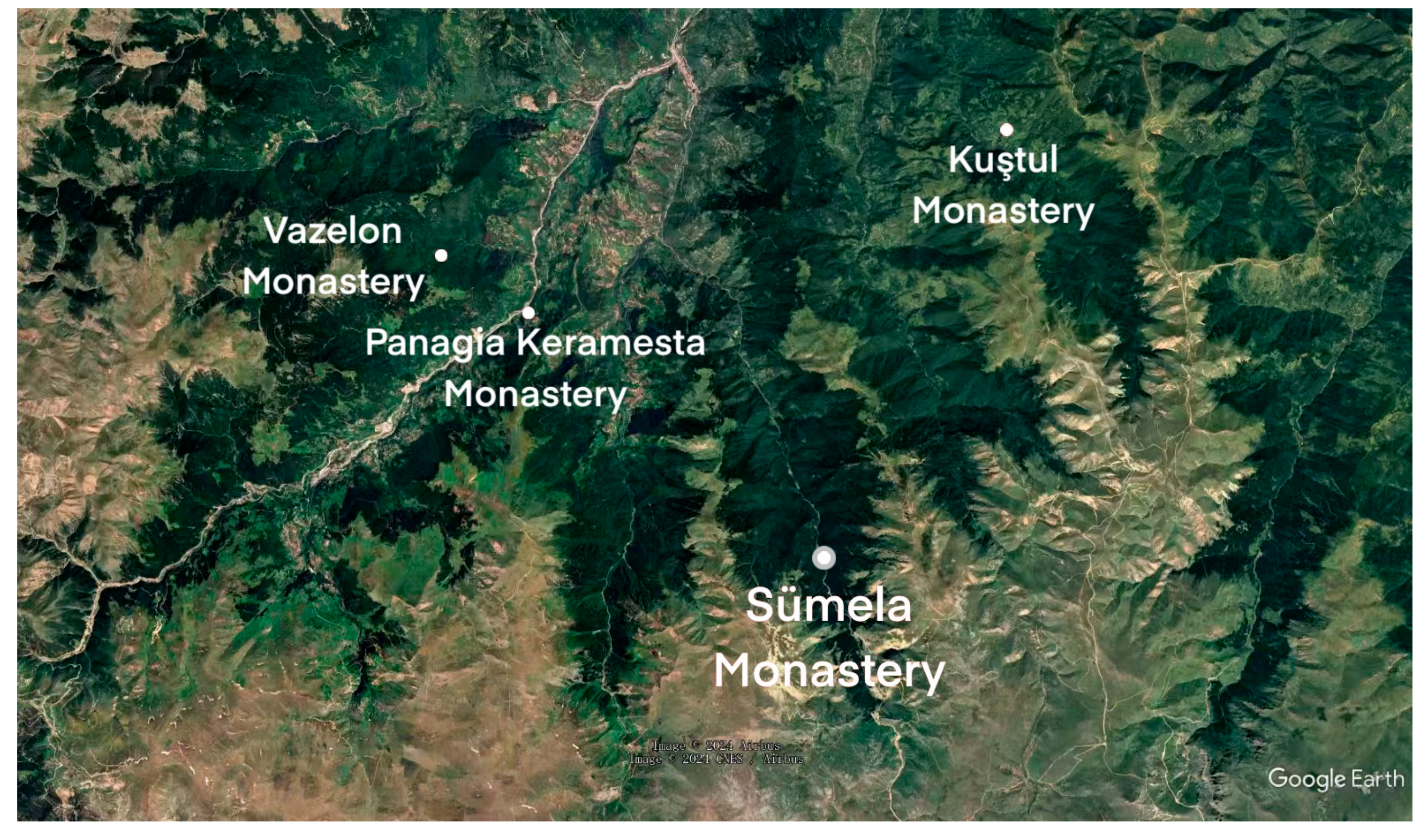
Figure 2.
(a) The slanted cross-lattice of wood strips on the mušebak (painted by Shangyi Zhou); (b) The projection of the roof of the centrally enclosed atrium (repainted by Yusheng Zou).
Figure 2.
(a) The slanted cross-lattice of wood strips on the mušebak (painted by Shangyi Zhou); (b) The projection of the roof of the centrally enclosed atrium (repainted by Yusheng Zou).
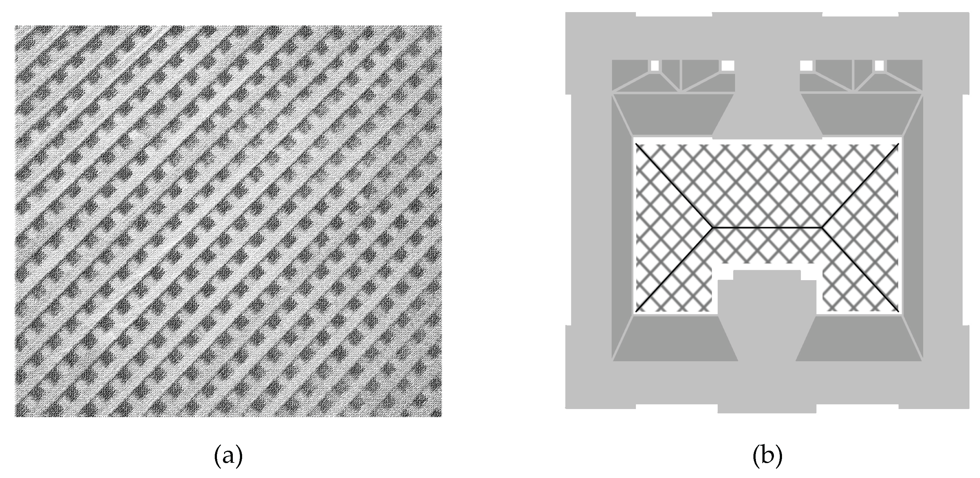
Figure 3.
The map of Huitong Village with its historical remains (made by Wei Yang and Yusheng Zou). Notes: 1 The Long Pond's boundary existing in the 1930s and disappearing in the 1980s; 2 The Long Pond’s boundary from the 1980s to the present; 3 The walls of the village that was built in the 1920s and disappeared in the 1960s; 4 The walls of the village from the 1920s to the 1980s; 5 The walls of the village from the 1920s to the present.
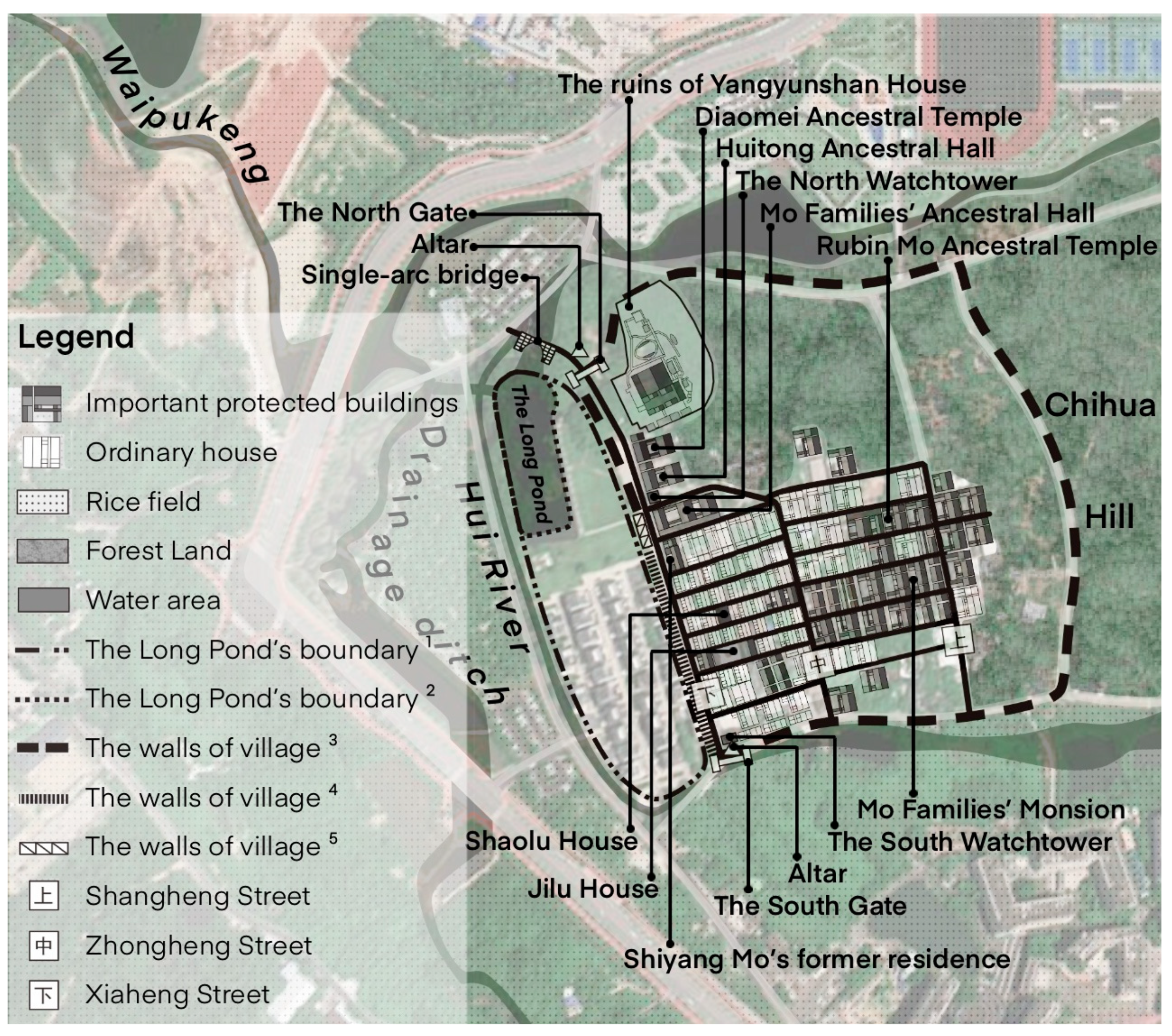
Figure 4.
The directions of the two visual corridors (made by Yusheng Zou and Shangyi Zhou).
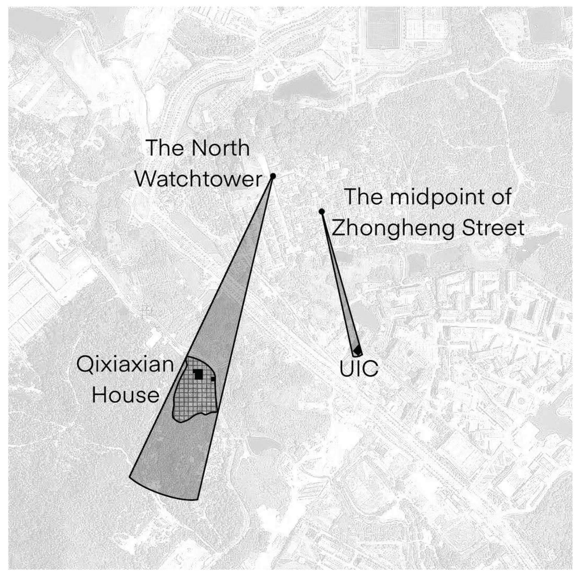
Figure 5.
The View of Qixiaxian Garden from the North Watchtower (Unable to reach the top of the watchtower, the research team used a drone to take a visual corridor shot above the North Watchtower on April 26, 2025).
Figure 5.
The View of Qixiaxian Garden from the North Watchtower (Unable to reach the top of the watchtower, the research team used a drone to take a visual corridor shot above the North Watchtower on April 26, 2025).
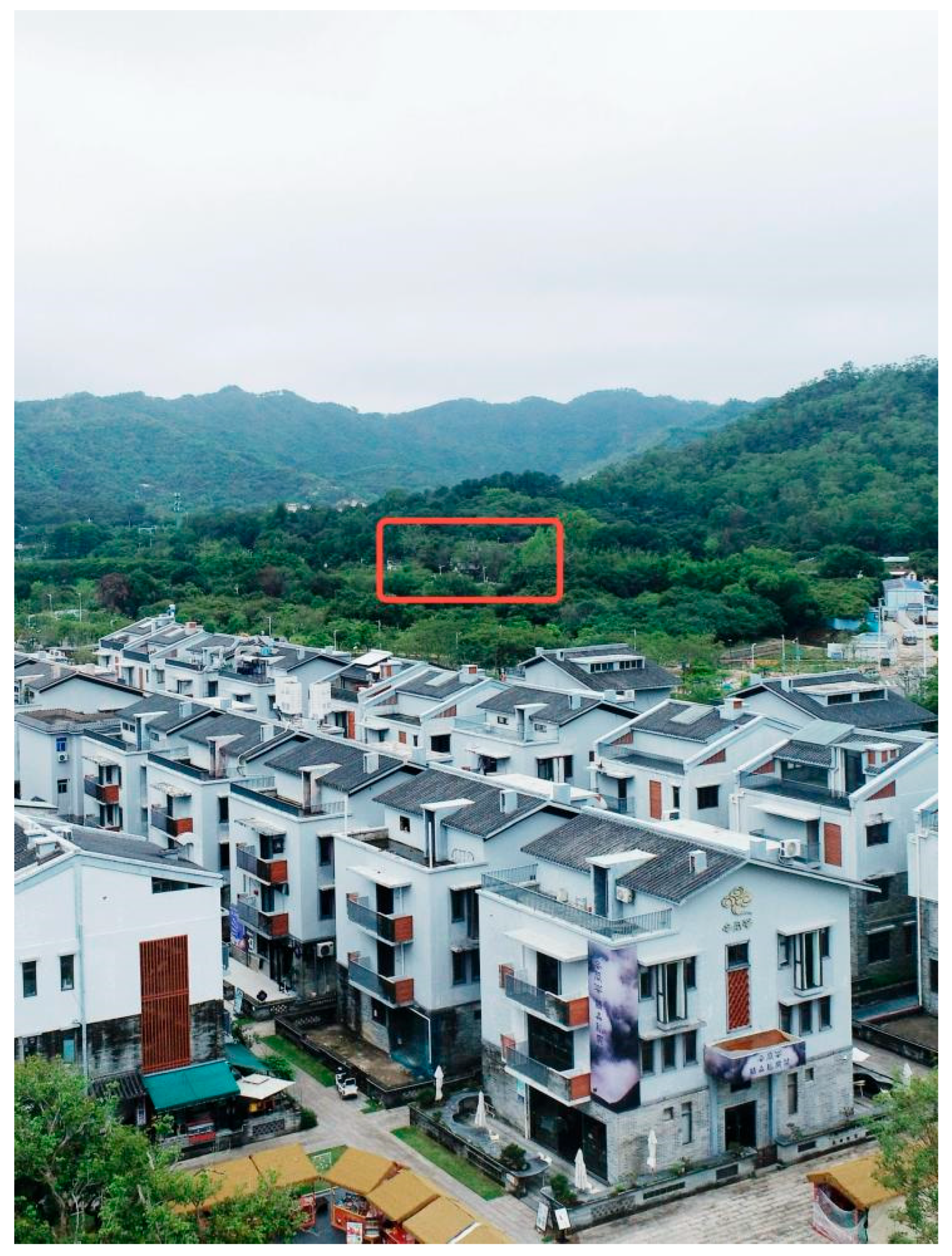
Figure 6.
The View of UIC building from Zhongheng Street (photo by Yusheng Zou on November 11, 2024).
Figure 6.
The View of UIC building from Zhongheng Street (photo by Yusheng Zou on November 11, 2024).
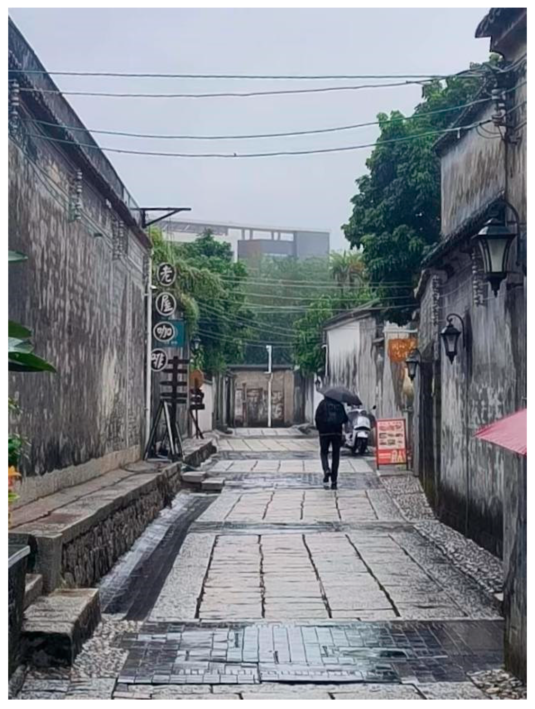
Figure 7.
The water system map of Huitong Village (made by Yusheng Zou).
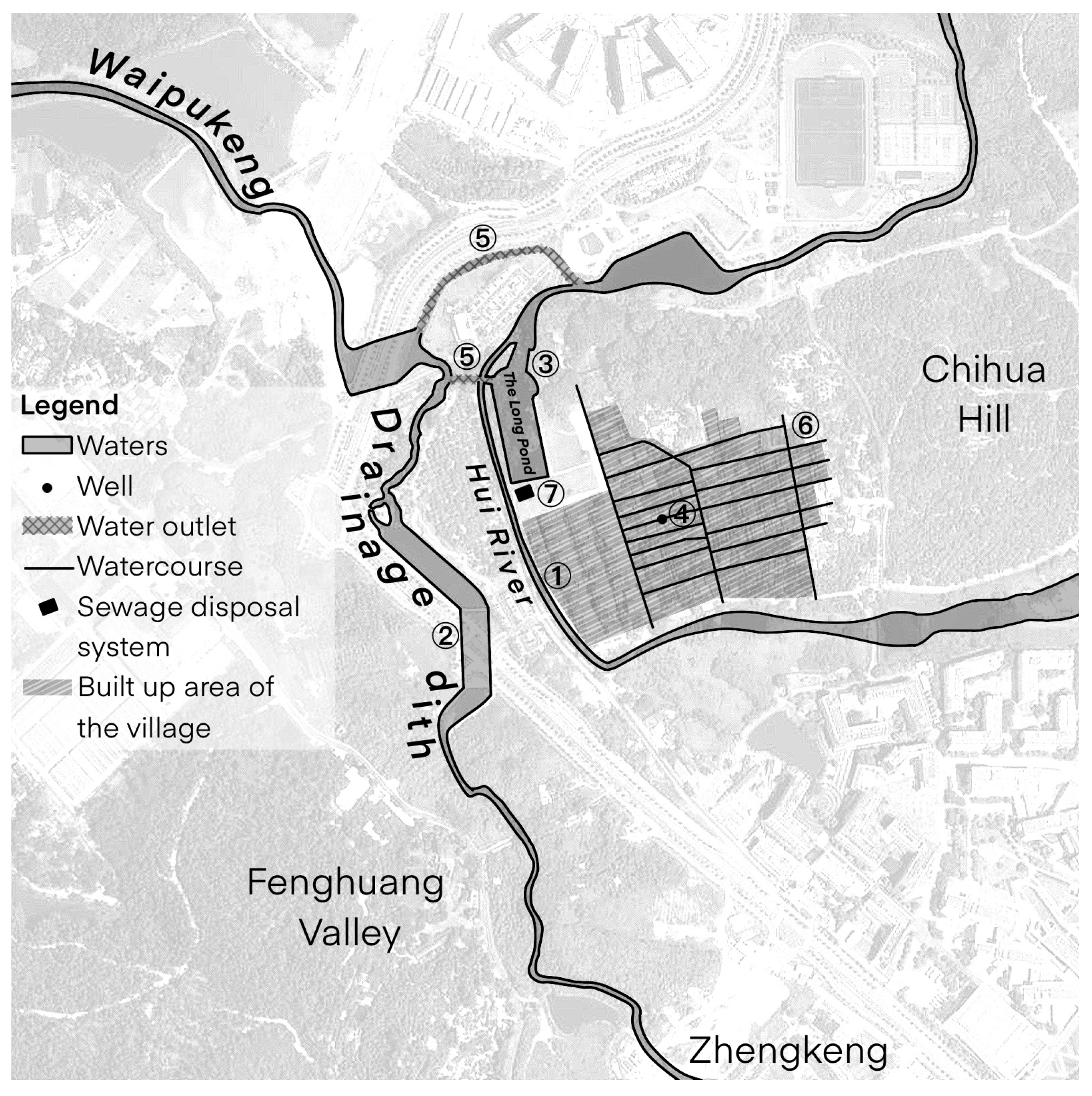
Figure 8.
Original boundary and proposed adjusted boundary of the buffer zone of Huitong Village (made by Yusheng Zou).
Figure 8.
Original boundary and proposed adjusted boundary of the buffer zone of Huitong Village (made by Yusheng Zou).
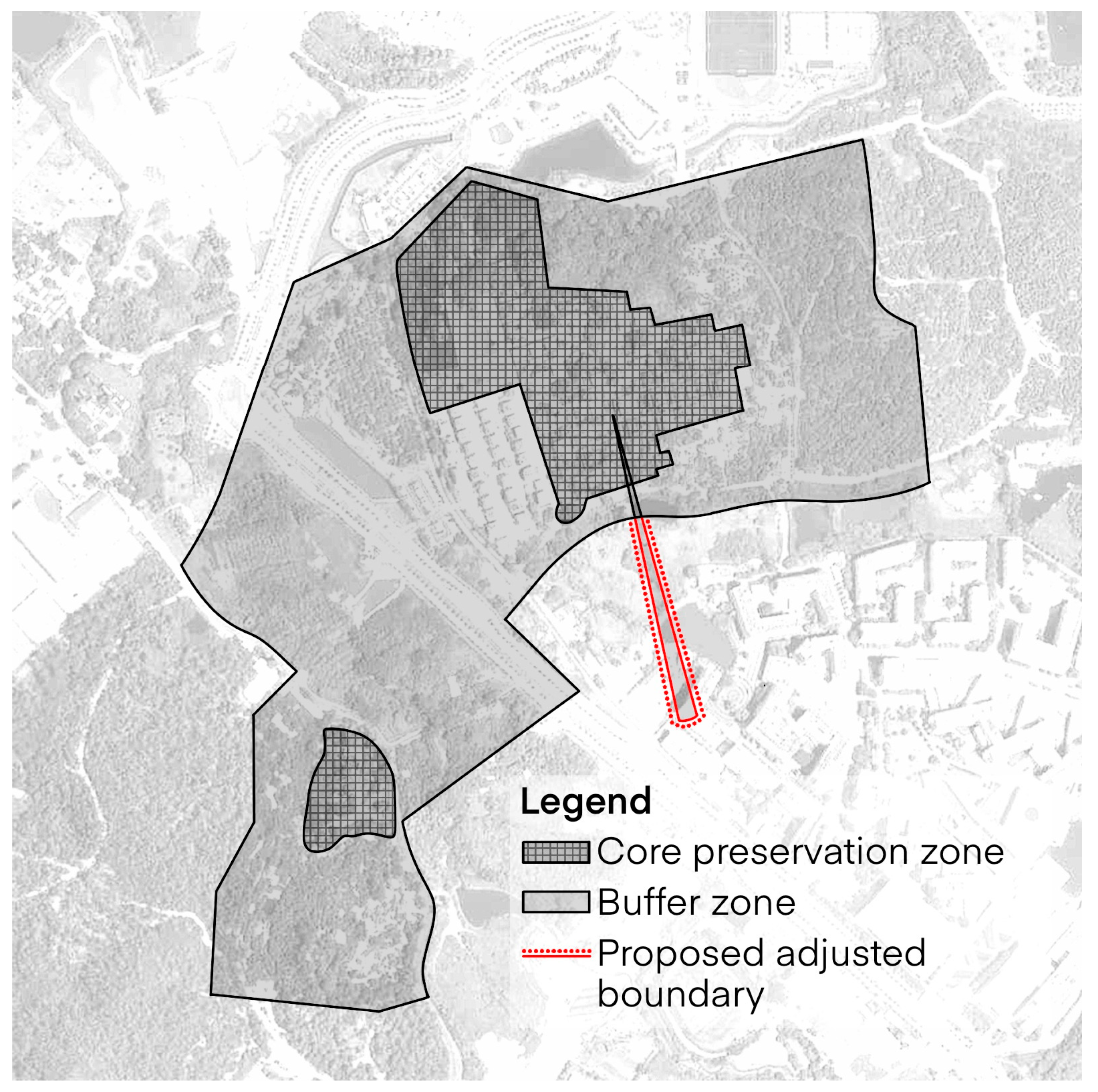
Figure 9.
The profile map of the height control for the visual corridor we proposed in this paper (Drew by Shangyi Zhou and Yusheng Zou). Notes: The baseline of the height limit is calculated from the baseline of the North Watchtower. The formula of height limit is formula (1):
Figure 9.
The profile map of the height control for the visual corridor we proposed in this paper (Drew by Shangyi Zhou and Yusheng Zou). Notes: The baseline of the height limit is calculated from the baseline of the North Watchtower. The formula of height limit is formula (1):
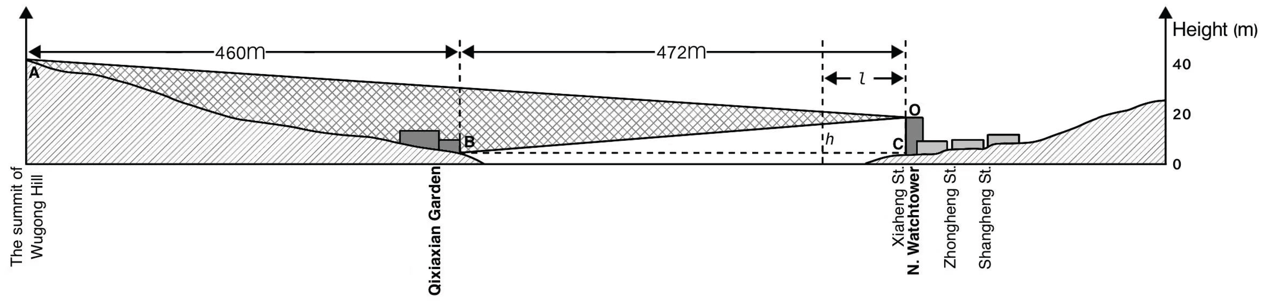

Table 1.
The survey of the current situation of cultural relics buildings and cultural relics sites.
Table 1.
The survey of the current situation of cultural relics buildings and cultural relics sites.
| name | Main damage phenomena |
|---|---|
| Single-arch bridge 1, 3 | It has been modified recently |
| The North Gate 1, 3 | Its wall is dry and alkaline, its door panel and latch are missing, and recently it has been fixed with a steel structure |
| Diaomei Ancestral Temple 1, 3 | It has been modified recently |
| Huitong Ancestral Hall 1, 3 | It has been renovated recently and the wall surrounding the North Watchtower is missing |
| The North Watchtower 1, 3 | It is basically in good condition, and its internal stairs are damaged |
| Mo Families' Ancestral Hall 1, 3 | It has been modified recently |
| Shaolu House 2, 3 | It is basically in good condition, and recently its walls were renovated |
| Jilu House 1, 3 | It has been modified recently |
| Huitong Academy 1, 3 | It is basically in good condition, and its walls were repainted |
| The South Watchtower 1, 3 | It is basically in good condition, and its walls have water stains |
| The South Gate 1, 3 | Its wall is dry and alkaline, its door panel and latch are missing, and recently it has been fixed with a steel structure |
| Rubin Mo Ancestral Temple 2, 3 | It is basically in good condition, with a wire connector on the wall |
| Mo Families' Mansion 1, 3 | It is basically in good condition |
| Qixiaxian Garden 1, 3 | It is basically in good condition, and its walls have water stains |
| Altar of God of Land and Grain 4 | It has been modified recently |
| The Ruins of Yangyunshan House 4 | Only its ruins remain, and its internal functions have become a parking place for sanitation facilities such as garbage trucks |
| Shiyang Mo's former residence 4 | Only its foundation remains, and it completely transforms into public space |
| Ancient village walls 4 | Only a small section of the ruins of it, three or four meters long and 20 centimeters high, is left, and the damage is so severe that it may collapse at any time, with traces of modern people fixing it. |
| Temple of Zhangwangye 4 | There are no sites or visual and written materials, only the words of it remain as oral history |
| Wenchang Pavilion 4 | There are video and written materials about it |
1 the first batch of cultural relics buildings announced by Zhuhai in 2012. 2 the second batch of historical buildings announced by Zhuhai in 2018. 3 cultural relic buildings. 4 history building ruins.
Table 2.
The key elements of water system in Huitong Village.
| element | order number | function |
|---|---|---|
| Hui River | ① | Natural runoff sources |
| Drainage ditch | ② | Flood discharge channel modified from natural river |
| The Long Pond | ③ | Collecting slope runoff from the mountains as a source of water for irrigation |
| well | ④ | The village’s living water sources in the past (now abandoned) |
| Water outlet | ⑤ | Connecting Hui River, drainage ditch and the Long Pond |
| Watercourse | ⑥ | The drainage channels in the village, mainly distributed along the streets and alleys |
| sewage disposal system | ⑦ | Treating domestic sewage in the village |
Disclaimer/Publisher’s Note: The statements, opinions and data contained in all publications are solely those of the individual author(s) and contributor(s) and not of MDPI and/or the editor(s). MDPI and/or the editor(s) disclaim responsibility for any injury to people or property resulting from any ideas, methods, instructions or products referred to in the content. |
© 2025 by the authors. Licensee MDPI, Basel, Switzerland. This article is an open access article distributed under the terms and conditions of the Creative Commons Attribution (CC BY) license (http://creativecommons.org/licenses/by/4.0/).
Copyright: This open access article is published under a Creative Commons CC BY 4.0 license, which permit the free download, distribution, and reuse, provided that the author and preprint are cited in any reuse.


