
Submitted:
13 February 2024
Posted:
14 February 2024
You are already at the latest version
Abstract
Flooding is one major environmental problem facing urban cities causing varying degree of damages to properties and disruptions to socio-economic activities. Nigeria is the most populated African country and Kano metropolis is the second largest urban center in Nigeria and the most populated in Northern Nigeria. The aim of the paper is to conduct flood risk assessment of Kano metropolis. The city is divided into two hydrological basins; Challawa and Jakara Basins. Flood frequency analysis for 2 to 100-year return periods were carried out for both the basins using Log-Pearson Type III distribution and flood inundation and hazard mappings were carried out. Social vulnerability to flood of both basins were carried out using MOVE framework. Assessment of flood risk were carried out using map algebra spatial analyst tool in ArcGIS 10.7. The result shows that an area of 50.91 and 40.56 km2 were vulnerable to a 100-year flood. The flood risk map for the two basins show that 10.50 km2 and 14.23 km2 of land in Challawa and Jakara basins respectively are affected by the risk of a 100-year flood out of which 11.48 km2 are built-up area. As the city is densely populated, with a population density of well over 20,000 persons per square kilometer in the highly built-up locations, this means that much more than 230,000 persons will be affected by the flood risk in the two basins
Keywords:
Flood hazard
; Social vulnerability
; Flood risk
; Flood mapping
; Kano metropolis
1. Introduction
In recent years, climate change and rapid urbanization of cities have caused significant urban flooding resulting in traffic disturbances, disruption of services, damage to properties and critical infrastructure, harm to vulnerable populations and sometimes loss of lives [1,2,3]. An important contribution to threats posed by floods is the generation of flood maps and the estimation of flood risk [4]. Generally, “risk” is defined as the potential consequences of a hazard and flood maps indicate the inundated areas based on the rising water levels, but flood maps alone are not adequate to assess risks to property, infrastructure and services due to flood events. Therefore, socio-economic factors are critical for flood risk assessment [5]. UNISDR [6] defined risk assessment as a process or application of a methodology for evaluating risk as defined by the geographic coverage of the hazard, the exposure of people, property and infrastructure to the hazard, and the vulnerability of people, property and infrastructure to the event. Flood risk assessment is a systematic procedure to identify, analyze and quantify the real and expected damage threats of flooding [7].
A flood hazard is a potentially damaging phenomenon which may cause loss of life or injury, property damage, social and economic disruption or environmental degradation [8]. Flood hazards have increased in recent years due to climate change, fast socio-economic development, population growth and inefficient use of land. Urban flood hazard assessment is important for the mitigation of floods and a necessary step for government policies on urban planning worldwide [4]. They help the planners manage better the sites for urban development and recognise areas that probably need stormwater runoff infrastructure [8]. Flood hazards have increased in recent years because of different factors, such as climate change, subsidence, fast socio-economic development, population growth, inefficient use of land and urbanization resulting in increased impervious surfaces [9,10]. Generally, flood hazard assessment and mapping are used to identify areas at risk of flooding, and consequently to improve flood risk management. The assessments and maps typically look at the expected extent and depth of flooding corresponding to various return periods [11]. In the context of Kano city, Temitope [12] generated unit hydrograph for River Jakara in Kano Metropolis using rainfall data. Abaje et al. [13] investigated the changing rainfall pattern in Kano over a period of 6 decades. Mohammed et al. [14] examined rainfall dynamics and climate change in Kano using 100 years of rainfall data and Mohammed et al. [15] examined gaps between climate change and urbanization in Kano city. No study known to the researcher considered flood hazard assessment for Kano city using flood frequency analysis. The lack of such a study on flood hazard estimation for the whole city makes it difficult to determine the possible areas that are prone to flood with a view to propose mitigation measures.
According to the Intergovernmental Panel on Climate Change [16], vulnerability is defined as “the degree to which a system is susceptible to, and unable to cope with, adverse effects of climate change, including climate variability and extremes”. Vulnerability determines how people will be affected and where they are spatially located [17]. Vulnerability is a multi-faceted concept with varying characteristics or dimension in nature. It is a set of multiple stressors that act together to determine the vulnerability of an area. These stressors include geographical location, exposure of population and infrastructure, socio- economic and cultural conditions, political and institutional structures as well as coping and adaptive capacity that differentiate the impacts on people and the human system [18]. This means also, that an area may be highly exposed to a hazard such as flood, but less vulnerable if it has adequate means to adapt to the flood. Vulnerability is therefore not a matter of only exposure, but rather a combination of exposure with local socio-economic factors [18]. Flanagan et al. [19] argued that social vulnerability refers to the socioeconomic and demographic factors that affect the resilience of communities. Social vulnerability can have multiple forms: it can be the state of the system before the event, the likelihood of outcomes in terms of economic losses and life lost, and it can also be the lack of capacities or weaknesses to face and recover quickly when the disaster strikes. A better understanding of the level of vulnerability and how the susceptible population is distributed can be beneficial for better management of flood risk [20]. There are numerous studies that have considered the vulnerabilities of social, economic and environmental systems to flooding [21,22,23,24,25]. Action aid [26] investigated vulnerability of six African cities on the basis of key management criteria including local people’s perceptions of the causes of flooding, adaptation and the community’s social coping capacity. Nabegu [24] assessed the vulnerability of households in the study area, to flood disaster, using questionnaires survey on infrastructure analysis and flood impact information. Social vulnerability refers to the characteristics of a person or group in terms of their capacity to anticipate, cope with, resist, and recover from the impact of a natural hazard [27]. Social vulnerability is related to gender, class, race, age, poverty and many more [28]. In this study, social vulnerability was considered because the study area is an urban center with significant population and valuable assets.
There are a number of multi-criteria evaluation concepts that are being used in assessing social vulnerability such as Analytical Hierarchy Process [29,30] and Method for the Improvement of Vulnerability in Europe (MOVE) framework [18]. In MOVE framework, characterization of vulnerability is done through three key factors, namely, 1) exposure, 2) susceptibility, and 3) lack of resilience [18]. MOVE framework was developed as a vulnerability assessment framework, arising from the MOVE project carried out from 2008–2011 in Europe. It was developed based on past vulnerability projects in Europe, but the concept is used worldwide [27]. Lianxiao and Morimoto [27] used MOVE framework and Information Entropy Method to carry out spatial analysis of social vulnerability to floods in Katsushika Ward, Tokyo, Japan. Williams and Muhammad [31] applied the MOVE framework with GIS to assess social vulnerability to malaria in Katsina-Ala, Benue State, Nigeria. Kablan et al. [18] used MOVE framework to assess social vulnerability to floods in Urban Côte d’Ivoire and Sane et al. [32] applied MOVE framework to assess social vulnerability to flood in Medina Gounass Dakar, Togo. The present study employed MOVE framework in assessing social vulnerability to floods Additionally, the study is the first to use flood frequency analysis to estimate floods hazards and then integrates flood hazard with flood vulnerability assessments to determine the flood risk in Kano metropolis.
2. Materials and Methods
2.1. The Study Area
Kano Metropolis is located in North-western Nigeria. The city’s nucleus is located on latitude 11.75oN and longitude 12.52oE. The metropolis covers total area of 499 km2 with a total population of about 3,931,300 inhabitants (as projected from the last 2006 Census figure). It is the second largest industrial center in Nigeria and the most populated city in Northern Nigeria. The population density of Kano is well over 20,000 per square kilometer in many locations [15]. The city experiences a mean annual rainfall of about 800 mm with wet season occurring mainly from June to September. Great temporal variation occurs in the amount of rainfall received and no two consecutive years record the same amount [33]. Figure 1 shows the administrative map of Kano metropolis. The city is drained by two river basins; Challawa and Jakara.
2.2. Determination of Flood Hazard
The hydrology of Kano city is divided into two main basins; Challawa and Jakara basins which serge as main receptacles of runoff from the city. Challawa was delineated into (15) subbasins with total drainage area of 105 km2 whereas, Jakara basin was delineated into (17) subbasins with a total drainage area of 110 km2 using Archydro tool and HEC-GeoHMS extentions in ArcGIS 10.7. Streamflow for the basins were generated using HEC-HMS rainfall-runoff transformation using maximum daily rainfall data collected for the area [34]. Goodness-of-fit test was carried on the flow data using Easyfit 5.0 and Log-Pearson Type III distribution was found to fit well. The flood frequency analysis and the corresponding flood inundation and hazard assessments were carried out for 2, 5, 10, 50 and 100-years floods using HEC-GeoRAS extension in ArcGIS 10.7 and hydraulic modelling in HEC-RAS 5.0. Flood hazard was classified using water depth and flood velocity as presented in Table 1 [35,36,37]. For example, a moderate sized person begins to lose stability in 0.9 m deep water flowing at 0.6 m/s. Deep inundation and high velocity of flood are classified as destructive while deep inundation with low velocity is classified as less destructive [38].
2.3. Determination of Social Vulnerability
Population figures from the immediate past census year (2006) was obtained from the National Population Commission and was projected using Equation (1).
 where P and Po = future and current population, r = growth rate, t = time in years.
The population density was obtained using Equation (2).
 where P = Number of people and A = land area
Social vulnerability to flood was carried out using MOVE framework [39]. Characterization of vulnerability was done through three key factors, namely, 1) exposure, 2) susceptibility, and 3) lack of resilience. These indicators are presented in Table 2.
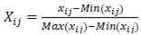
The normalized value of the indicators were computed using either Equations (3) or (4) [32]. When the indicators are related positively with the vulnerability, the normalized value of the indicator is computed using Equation (3):
When the indicators are related negatively with the vulnerability, the normalized value of the indicator is computed using Equation (4):
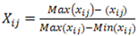 where, Xij is the normalized value of the indicator i of the component j; xij, is the value of the indicator i; max(xij) and min (xij) are respectively the maximum and minimum values of the indicators i of the component j.
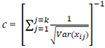
The weights to the individual indicator (wj) were assigned using a weighting method developed by [40] as reported in [18] and presented as Equation (5):
 where c is the normalized constant given by Equation (6)
The normalized indicators were aggregated using Equation (7)
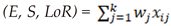 where w (0 < w < 1 and
  ) are the weights. Finally, the three components that is E, S, LoR were aggregated into final composite indicator of social vulnerability using Equation (8) [32].
 where V = vulnerability index, m = number of components, wj = weights for domain j and xj = index of component J (E, S, LoR). Therefore, the vulnerability weights were assigned for each category with 1 as the maximum in each case.
) are the weights. Finally, the three components that is E, S, LoR were aggregated into final composite indicator of social vulnerability using Equation (8) [32].
The results of social vulnerability index was saved in ArcGIS and was joined with flood inundation polygon for each scenario using the Join tool in ArcGIS 10.7. The Conversion tool was then used to produce raster maps of social vulnerability category. The vulnerability maps were reclassified with vulnerability weights estimated using Reclassify spatial analysts tool in ArcGIS 10.7 and finally, the reclassified vulnerability maps were then integrated to produce the final flood vulnerability map for each scenario. This was done using the Weighted sum tool in ArGIS 10.7. The maps were classified into five urban flood vulnerability classes as presented in Table 3:
3.2. Determination of Flood Risk
The flood risk map was produced as a product of hazard map and vulnerability map using Raster calculation in Map algebra spatial analyst tool in ArcGIS 10.7. The flood risk map for each scenario was produced and classified into four risk zones as High, Moderate, Low and No risk (Table 4).
3. Results
3.1. Flood Hazard
Table 5 and Table 6 show the Challawa and Jakara catchment areas flood hazard classification for different return periods. It is seen that, for Challawa basin, a 2-year flood cover a total area of 9.71 km2, while a 100-year flood covers a total area of 12.13 km2. Likewise, a 2-year flood covers a total area of 14.35 km2 while a 100-year flood covers a total area of 17.35 km2 for Jakara basin. Low hazard covered majority of the floodplain.
The maps of the flood hazard for 100-year return periods were produced for Challawa and Jakara basins as shown in Figure 2 and Figure 3 according to the classifications earlier described in Table 1. However, for all the return periods, the high hazard areas are located along the channel, but Jakara catchment is more prone to flood than Challawa due to higher land-use-land-cover.
3.2. Flood Vulnerability
The flood vulnerability maps of 100, 50, 25, 10, 5 and 2-year floods were obtained for Challawa basin, but only the 100-year return period is shown in Figure 4.
From the 100-year flood vulnerability map, the wards with high vulnerability to flood (HVF) are mainly in Kumbotso Local Government Area of Kano State. The wards that fall within the class of small vulnerability to flood (SVF) are in Municipal and Tarauni Local Government Area, while the remaining wards are classified as moderate vulnerability to flood (MVF) and there are no wards that are classified under very high vulnerability to flood (VHVF). Carefully examining the remaining flood scenarios that is, 50, 25, 10, 5, and 2-years flood vulnerability maps, it could be observed that, the majority of the areas fall within the class of MVF
Detail flood vulnerability classifications for Challawa basin corresponding to 100, 50, 25, 10, 5 and 2-year floods are presented in Table 7. It could be observed that, the vulnerability extent and severity increase with an increase in return periods. MVF covered an area which ranges between 19.37 to 41.23 km2 for 100 to 2-year return periods, whereas, HVF covered an area of 27.53 to 0 km2 for 100 to 2-year return periods. There was no area under VHVF for all the scenarios considered.
Figure 5 shows the 100-year flood vulnerability map for Jakara basin. It is observed that areas that fall in the region of HVF included some parts of Municipal and Fagge Local Government Areas while the areas classified under SVF included some parts of Gwale as well as Municipal and Fagge Local Government Areas. Observing the remaining flood scenarios that is 50, 25, 10, 5, and 2-years flood vulnerability maps, it could be observed that, the majority of the remaining areas fall within the class of MVF. Detail Jakara flood vulnerability classifications and the extent of each class for the 100, 50, 25, 10, 5 and 2-year return periods are presented in Table 8.
Table 8 shows the flood vulnerability information for Jakara basin. It could be seen that VSVF covered 0.23 km2 for all the return periods. MVF regions covered an area of 14.43, 17.31, 17.82, 30.16, 29.48, and 28.79 km2 for 100, 50, 25, 10, 5, and 2-year return periods respectively. While HVF regions covered an area of 22.86, 19.89, 17.15, 1.67, 0.89 and 0 km2 for 100, 50, 25, 10, 5, and 2-year return periods respectively. There was no VHVF region for all the return periods. The MOVE framework, used in this research, has provided information on the areas that need most intervention and facors that need to be given attention to effectively reduce existing susceptibility and increase resilience to flood exposure
3.3. Flood Risk
The area covered by each flood risk category for all the return periods is presented in Table 9 for Challawa basin. The table shows that the area affected by floods also increases as the return period increases. For a 2-year flow, low, medium and high-risk floods covered an area of 4.44, 2.57, and 0.55 km2 respectively while for 100-year flood, low, medium and high-risk areas covered 5.43, 3.85 and 1.22 km2 respectively. It is observed that, large percentage of the area affected by floods are mainly of low and moderate risks. The high flood risk zones are mostly areas lying along the channels.
The maps of flood risk were also obtained, but only that of 100-year flood is presented as Figure 6. It could be observed that Challawa basin has mainly two categories of risk zones (moderate and low risk zones) for all the return periods, but the high-risk zones in the catchment are very small.
Table 10 shows the elements, based on LULC classification, at risk of flooding. It could be observed that the LULC at risk of 2-year flood are 3.99, 2.66, 0.88 and 0.03 km2 of built-up area, bare-land, vegetation and water body respectively. Likewise, LULC at risk of 100-year flood are 4.98, 3.88, 1.54 and 0.10 km2 of built-up area, bare-land, vegetation and water body respectively.
Table 11 shows the area covered by each flood risk category for Jakara basin. A 2-year flood, with low-risk, medium-risk and high-risk were covered by 5.60, 3.73 and 1.04 km2 respectively, while a 100-year flood with low-risk, medium-risk and high-risk were covered by areas of 7.76, 5.17, and 1.30 km2 respectively. It is also observed that, large percentage of the area affected by the floods are mainly of low and moderate risks. The high flood risk zones are mostly infrastructures built along the channels
The maps of Jakara flood risks were obtained, but only that of 100-year flood is presented as Figure 7. It could be seen that Jakara basin has similar flood risk zone with Challawa basin. Table 12 also shows the elements, based on LULC classification, at risk of flooding for Jakara basin. It could be observed that the LULC at risk of 2-year flood are 4.17, 3.75, 1.87 and 0.09 km2 of built-up area, bare-land, vegetation and water body respectively. Likewise, LULC at risk of 100-year flood are 6.50, 4.85, 2.70 and 0.17 km2 of built-up area, bare-land, vegetation and water body respectively. The built-up area make-up the highest land cover class at risk of flooding followed by bare land. This is due to the urban nature of the basin with considerable infrastructures in place such as residential buildings, roads, schools, hospitals, etc. This agrees with findings of [42] Mukhtar (2018) who also attributed the flood in Kano to increased LULC. As the city’s population density is well over 20,000 persons per square kilometer in the highly built-up locations, this means that much more than 100,000 and 130,000 persons will be affected by flood risk in the Challawa and Jakara basins respectively.
4. Discussion
Flood has been a major source of concern arising from the huge economic losses encountered. The type of flood in Kano is pluvial and usually occurs annually during rainy seasons and affect mainly the urban areas in Nigeria. Such floods which are arguably unprecedented in recent times are caused by more frequent and severe rainfall which overwhelms the capacity of drainage systems. Nkwunonwo [23] reported that flooding occurs annually during rainy seasons, between July and October, ravaging many cities in Nigeria. Presently, the occurrence of such floods due to poor urban planning is an important issue in flood risk mitigation. The pluvial flooding occurs when rainfall-runoff, which ought to be evacuated by the drainage system, remains on impermeable surfaces and flows overland or into local depressions and topographically low areas to create temporary ponds. It mostly occurs after a short, intense downpours which cannot be evacuated quickly enough by the drainage system or seeped into the ground [44]. Built environments generate higher surface runoff, in excess of local drainage capacity, thereby causing local floods [10,45]. Intense urbanization, rapid conversion of green spaces to residential and commercial areas and neglect to town-planning and landscape conservation has resulted into the emergence of urban slums in the city which has further aggravated flood risk [46].
Climate change impacts on urban drainage systems is also known to have severe impact on urban drainage. The climate change increases the intensity of rainfall events posing a major threat to stormwater infrastructure systems [47]. Higher rainfall intensities lead to more severe storms, with expected increases in damages to urban centers. Pluvial flooding has been predicted to become more frequent due to climate change and urbanization [48]. The Kano city is extremely overcrowded which constantly threatens the city’s infrastructural management systems. Due to the population size, the sewage and waste water management system is overburdened, the drainage network system is inadequate, and there are cases of dumping of household and commercial refuse in open landfills and direct discharges to the streams and drains. Integration of urban growth and climate change scenarios into flood risk management models as proposed by researchers [49,50] could go a long way in addressing flood issues in developing countries. In the absence of climate change prediction models, flood hazard mapping using flood frequency estimates coupled flood vulnerability can serve as viable tools to address flood problems in developing countries.
5. Conclusions
Flood frequency analysis for 2, 5, 10, 25, 50 and 100-year return periods were carried out using Log Pearson Type III distribution and flood hazard and inundation mappings for Challawa and Jakara basins of Kano metropolis were developed. For the 100-year return period floods, a total area of 12.13 km2 would be inundated for Challawa basin while a total area of 17.36 km2 would be inundated for Jakara basin. Generally, for both catchment areas it can be concluded that, most of the flood hazard areas fall within the category of low and medium hazards, but high hazard areas are also located along the channels and districts that are prone to flooding were identified. Social vulnerability was carried out and the districts that fall within the categories of VSVF, SVF, HVF, MVF and SVF were identified and classified for return periods of 2 to 100-year floods. A total area of 50.91 and 40.56 km2 were found to be affected by the different categories of vulnerabilities for the 100-year flood, but was no VHVF zone for all the return periods considered. The flood risk map for the two basins were developed, and 10.50 km2 of land was affected by the risk of a 100-year flood out of which 4.98 km2 is built-up area in Challawa basin. For Jakara basin, 14.23 km2 of land area was affected out of which 6.50 km2 is a built-up area. As the city is densely populated, with a population density of well over 20,000 persons per square kilometer in the highly built-up locations, this means that much more than 230,000 persons will be affected by flood risk in the two basins.
Author Contributions
“Conceptualization, S.D. and A.M; methodology, A.M and A.A; investigation, A.M and S.D.; resources, A.A.; data curation, S.I.A; writing—A.M and S.I.A; writing—A.A; visualization, S.I.A; supervision, S.D; project administration, A.A.” All authors have read and agreed to the published version of the manuscript.
Data Availability Statement
The data presented in this study are available on request from the corresponding author. However, the data is not publicly available due to constraints.
Acknowledgments
This study is supported via funding from Prince Sattam bin Abdulaziz University project number (PSAU/2024/R/1445).
Conflicts of Interest
Authors declare no conflict of interest.
References
- Rangari, VA, Umamahesh, NV, Patel AK. Flood-hazard risk classification and mapping for urban catchment under different climate change scenarios: A case study of Hyderabad city. Urban Climate 2021, 36, 100793. [CrossRef]
- Yiyi H, Stephan T, Paolo A, Jun R. 2021. Flood impacts on urban transit and accessibility—A case study of Kinshasa. Transportation Research Part D: Transport and Environment, 2021, 96, 102889, ISSN 1361-9209. [CrossRef]
- Adegun, OB. Flood-related challenges and impacts within coastal informal settlements: a case from Lagos, Nigeria. International J. of Urban Sustainable Development 2023, 15, 1–13. [Google Scholar] [CrossRef]
- Cai S, Fan J, Yang W. Flooding risk assessment and analysis based on GIS and the TEN-AHP method: A Case Study of Chongqing Chaina. Atmosphere 2021, 12, 623. [Google Scholar] [CrossRef]
- Armenakis, C.; Du, E.X.; Natesan, S.; Persad, R.A.; Zhang, Y. Flood Risk Assessment in Urban Areas Based on Spatial Analytics and Social Factors. Geosciences 2017, 7, 123. [Google Scholar] [CrossRef]
- UNISDR (United Nations International Strategy for Disaster Reduction). UNISDR terminology on disaster risk reduction. Geneva: UNISDR, 30, 2015.
- Zhang X, Yi L, Zhao D. Community-based disaster management: A review of progress in China. Natural Hazards, 2013, 65(3), 2215-2239.
- Bathrellos GD, Karymbalis E, Skilodimou1, HD, Gaki-Papanastassioul K, Baltas EA. Urban flood hazard assessment in the Basin of Athens Metropolitan City, Greece. Environ Earth Science 2016, 75, 319. [Google Scholar] [CrossRef]
- Bruijn K.M, Klijn F, Van de Pas B, Slager CTJ. Flood fatality hazard and flood damage hazard: combining multiple hazard characteristics into meaningful maps for spatial planning. Natural Hazards and Earth System Science 2015, 15, 1297–1309. [CrossRef]
- Aldrees A, Dan’azumi S. Application of Analytical Probabilistic Models in Urban Runoff Control Systems’ Planning and Design: A Review. Water 2023, 15, 1640. [Google Scholar] [CrossRef]
- UN Environment–DHI Center, CTCN, UNEP. Flood hazard assessment and mapping; A practitioner’s guide to adaptation technologies for increased water sector resilience climate change adaptation technologies for water. 2021, Accessed from http//www.unepdhi.org/publications on 9th November, 2021.
- Temitope, EO. Generation of Unit Hydrograph for River Jakara in Kano Metropolis. M.Eng. Thesis, Department of Civil Engineering, Bayero University Kano, 2010. [Google Scholar]
- Abaje I B, Ndabula C, & Garba AH. Is the Changing Rainfall patterns of Kano State and its Adverse Impacts an Indication of Climate Change? European Scientific Journal 2014, 10(2), 7857–7881. [Google Scholar]
- Mohammed MU, Abdulhamid A, Badamasi MM, Ahmed M. Rainfall Dynamics and Climate Change in Kano, Nigeria. J. of Scientific Research and Report, 2015, 7(5), 386-395.
- Mohammed MU, Hassan NI, Badamasi MM. In search of missing links: Urbanization and climate change in Kano Metropolis, Nigeria. Intern. J. of Urban Sustainable Development. 2019, 11(3), 309 - 318. [CrossRef]
- IPCC (Intergovernmental Panel on Climate Change). Climate change impacts, Adaptation and vulnerability, contribu tion of Working Group II to the Fourth Assessment Report. Report, Summary for Policy Makers. 2014.
- Okayo J, Odera P, Omuterema S. Socio-economic characteristics of the community that determine ability to uptake precautionary measures to mitigate flood disaster in Kano Plains, Kisumu County, Kenya. Geoenvironmental Disasters, 2015, 2(26). [CrossRef]
- Kablan MKA, Dango K, Coulibaly M. Assessment of social vulnerability to flood in Urban Cote d’Ivoire using the MOVE frame work. Water, 2017, 9(292),1-18.
- Flanagan BE, Gregory EW, Hallisey EJ, Heitgerd JL, Lewis B. A Social Vulnerability Index for Disaster Management. J. of Homeland Security and Emergency Management, 2011, 8(1). [CrossRef]
- Rahman MA. 2018. Social vulnerability to flood: An integrated spatial assessment in the United States. Association of American Geographers, Washington, DC, USA, 2018.
- Ajibade I, McBean G, Bezner-kerr R. Urban flooding in Lagos, Nigeria: Patterns of vulnerability and resilience among Women. Global Environmental Change, 2014, 23, 1714-1725.
- Akukwe, T. I., & Ogbodo, C. Spatial Analysis of Vulnerability to Flooding in Port Harcourt Metropolis, Nigeria. SAGE Open, 2015, 5(1). [CrossRef]
- Nkwunonwo UC, Whitwork M, Baily B. Relevance of social vulnerability assessment to flood risk reduction in the Lagos Metropolis of Nigeria. J. of Applied Science & Technology, 2016, 8, 366-382.
- Nabegu, AB. Analysis of vulnerability to flood disaster in Kano State. Greener Journal of Physical Sciences 2014, 4, 22–29. [Google Scholar]
- Olajuyigbe AE, Rotowa OO, Durajaye E. An assessment of flood hazard in nigeria; the case of Mile 12, Lagos. Mediterranea Journal of Social Sciences, 2012, 3, 367-375.
- Action Aid. Climate change, urban flooding and the rights of urban poor in Africa. Key findings from six African cities. London; Action Aid International, 2006.
- Lianxiao M, Morimoto T. Spatial analysis of social vulnerability to floods based on the MOVE framework and Information Entropy Method: Case Study of Katsushika Ward, Tokyo, Japan. J. of Sustainability 2019, 11, 1–19. [Google Scholar]
- Younus M, Kabir M. Climate change vulnerability assessment and adaptation of Bangladesh: Mechanisms, Notions and Solutions. Sustainability 2018, 10, 4286. [Google Scholar] [CrossRef]
- Musungu K, Motala S, Smit J. Using Multi-criteria evaluation and GIS for flood risk analysis in informal settlements of Cape Town: The case of Graveyard Pond. South African Journal of Geomatics, 2012, 1(1), 1-15.
- Shuaibu, A.; Hounkpè, J.; Bossa, Y.A.; Kalin, R.M. Flood Risk Assessment and Mapping in the Hadejia River Basin, Nigeria, Using Hydro-Geomorphic Approach and Multi-Criterion Decision-Making Method. Water 2022, 14, 3709. [Google Scholar] [CrossRef]
- Williams HT, Muhammed BU. Modelling social vulnerability to malaria risk in Katsina-Ala Local Government Area, floods, Benue State Nigeria. J. of Geography & Environmental Earth Science 2018, 14, 2454–57352.
- Sane OD, Gaye AT, Diakhate M, Aziadekey M. Social vulnerability assessment to flood in Medina Gounass Dakar. J. of Geographic Information System 2015, 7, 415–429. [Google Scholar] [CrossRef]
- Mustapha A, Yakudima II, Alhaji M, Nabegu AB, Dakata GAF, Umar AY, Musa UB. Overview of the physical and human setting of Kano Region, Nigeria. J. of Geography 2014, 1, 1–12.
- Mohammed A, Dan’azumi S, Modibbo AA, Adamu AA, Ibrahim Y. Rainfall-runoff modeling for Challawa and Jakara Catchment Areas of Kano City, Nigeria. Arid Zone Journal of Engineering, Technology and Environment 2021, 17, 439–452. [Google Scholar]
- 35. Daffi RE, Otun JA. Ismail A. Flood hazard assessment of River Dep Floodplains in North-Central Nigeria. Intern. J. of Water Res and Env. Engineering 2014, 6, 67–72. [CrossRef]
- Daffi RE, Ismail A, Egharevba NS. Use of geographic information system techniques for flood inundation mapping of low-lying areas of River Dep Basin. Nigerian J. of Tropical Engineering 2015, 8, 1–8.
- Cançado V, Brasil L, Nascimento N, Guerra A. Flood risk assessment in an urban area: Measuring hazard and vulnerability. 11th International Conference on Urban Drainage, 2008, Edinburgh, Scotland, UK.
- Olasunkanmi AB, Dan’azumi S. Flood inundation and hazard mapping of River Zungur Watershed using GIS and HEC-RAS Models. Nigerian Journal of Technology 2018, 37, 1162–1167. [CrossRef]
- Birkmann, J. Framing vulnerability, risk and societal responses, the MOVE framework. Natural Hazards 2013, 67, 193–211. [Google Scholar] [CrossRef]
- Iyengar, N.S. and Sudarshan, P. A Method of Classifying Regions from Multivariate Data. Economic and Political Weekly 1982, 17, 2047–2052. [Google Scholar]
- Karmaoui, A., Balica, S. F., and Messouli, M.: Analysis of applicability of flood vulnerability index in Pre-Saharan region, a pilot study to assess flood in Southern Morocco. Nat. Hazards Earth Syst. Sci. Discuss. 2016, 96. [CrossRef]
- Sharma SV, Roy PS, Chakravarthi V, Rao SG. Flood risk assessment using multi-criteria analysis: a case study from Kopili River Basin, Assam, India. J. of Geomatics Natural Hazards and Risk 2018, 9, 79–93. [CrossRef]
- Mukhtar I. Analysis of flood risk and vulnerability in kano metropolis, Kano State, Nigeria. PhD Thesis. Department of Geography. Ahmadu Bello University Zaria. Nigeria, 2018.
- Houston D, Werritty A, Bassett D, Geddes A, Hoolachan A, McMillan M. Pluvial (Rain-related) Flooding in Urban Areas: The Invisible Hazard, 2011, Joseph Rowntree Foundation.
- Lisetskii F.N, Buryak ZA. Runoff of Water and Its Quality under the Combined Impact of Agricultural Activities and Urban Development in a Small River Basin. Water 2023, 15, 2443. [CrossRef]
- Nasidi NA. Urbanism and the Conservation of The Natural Environment for Sustainable Development: A Case Study of Kano State, Nigeria, 1989-2020. [Research Report] IFRA-Nigeria Working Papers Series 87, IFRA-Nigeria. 2022, pp.1-20. ⟨hal-03762087⟩.
- Cook LM, McGinnis S, Samaras C. The effect of modeling choices on updating intensity-duration-frequency curves and stormwater infrastructure designs for climate change. Climatic Change 2020, 159, 289–308. [Google Scholar] [CrossRef]
- WMO (World Meteorological Organization), GWP (Global Water Partnership). Integrated Flood Management Tools Series No.20, 2013.
- Khan DM, Veerbeek W, Chen AS, Hammond MJ, Islam F, Pervin I, Djoidjevic S, Buttler D. Back to the Future: Assessing Damage of 2004 Dhaka Flood in the 2050 Urban Environment. J. of Flood Risk Management 2016. [CrossRef]
- Rosmadi, H.S.; Ahmed, M.F.; Mokhtar, M.B.; Lim, C.K. Reviewing Challenges of Flood Risk Management in Malaysia. Water 2023, 15, 2390. [Google Scholar] [CrossRef]
Figure 1.
Map of Kano metropolis.
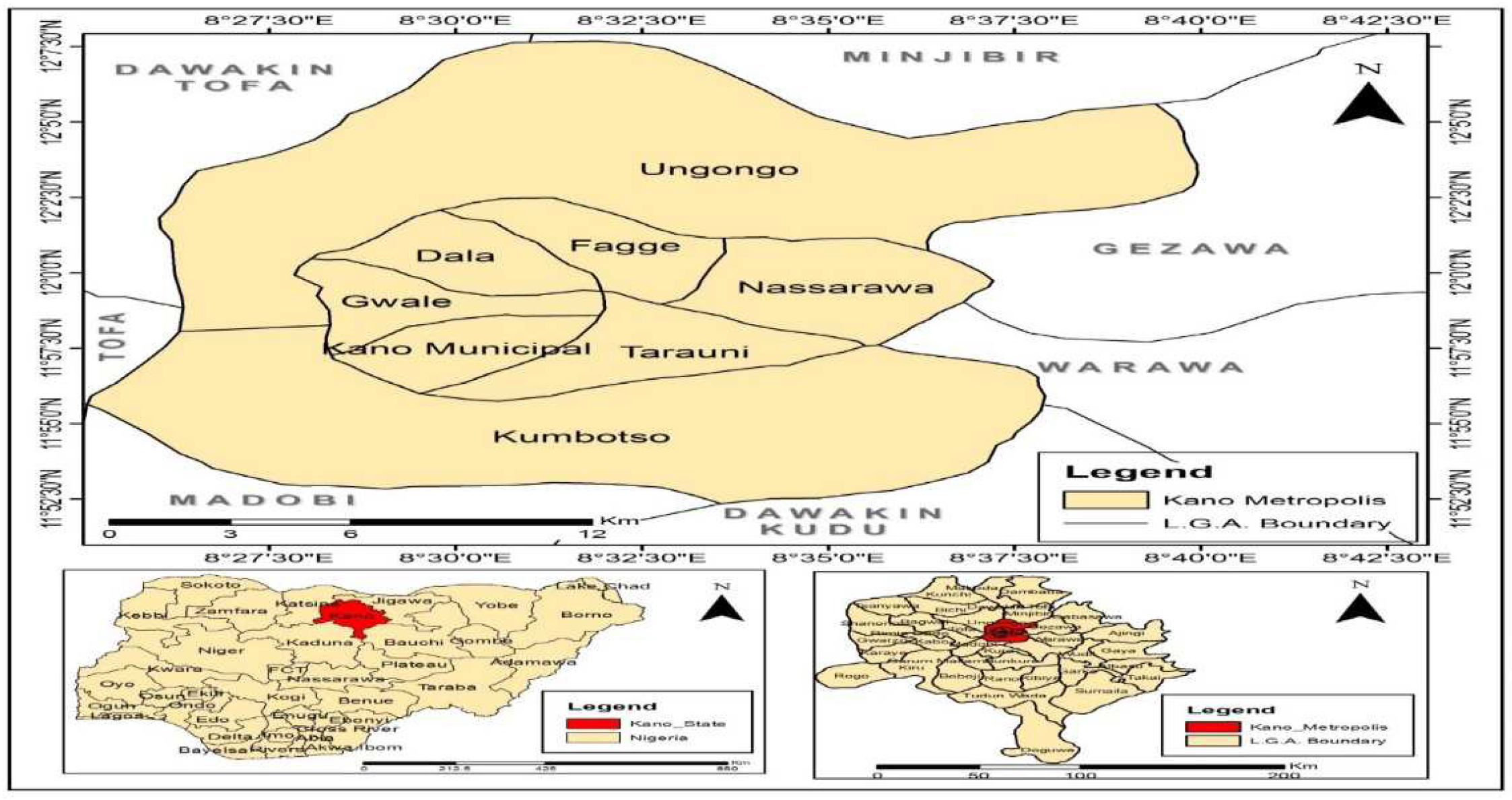
Figure 2.
100-year flood hazard map for Challawa basin.
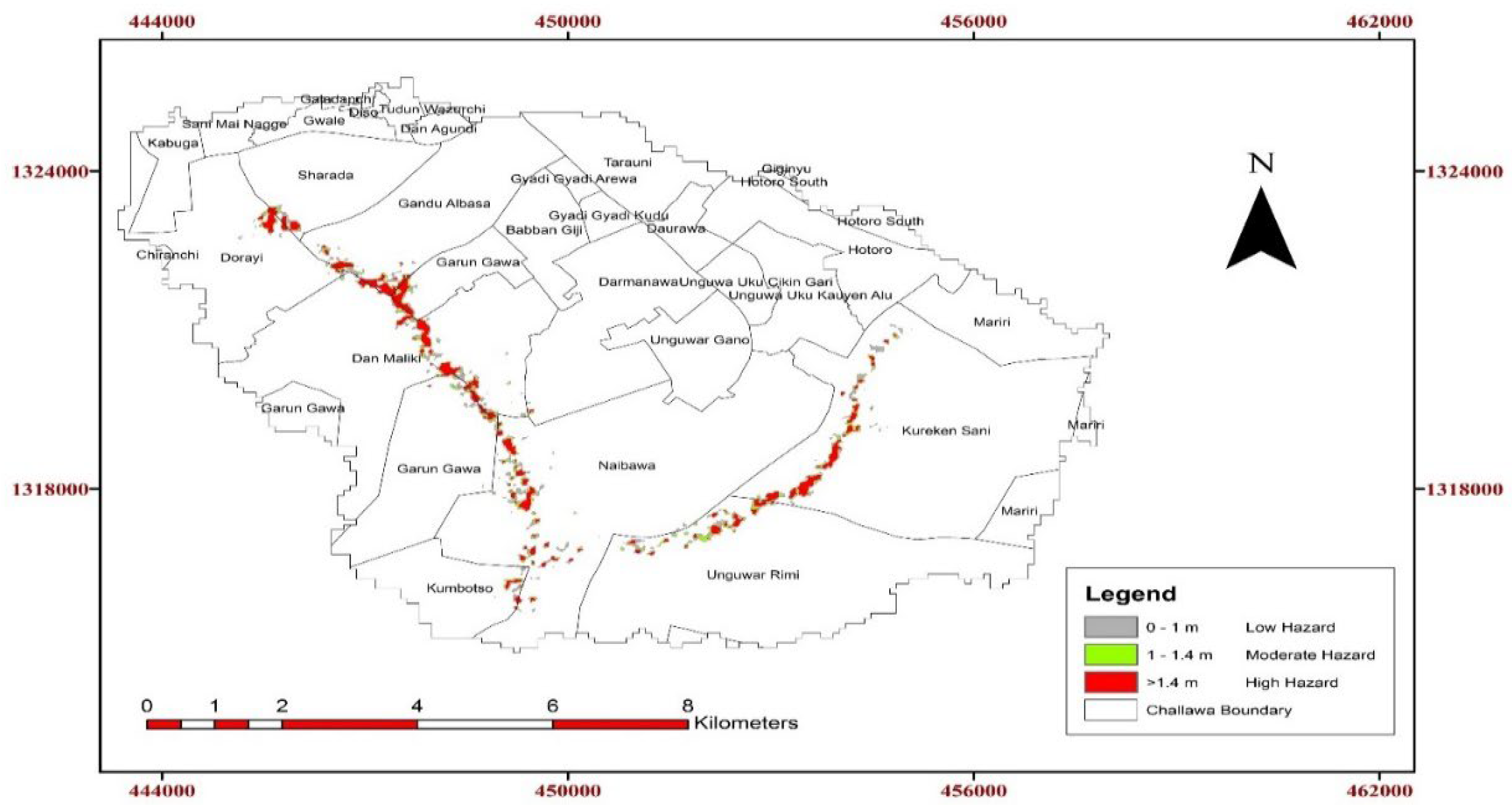
Figure 3.
100-year flood hazard map for Jakara basin.
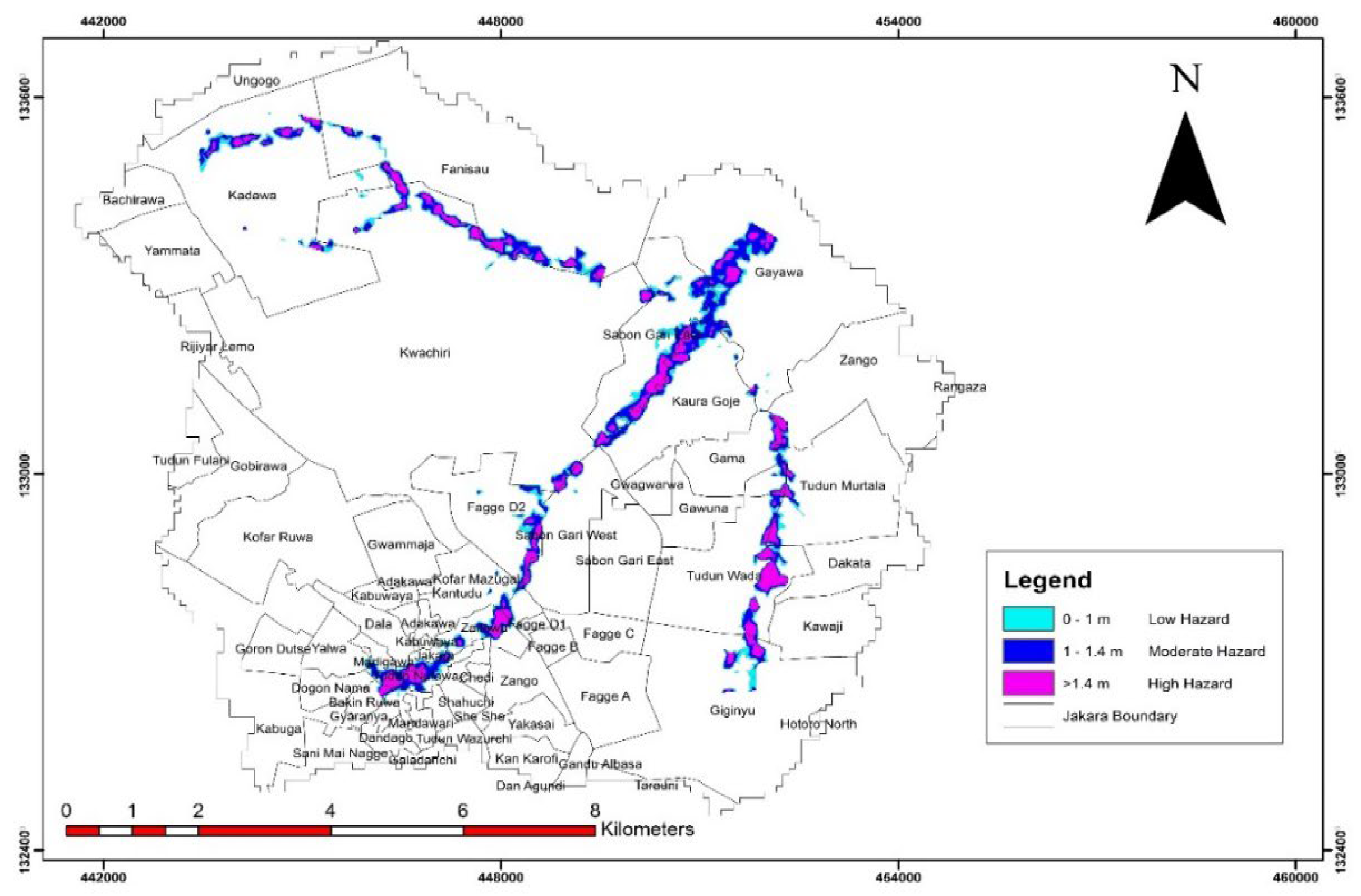
Figure 4.
100-year flood vulnerability map for Challawa basin.
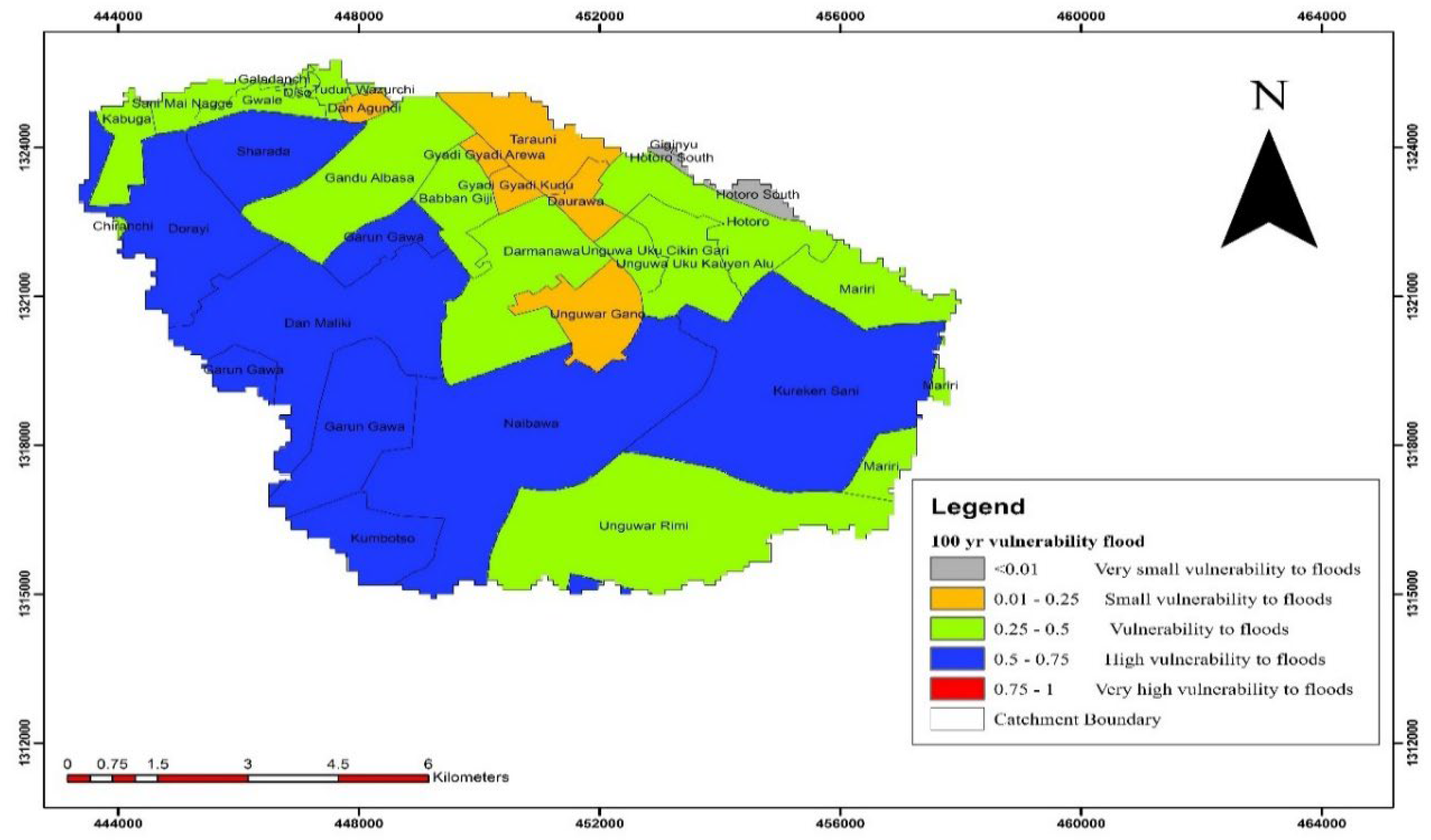
Figure 5.
100-year flood vulnerability map for Jakara basin.
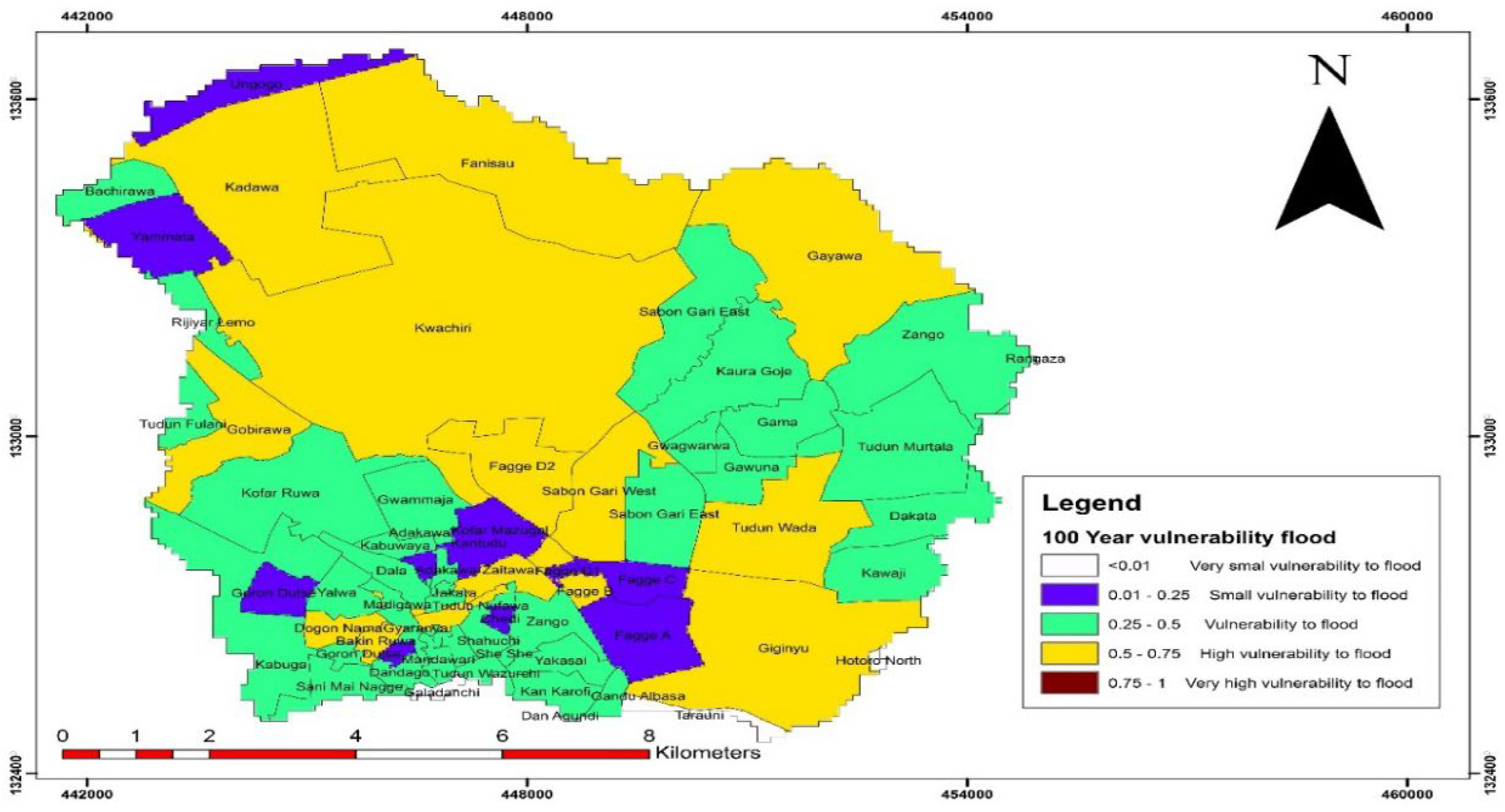
Figure 6.
100-year flood risk map for Challawa basin.
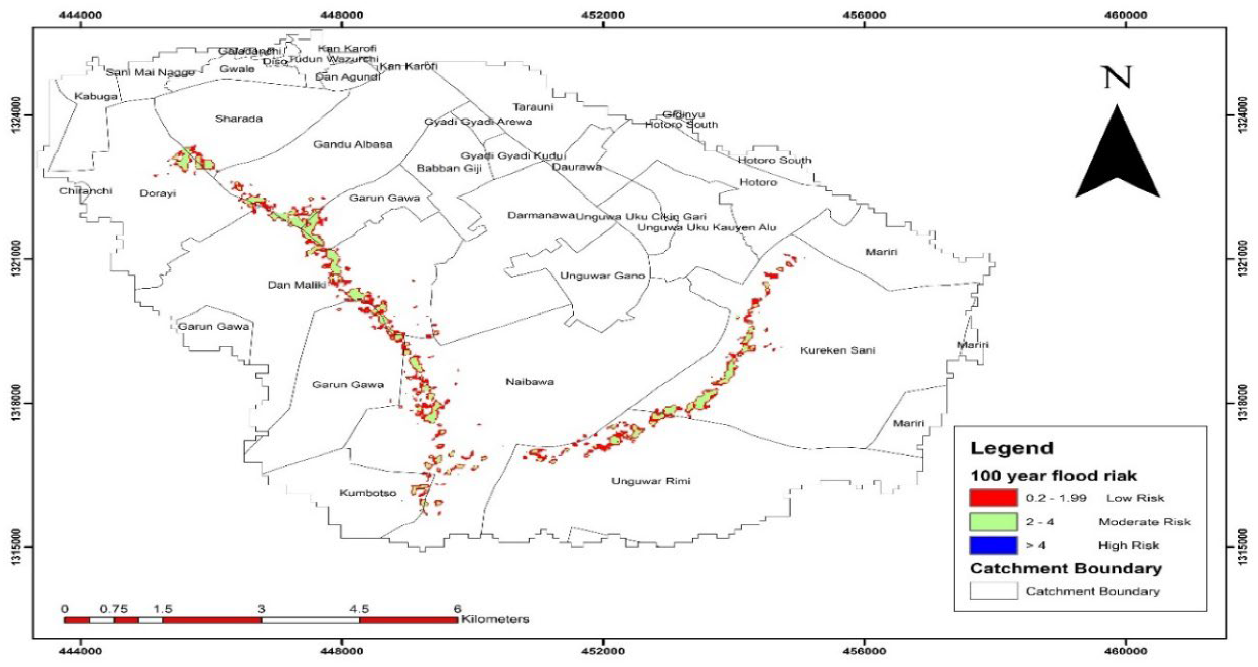
Figure 7.
Jakara flood risk map for 100-year return period.
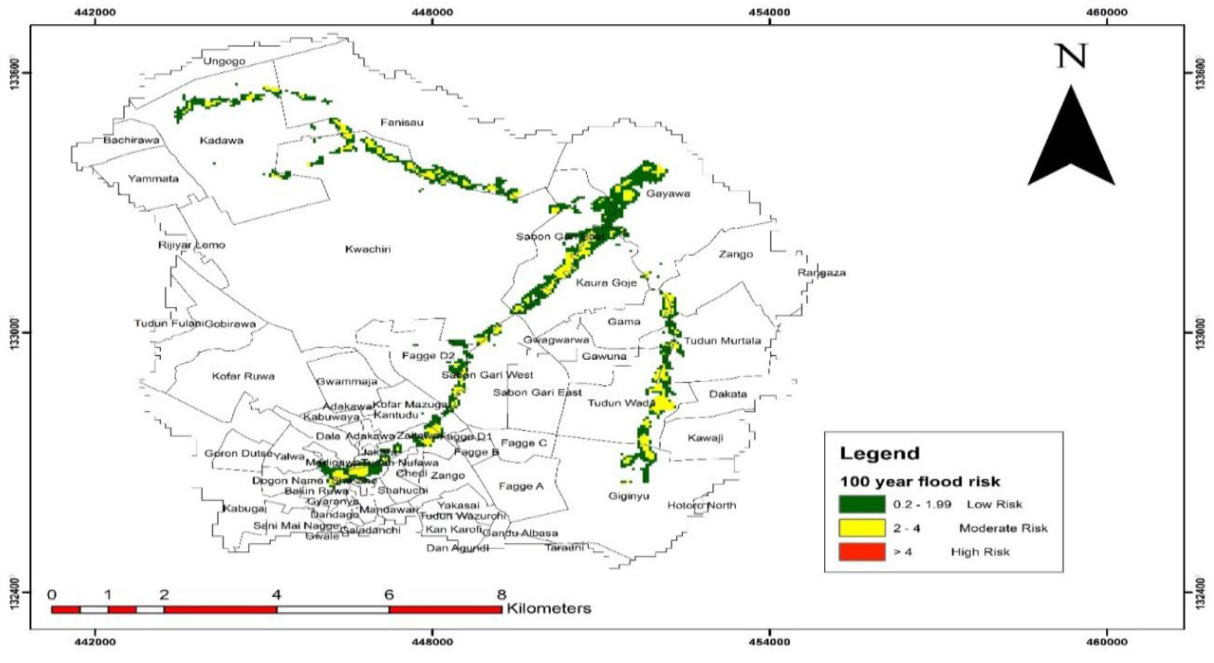

Table 1.
Hazard as a function of flood water depth and velocity [35].
Table 1.
Hazard as a function of flood water depth and velocity [35].
| Hazard Classification | Flood Depth (m) | Flood Velocity (m/s) |
|---|---|---|
| High | > 1.4 | > 2 |
| Medium | 1 - 1.4 | 1 – 2 |
| Low | 0 – 1 | 0 – 1 |
Table 2.
Indicators selected for social vulnerability assessment [18].
Table 2.
Indicators selected for social vulnerability assessment [18].
| Components | Symbol | Indicator | Explanation | Functional relationship |
|---|---|---|---|---|
| Exposure |
E1 E2 E4 |
Population density Elevation Inundated areas |
The higher the population, the higher the exposure. The lower the elevation, the higher the exposure. The larger the flood inundated areas, the more exposed. |
+ + + |
| Susceptibility | S1 S2 S3 S4 |
Children under 5 Elderly above 60 Disable people Women |
Fragile health and difficulty for evacuation process. Fragile health and difficulty for evacuation process. Difficulty for evacuation process. The higher the number, the higher the susceptibility of affected people. |
+ + + + |
| Resilience | LoR1 LoR2 LoR3 |
Literacy Unemployment Poverty |
The higher the rate, the higher the capacity to understand early warning systems. Jobless people have difficulties to recover from flood damages. The higher the poverty rate, the difficult it is to recover from flood damage |
- + + |
Note: “+” = Increasing Vulnerability and “-“ = Decreasing Vulnerability.
Table 3.
Urban flood vulnerability classification (Source: [41]).
Table 3.
Urban flood vulnerability classification (Source: [41]).
| Index value. | Classification |
|---|---|
| < 0.01 | Very small vulnerability to floods |
| 0.01 - 0.25 | Small vulnerability to floods |
| 0.25 - 0.5 | Vulnerability to floods |
| 0.50 - 0.75 | High vulnerability to floods |
| 0.75 – 1 | Very high vulnerability to floods |
Table 4.
Flood risk classification (Source: [42]).
Table 4.
Flood risk classification (Source: [42]).
| Risk Index | Risk classification |
|---|---|
| > 4 | High |
| 2 – 4 | Moderate |
| 0.2 – 1.99 | Low |
| 0 | No risk |
Table 5.
Challawa basin flood hazard classification.
| Hazard Class | 2-year | 5-year | 10-year | 25-year | 50-year | 100-year |
|---|---|---|---|---|---|---|
| Low hazard (km2) | 4.20 | 4.31 | 4.33 | 4.36 | 4.39 | 4.43 |
| Medium hazard (km2) | 2.66 | 2.70 | 2.71 | 3.37 | 3.96 | 4.48 |
| High hazard (km2) | 2.85 | 3.01 | 3.07 | 3.14 | 3.18 | 3.22 |
| Total | 9.71 | 10.02 | 10.11 | 10.87 | 11.53 | 12.13 |
Table 6.
Jakara basin flood hazard classification.
| Hazard | 2-year | 5-year | 10-year | 25-year | 50-year | 100-year |
|---|---|---|---|---|---|---|
| Low hazard (km2) | 7.14 | 7.66 | 7.83 | 8.14 | 8.28 | 8.50 |
| Medium hazard (km2) | 4.12 | 4.11 | 4.16 | 4.06 | 4.07 | 3.97 |
| High hazard (km2) | 3.08 | 3.55 | 3.86 | 4.27 | 4.59 | 4.89 |
| Total | 14.35 | 15.31 | 15.85 | 16.47 | 16.94 | 17.36 |
Table 7.
Flood vulnerability extent for Challawa basin.
| Return period | Vulnerability Class Extent (km2) |
Total |
||||
| VSVF | SVF | MVF | HVF | VHVF | ||
| 100 | 0.34 | 3.67 | 19.37 | 27.53 | 0 | 50.91 |
| 50 | 0.32 | 3.60 | 34.42 | 11.56 | 0 | 49.90 |
| 25 | 0.32 | 3.60 | 37.79 | 8.19 | 0 | 49.90 |
| 10 | 0.32 | 4.23 | 38.87 | 6.48 | 0 | 49.90 |
| 5 | 0.32 | 8.18 | 34.92 | 6.48 | 0 | 49.90 |
| 2 | 0.32 | 8.34 | 41.23 | 0 | 0 | 49.90 |
VSVF = Very small vulnerability to floods, SVF = Small vulnerability to floods, MVF = Moderate vulnerability to floods, HVF = High vulnerability to floods, VHVF = Very high vulnerability to floods.
Table 8.
Flood vulnerability extent for Jakara basin.
| Return period | Vulnerability Class extent (km2) |
Total |
||||
| VSVF | SVF | MVF | HVF | VHVF | ||
| 100 | 0.23 | 3.04 | 14.43 | 22.86 | 0 | 40.56 |
| 50 | 0.23 | 3.13 | 17.31 | 19.89 | 0 | 40.56 |
| 25 | 0.23 | 5.36 | 17.82 | 17.15 | 0 | 40.56 |
| 10 | 0.23 | 8.50 | 30.16 | 1.67 | 0 | 40.56 |
| 5 | 0.23 | 9.96 | 29.48 | 0.89 | 0 | 40.56 |
| 2 | 0.23 | 11.54 | 28.79 | 0 | 0 | 40.56 |
Table 9.
Area covered by risk classification for Challawa basin.
| Return Period (Year) | ||||||
|---|---|---|---|---|---|---|
| Risk class | 2 | 5 | 10 | 25 | 50 | 100 |
| Low Risk (km2) | 4.44 | 4.66 | 4.67 | 5.47 | 5.48 | 5.43 |
| Medium Risk (km2) | 2.57 | 2.43 | 2.66 | 3.36 | 3.47 | 3.85 |
| High Risk (km2) | 0.55 | 0.70 | 0.81 | 0.96 | 1.17 | 1.22 |
| Total (km2) | 7.56 | 7.79 | 8.14 | 9.79 | 10.12 | 10.50 |
Table 10.
Areal coverage of LULC at risk of flooding for Challawa basin.
| Return period (Year) | ||||||
|---|---|---|---|---|---|---|
| LULC | 2 | 5 | 10 | 25 | 50 | 100 |
| Built up area (km2) | 3.99 | 4.07 | 4.11 | 4.73 | 4.87 | 4.98 |
| Bare land (km2) | 2.66 | 2.76 | 2.84 | 3.65 | 3.79 | 3.88 |
| Vegetation (km2) | 0.88 | 0.90 | 1.12 | 1.32 | 1.36 | 1.54 |
| Water body (km2) | 0.03 | 0.06 | 0.06 | 0.07 | 0.09 | 0.10 |
| Total | 7.55 | 7.79 | 8.13 | 9.78 | 10.11 | 10.50 |
Table 11.
Area covered by flood risk classification for Jakara basin.
| Return Period (Year) | ||||||
|---|---|---|---|---|---|---|
| Risk class | 2 | 5 | 10 | 25 | 50 | 100 |
| Low Risk (km2) | 5.60 | 5.71 | 6.75 | 7.07 | 7.61 | 7.76 |
| Medium Risk (km2) | 3.73 | 4.59 | 4.74 | 4.96 | 5.02 | 5.17 |
| High Risk (km2) | 1.04 | 1.01 | 1.08 | 1.11 | 1.17 | 1.30 |
| Total | 10.37 | 11.31 | 12.57 | 13.14 | 13.80 | 14.23 |
Table 12.
Areal coverage of LULC at risk of flooding for Jakara basin.
| Return Period (Year) | ||||||
|---|---|---|---|---|---|---|
| LULC | 2 | 5 | 10 | 25 | 50 | 100 |
| Built up area (km2) | 4.67 | 5.18 | 5.59 | 5.87 | 6.28 | 6.50 |
| Bare land (km2) | 3.75 | 3.93 | 4.45 | 4.58 | 4.69 | 4.85 |
| Vegetation (km2) | 1.87 | 2.09 | 2.42 | 2.56 | 2.65 | 2.70 |
| Water body (km2) | 0.09 | 0.10 | 0.11 | 0.14 | 0.17 | 0.17 |
| Total | 10.38 | 11.30 | 12.57 | 13.15 | 13.79 | 14.23 |
Disclaimer/Publisher’s Note: The statements, opinions and data contained in all publications are solely those of the individual author(s) and contributor(s) and not of MDPI and/or the editor(s). MDPI and/or the editor(s) disclaim responsibility for any injury to people or property resulting from any ideas, methods, instructions or products referred to in the content. |
© 2024 by the authors. Licensee MDPI, Basel, Switzerland. This article is an open access article distributed under the terms and conditions of the Creative Commons Attribution (CC BY) license (http://creativecommons.org/licenses/by/4.0/).
Copyright: This open access article is published under a Creative Commons CC BY 4.0 license, which permit the free download, distribution, and reuse, provided that the author and preprint are cited in any reuse.


