Submitted:
20 December 2025
Posted:
22 December 2025
You are already at the latest version
Abstract
Humans tend to mark their presence and thus their lands by naming charismatic places such as mountains, canyons, rivers, and lakes. Toponyms is the term for marking places with names. In doing so, cultural groups claim the lands and the recognition of their presence through names in their language and behaviors reflecting their culture. When other cultures occupy these lands, they similarly mark them with their own place names, thus replacing earlier names and evidence of occupation. A conflict of toponyms occurs when one cultural group uses their power to maintain a superior attachment to the land. This chapter uses six toponym ethnographic studies to understand the origins of debates between Native American and settler colonial peoples in North American. Research findings from these studies define both the importance of toponyms to cultural groups and possible resolution of heritage conflicts. All studies have been reviewed and approved for public use for place interpretations, visitor education, and culturally appropriate man-agement by funding agencies and participating Native American tribes and pueblos.
Keywords:
toponyms
; cultural landscapes
; geoscapes
; decolonization
; settler colonialism
; Indigenous peoples
; place names
Traditional Native American Elders say: You don’t just go up to it without asking permission and explaining who you are and your purpose. And you do not proceed to interact with it until you get permission. This toponym protocol about Places That Count (King 2003) was taught by (1) Larry Eddy about the Spring Mountains an origin place, (2) by Mary Lou Brown about picking Indian Rice Grass (aka Waii) in the Mohave Desert, (3) by Clifford Jake about a deep canyon spring in a volcanic caldera, (4) by Yetta Jake about calling the Mother Wind (aka Momontis) needed to remove cedar tree gnats at Zion National Park, (5) by Richard Arnold about radioactive materials (aka the Angry Rock), (6) by Clyde Whiskers about the Colorado River when beginning a heritage monitoring trip, (7) by Vivian Jake about entering a space travel rock shelter in Kanab Creek, and (8) by Dan Bulletts about viewing a solar calendar in Utah.1
A shared Southern Paiute epistemological stipulation that is a cultural foundation of all of these instances is that the elements of the Earth are alive with agency, rights, and responsibilities in relationship to each other including humans. These relationships were established and defined at Creation, so we must talk with Nature to achieve balance1. We are all the same family, only some of us have five fingers (a Navajo Elder at Canyonlands National Park).
1. Introduction
In his book The Invasion of America, ethnohistorian Francis Jennings2 documents that the conquest of North America was as much about intellectual control as it was force of dominance. Using an old English term The Cant of Conquest Jenning points out that raising and winning intellectual debates about land ownership, rights to define history, and the ability to speak the truth not only win conquests but are essential for maintaining authority over the people being suppressed by the settler colonial system. The Cant of Conquest is the public debate controlled by the settler colonial system. See Chartrand3 and Norgaard4 and for an update of Jennings’s interpretation of Settler Conquest. One aspect of colonial quest is to re/name geographically charismatic culturally important topographic places that had previously been singled out for celebration by the people being suppressed. The notion of Name It and Its Yours is a well understood description of a conquest process by settler colonial society.
Toponyms is a term used in this analysis to reference scholarly studies of place names as they have been established and disputed over time by different cultural groups and nation states. The term is also used more broadly in the vernacular where it is interchangeable with terms such as Place Names. Use of Native names for places creates a situation which Greenberg refers to as When Autonymia Meets Cartography5. In other words, using Native names for their traditional places increases their rights and agency for self-directed freedom and independence. The names used to refer to places matter to individuals, communities, cultures, and nations alike.
In this analysis, toponyms are culturally and historically based and can reference various physical dimensions of the Earth including small geosites, vast ceremonial landscapes based on established trails, and massive geoscapes that are functionally integrated by geology, climate, and human use. Many of the geosites discussed in this paper have been celebrated by nations in recent times as national parks and world heritage sites.
Scholarly interest in toponyms derives from their being geofacts; that is, they are composed of scientifically understood components of physical geology and socially derived conceptions of that geology. They thus are understood as deriving from social constructions, therefore representing an aspect of how humans adapt and co-adapt with their physical and social environments. The Yurok people, for example, view traditional lands along the Klamath River including the coastline, the river, estuarine areas, and spiritually significant highlands as more-than-human lands that exist with the Yurok in a direct, kin based relationship6,7.
As social constructions, toponyms are often viewed as critical aspects of cultural identity, the subjects of systematic ethnographic studies, and the focus of local, national, and world heritage preservation rules and regulations.
This analysis derives from six research-based ethnographic studies of selected toponyms that are both culturally important to multiple peoples and have become components of significant intercultural environmental disputes. These case studies, which include Bears Ears, help contribute and frame the overall discussion on how to manage, protect, discuss, and understand culturally significant places and landscapes, especially the ones that have multi-tribal and layered attachments through space and time.
During these studies Native people provided more than a thousand field based cultural heritage interviews. The studies were all conducted by the authors of this paper, funded by US federal agencies, and approved by Native governments. These studies all include discussions on toponym disputes that are a result of worldwide human events over the past 500 years. All these cases of Toponym disputes have occurred or are occurring between the Native and Settler Colonial peoples. The cases involve geosites, geotrails, and geoscapes. The overall findings from these case studies are publicly available, but this paper focuses in-depth on the topic of indigenous place names and the disputes surrounding this topic.
The explicit aim of this paper, therefore, is to analyze contemporary toponym disputes between Native American and settler colonial perspectives, using six ethnographic case studies to examine how place names reflect and shape cultural identities, heritage claims, and environmental management practices (see also Verschuuren 2019). It seeks to identify the roles of multivocality and epistemological divides in these disputes, and to explore how culturally informed environmental communication can contribute to more inclusive and accurate recognition of Indigenous toponyms in heritage policy, heritage interpretation and the practice of heritage preservation.
1.1. Multivocality and Epistemological Divides
This analysis argues that resolution of toponymic disputes between cultural groups can be facilitated through environmental communication8. This might result in multivocality as the USA federal government might assign multiple names for the same place, reflecting the cultural affiliation of groups. The analysis also argues that some disputes appear to be challenging to resolve because they involve epistemological divides, i.e., fundamental differences in how knowledge is defined, valued, and produced across cultures9. Toponym disputes are especially difficult to resolve because the geological environments they reflect lack inherent cultural meanings that are key to their use as social constructions and management as heritage places10.
Wisdom Sites in Places by Keith Basso11 is an ethnography by a scholar who devoted a significant portion of his career towards understanding Apache cultural attachments to traditional places. His findings are well represented in the book’s title; Basso shows that when Apache people talk about places, they speak to them much as they would a grandfather or grandmother, asking them to share their special wisdom. Similarly, Southern Paiutes also talk of places with traditional peckings and paintings as Tumpituxwinap, translated as Storied Rocks12. The people of Taos Pueblo talk with their living sacred Blue Lake and have preserved it for this purpose13. For Native groups, their geological places are alive, have agency, and speak when they decide to share their stories with those needing and requesting their wisdom. The character and purpose of places for the Apache, Southern Paiute, and Taos Pueblo people was defined for themselves and their traditional places at Creation, and this understanding is a foundation of the living universe concept, which is an ultimate sacred postulate14.
The idea of the Living Universe is a cultural stipulation for many Native people in North America, but it is not a part of Euro-American epistemology; therefore, controversies over toponyms can be embedded in major Epistemological Divides. This environmental communication problem can be summarized in the following short question: “How do you talk about a toponym being alive when that is impossible in one culture and normal in another?”15. Talking with the environment involves it speaking back, resulting in a social situation whereby both parties learn and change because of the conversation; in our previous work, we have referred to this as a double hermeneutic1. The world is never the same after multicultural communication, and places remember both the conversations and what they have learned through these about humans.
If toponyms are so significant, then why are they often silenced? Haitian anthropologist Michel-Rolph Trouillot’s Silencing the Past16 offers a framework for understanding why Indigenous toponyms and epistemologies are so often excluded or marginalized in heritage debates. Trouillot argues that “silences” enter the production of history at multiple moments: the creation of facts, their assembly into archives, their retrieval, and their assignment of retrospective significance. Each of these moments is shaped by power, determining which voices and names come to stand for “history” and which are rendered invisible. In the context of toponyms, silences emerge when Native names are left off maps, when oral traditions are excluded from heritage registers, or when interpretive signage reduces multivocal landscapes to a single colonial label. Just as Trouillot shows that Haiti’s role in world history was silenced because it was “unthinkable” within Western frameworks, Indigenous ontologies of a Living Universe are frequently treated as inconceivable or “non-events” within Euro-American heritage debates.
Seen this way, toponym disputes are not merely struggles over nomenclature but over the very conditions of historical production. Whose names are archived, and whose are erased? Which stories are deemed credible, and which are relegated to folklore? By applying Trouillot’s insights, we recognize that the contest over Indigenous place names are inseparable from broader structures of archival and epistemic power. This perspective highlights that resolving disputes through multivocality is not only a matter of intercultural communication, but also of actively countering the silences produced by colonial historiography and state mapping practices.
1.2. Toponymic Identification and Preservation
Native place names and their meanings have become more formally defined and celebrated, with their definitions now shaped by the United Nations’ Toponymic Guidelines, negotiated through a series of formal committees17. Simultaneously, the debates over these names have also intensified. The content of Toponymic Guidelines has been developed since 1979. It now includes information about official, national and minority languages, names authorities, source material for toponyms, glossaries, abbreviations used on official maps, differentiating text from toponyms on national maps, and administrative regions. At the Ninth Conference18, it was acknowledged that the format should not be too restrictive; it was also expressed as important to have guidelines in more than one language and to cooperate with neighboring countries.
The scholarly literature on topographically important places is rapidly expanding. This effort acknowledges such places as a part of the science of geology, ecology, and humans. These places are well represented in new areas of heritage identification, interpretation, and preservation. A new analysis of this geoheritage and geosite literature involves hundreds of published papers19. In Figure 1, there are some bibliographic review findings that derive from a statical co-occurrence of keyword from a cluster analysis. The analysis provides 28 bulleted findings that are tied to key articles. One summary point is especially important for the present toponym analysis. Interpretation of geosites provides their history and preservation20 and assessing them allows for their classification depending on scientific, educational, tourism, and degradation criteria21. The rich geodiversity and cultural heritage of topographically spectacular landscapes provide a fundamental basis for geotourism and development22.
A toponymic landscape involves the functional interconnections of geosites and geotrails to form a geoscape. The (re)naming of new places during colonial expansion is well-documented. For example, in Australia, studies analyze the effects of British settler colonialism on the toponymic landscape of lands traditionally cared for by Indigenous Australian peoples23. This Australian research documents contemporary national efforts to rectify these past colonial changes. Detailed toponymic research has focused on lands where Germans were the first settler colonialists to alienate land in portions of southern Australia, thus dispossessing the Nunga as traditional owners. The encroaching German settlers created a toponymic landscape that reflected their culture and history and the geological characteristics of the new lands where they settled. The German toponymic landscape of settled places was derived mainly from religious sources, or a person’s name, or from the name of their home communities in German.
2. The Case Studies
This analysis is grounded in field-based research findings of six ethnographic studies that involved Native Americans, federal agencies, and the authors of this analysis. Each case illustrates a contemporary toponym dispute regarding names, uses, and management of geological places that involve Native people and Colonial Settlers in North America. The case summaries are organized by Toponym Themes that include (1) Sunset Crater the Space For Multivocality at a national park centered on a Volcanic Geosite, (2) Mateo Tepe Epistemological Divides on the meaning of a geosite, (3) Old Spanish Trail and Lingering Animosity Along a Geotrail between Native and Settler Colonial peoples, (4) Multivocality and Many Place Names on the Bears Ears Mountain, (5) Trust and Name Complexity on an Alaskan Lake, and (6) Layered Surface and Underground Lava Toponymic Landscape in New Mexico. The ethnographic research studies of the authors over the past three decades documents that these are appropriate illustrations of common themes in the USA.
2.1. Case Study Methods
All of the research studies used in this analysis were guided by professionally trained cultural anthropologists and conducted with a trained ethnographic team with the permission of the involved Native people(s). Funding was governed by federal and state regulations designed to protect Human Subjects. All data collection events between tribal representatives and ethnographers were voluntary. Text from the research was reviewed and approved by the involved Native governments before being made public. The research studies were designed to provide publicly available information so that traditional places and resources could be better managed in a culturally appropriate manner. Details of methods are provided in the technical reports for each study.
Native American heritage interpretations form the foundation of this heritage analysis. The authors of this analysis directed these studies. The studies involved ethnographic interviews and ethnohistorical documents, and they acknowledge the value of local histories from an insider perspective; that is, information provided by the people under study. Dozens of additional scholars made significant contributions to the studies and are recognized in the study reports. Ethnographic understandings of geosites, geotrails, and geoscapes further derive from more than a dozen additional ethnographic studies involving these Native cultural groups, conducted by the authors.
Tribes and pueblos were invited to participate in these ethnographic studies, and each appointed representatives to provide cultural interpretations and recommendations to the sponsoring federal agencies. The recommendations were reviewed, edited, and approved by the participating tribes and pueblos. Ethnographic observations and recommendations were intended to be publicly available, thereby producing actionable cultural data for visitor interpretation and culturally appropriate agency management. In depth details about our ethnographic field methods have been described and published elsewhere24,25 (Stoffle 2000, 2007). Together these ethnographic studies involved dozens of ethnographic field collection events which provide both the structure and content the foundation of this analysis.
2.1.1. Geoscape One Sunset Crater (Theme: Space for Multivocality)
Sunset Crater, our first case study, is a volcano in Arizona that illustrates multivocality and epistemological divides that are key in toponymic disputes in this geologically and culturally complex environment. Ethnographic studies identified Native groups who are culturally affiliated with this volcanic landscape that is managed by the National Park Service as Sunset Crater National Monument26,27. These and subsequent studies inquired into the cultural significance to Native groups and documented Native names for places in the park. These toponyms are now recognized in park trail signs and visitor center displays. Today, authentic traditional toponyms that reflect these ancient Native connections with this volcano occur in park interpretations and brochures (Figure 2).
Surrounding the monument are volcanic lands that ethnographic studies identified as being culturally connected with the park and its meanings for Native people (Figure 2). A geosite like Sunset Crater is best understood as situated in its surrounding topography or Geoscape, which is also termed Geomorphological Landscapes28. A monument trail sign provides a map of eight Native toponyms (Figure 3). Only one mountain toponym is allocated to each tribe or pueblo, although all peaks have their own Native names and stories. Note that the Native toponyms map is embedded in a larger colonial toponym interpretation, where the peaks are named after one Spanish and three English colonial explorers, and the area is called by the Spanish Colonial name, the San Francisco Mountains. This example (Figure 3) illustrates the complexity of modern toponym renaming and the resulting multivocality.
The monument continues to be referred to by its colonial name Sunset Crater, and the surrounding lands are called the Flagstaff Volcanic Landscape. Disputes over the management of the mountains are argued in terms of their traditional names and their role as a center of spiritual power and ceremony. Glowacka, Washburn, and Richland29 have an analysis of this debate entitled Nuvatukya’ovi, San Francisco Peaks, Balancing Western Economies with Native American Spiritualities. In many ways, this detailed analysis of how Native names and stories were used in public and legal debates over the management of a major Native Mountain provides a perfect introduction to this Toponym analysis.
2.1.2. Geoscape Two - Mateo Tepe or Devils Tower, Wyoming (Theme: Epistemological Divide)
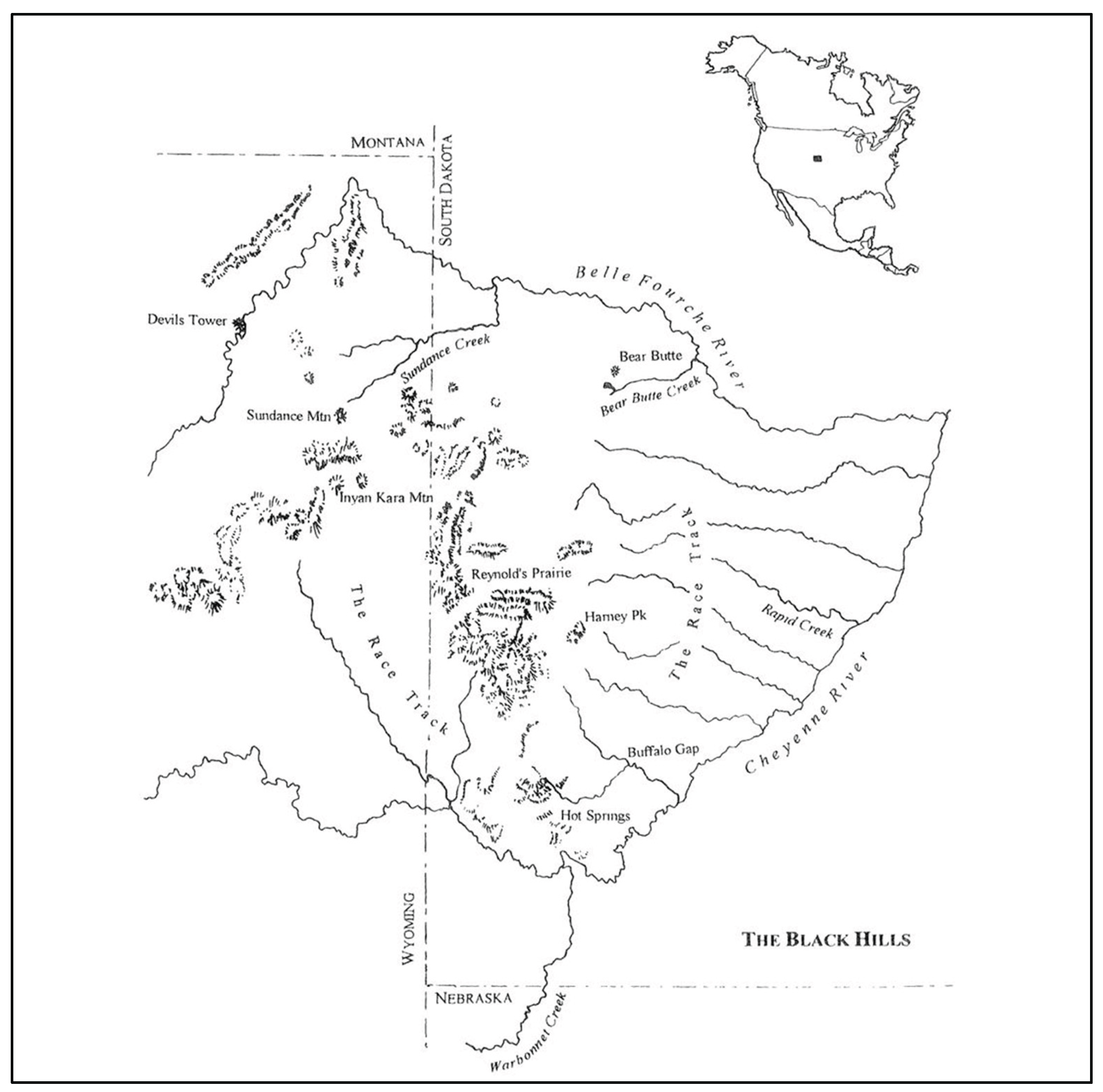
Mateo Tepe (Figure 4) is a Native American name for a tall and geologically unique geosite. This stone tower rises 1,200 feet above a flat grassland that is bisected by the Belle Furche River. The tower is in an area that has been occupied since time immemorial and has become a sacred site for 23 contemporary Native American tribes. Toponymic debates have occurred since the site was placed on official USA maps regarding whether it should be recognized by a Native name such as Mateo Tepe and which translates into Stairs to Heaven. Alternatively, Settler Colonial peoples preferred to call it Devils Tower and see it as representing steps into the Earth to Hell itself30. The struggle over place name began soon after it was mapped in 1875 by a USA military exploring expedition and continues unabated today.
Although the toponymic dispute began in 1875, it has been addressed in various ways by both the public and land managers, including the occasional use of the Native name Mateo Tepe. This is seen on a tourism postcard printed in 1930 (Figure 4).
The U. S. Geological Survey party, who made a reconnaissance of the Black Hills in 1875 called attention to the uniqueness of “The Tower.” Col. Richard I. Dodge, commander of the military escort, described it in the following year as “one of the most remarkable peaks in this or any country.” Henry Newt, geological assistant to the expedition, wrote: "The Tower’s remarkable in structure and symmetry, and its prominence makes an unfailing object of wonder. It is a great remarkable obelisk of trachyte, with a columnar structure, giving it a vertically striated appearance, and it rises 625 feed almost perpendicular (sic)”31
Linea Sundstrom wrote an analysis of the multiple dimensions of the Native concept that argues Mateo Tepe (Figure 5) is a portion of a Mirror of Heaven reflecting and duplicating the Black Hills -- now South Dakota32. Sundstrom drew a simple map (Figure 1.6) to represent the findings of her ethnographically based two-dimensional mirror analysis. Native people stipulate that the heavenly (a Western term) portion of the mirror is exactly like the physical earth toponymic landscape. Spiritual and human activities occur on both dimensions.
One of the many stories about Mateo Tepe’s sacred purpose is when the Spiritual Being known as White Buffalo Calf Woman (Ptecincala Ska Wakan in the Sioux Language) walked down the stairs and then traveled to the pipestone quarries. There, she met with Native spiritual leaders33 and taught them how to properly quarry the red stone and how to make a sacred pipe. From that time on, a pipe made from this red stone was used in ceremonies throughout North America. The smoke from the red pipe rises to heaven and carries prayers to the Creator. After she gave the Sacred Pipe to Native people, White Buffalo Calf Woman returned to the upper dimension and her minor image, the White Buffalo Calf, remained in this dimension. The region surrounding Pipestone has been documented by archaeology as up to 9,000 YBP34. For at least the past 3,000 years, Native people used the Pipestone quarries as a sacred gathering place and the red stone pipes in prayers for the elements of the Earth, including people34. The Pipestone Quarry is currently managed as a National Monument by the USA NPS35.
Figure 6.
Sundstrom’s Map Represents Her Research Findings32.
Devils Tower was declared the first USA National Monument because of its geological value, but it is also now recognized for its Native American value. Mateo Tepe was nominated to and subsequently placed on the Second 100 IUGS Geological Heritage Sites. International Union of Geological Sciences officially defined it as one of the most important geosites in the World36. Mateo Tepe, aka Devils Tower, was jointly named in the IUGS report (as Heritage Site #148 on page 134) and was nominated as both a geologically significant place and a cultural place of importance to Native American tribes36 (Stoffle et al. 2025). Using both Toponyms, this geosite was almost uniquely awarded a position as Site #444 on the official lists of significant World Sites by the Inte national Commission on Geological Heritage Sites (IUGS 2025).
2.1.3. Geoscape Three - Old Spanish Trail: Theme: Lingering Animosity between Native and Settler Colonial Peoples
The Old Spanish Trail (OST) has been designated as a National Historic Trail by the National Park Service and is managed as such by the National Trails System in Sante Fe, New Mexico. The OST existed as a designated USA historic trail for most of a generation before its inherent toponym controversies threatened its continuation.
The Old Spanish Trail became the fifteenth National Historic Trail after Congress adopted Senate Bill No. 1946 and President George W. Bush signed the legislation in December 2002. The three alternatives of the trail occupy 2,700 miles of traditional Native lands. The Bureau of Land Management and the National Park Service administer the trail together to foster trail preservation and public use. These agencies work in close partnership with the Old Spanish Trail Association (Old Spanish Trail Association 2025), American Indian tribes, state, county, and municipal governmental agencies, private landowners, nonprofit heritage conservation groups, and many other organizations.
The Intermountain Regional Office of the National Park Service funded two OST ethnographic studies37,38. The first study involved Native nations that traditionally lived along the trail, and the second involved Hispanic communities that were developed along the trail. Both Native and Hispanic communities were perceived to have been impacted by the caravans of thousands of animals and people who traveled along the OST from New Mexico to California. Once the connection of Native trails was understood after 1849 it became a part of USA national territory, and many kinds of travelers used the trail for various purposes.
Our studies conclude that the U.S.A. National Historic Trail called the Old Spanish Trail (OST) has been incorrectly named and wrongly located by small communities, states, and the U.S. Federal Government. The current toponym OST refers to 3 distinct trails that span about 1,200 miles, involve 40,000 years of use to connect settlements in northern New Mexico and Southern California. Traditional Native trails were used by them to travel for ceremony and resource exchange throughout the southwestern and western North America. Some combination of these traditional foot paths was used since Time Immemorial for both nearby and geographically extensive journeys.
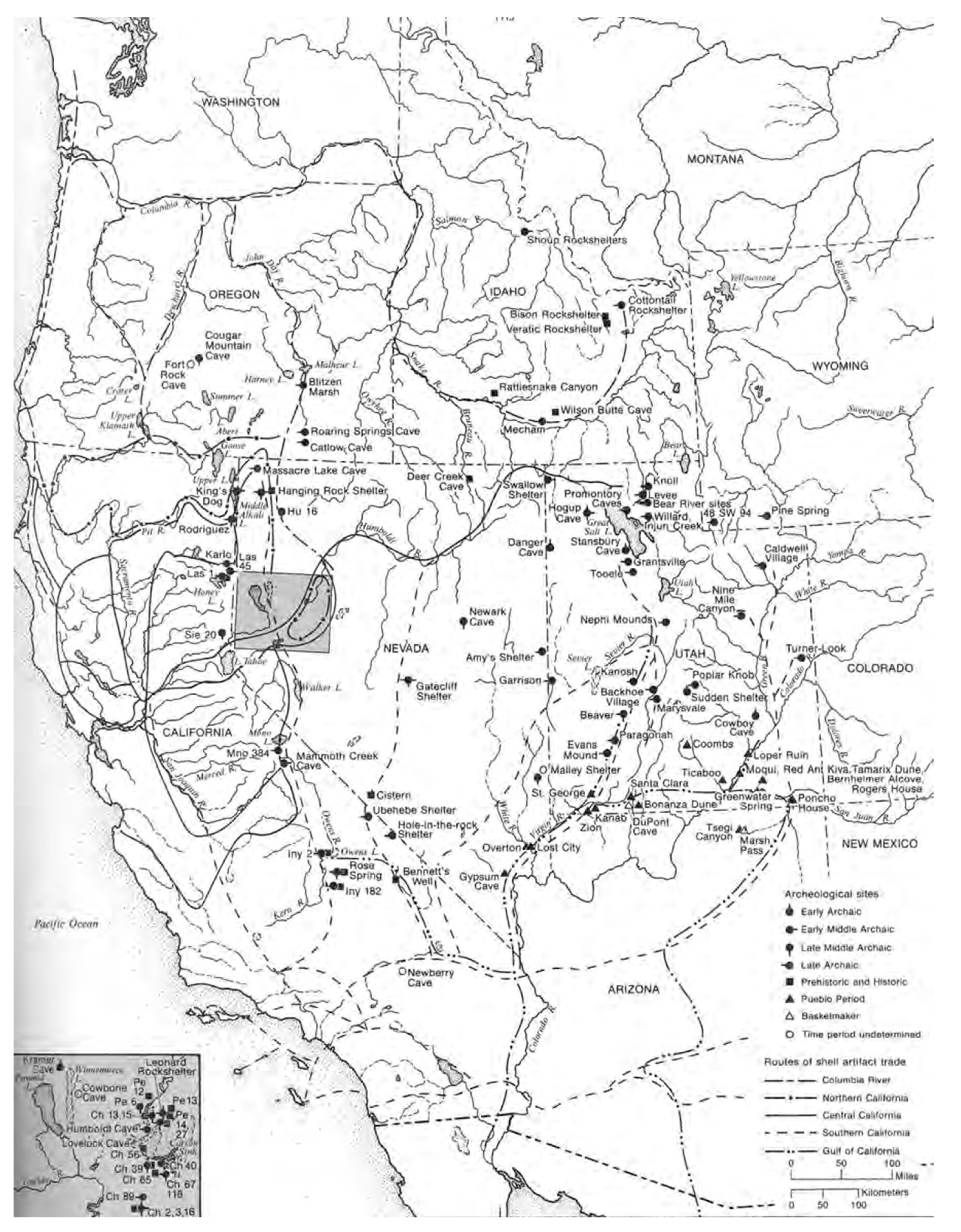
Native people who aboriginally residing in California and New Mexico mutually interacted using geographically diverse and ancient footpaths to share ideas, participate in joint ceremonies, and exchange natural and cultural resources. Some of the foot paths these Native people used are understood as components of the network of trails related to the OST and thus constitute a heritage geotrail system, which is related to various historic events as well as having ancient Native ties. Hopi, Paiute, and Zuni oral history, officially shared during ethnographic studies describes regular travel from New Mexico and Arizona to California (Figure 7). One primary destination point for the New Mexico travelers was Chumash aboriginal communities along the coast of the Pacific Ocean. During these visits ceremonies exchanges were made involving red paint and turquoise from the Colorado River and Grand Canyon and special kinds of obsidian from various Great Basin and Colorado Plateau locations. Ceremonies were jointly conducted to share, abalone and other shells. Ocean water was splashed by water, provided by pueblo pilgrims, towards their eastern agricultural communities to cause rain to fall back home, and ocean water was collected in pitch pine covered woven water bottles to be carried home for ceremonies.
Figure 7.
Old Spanish Trail National Historic Trail39.
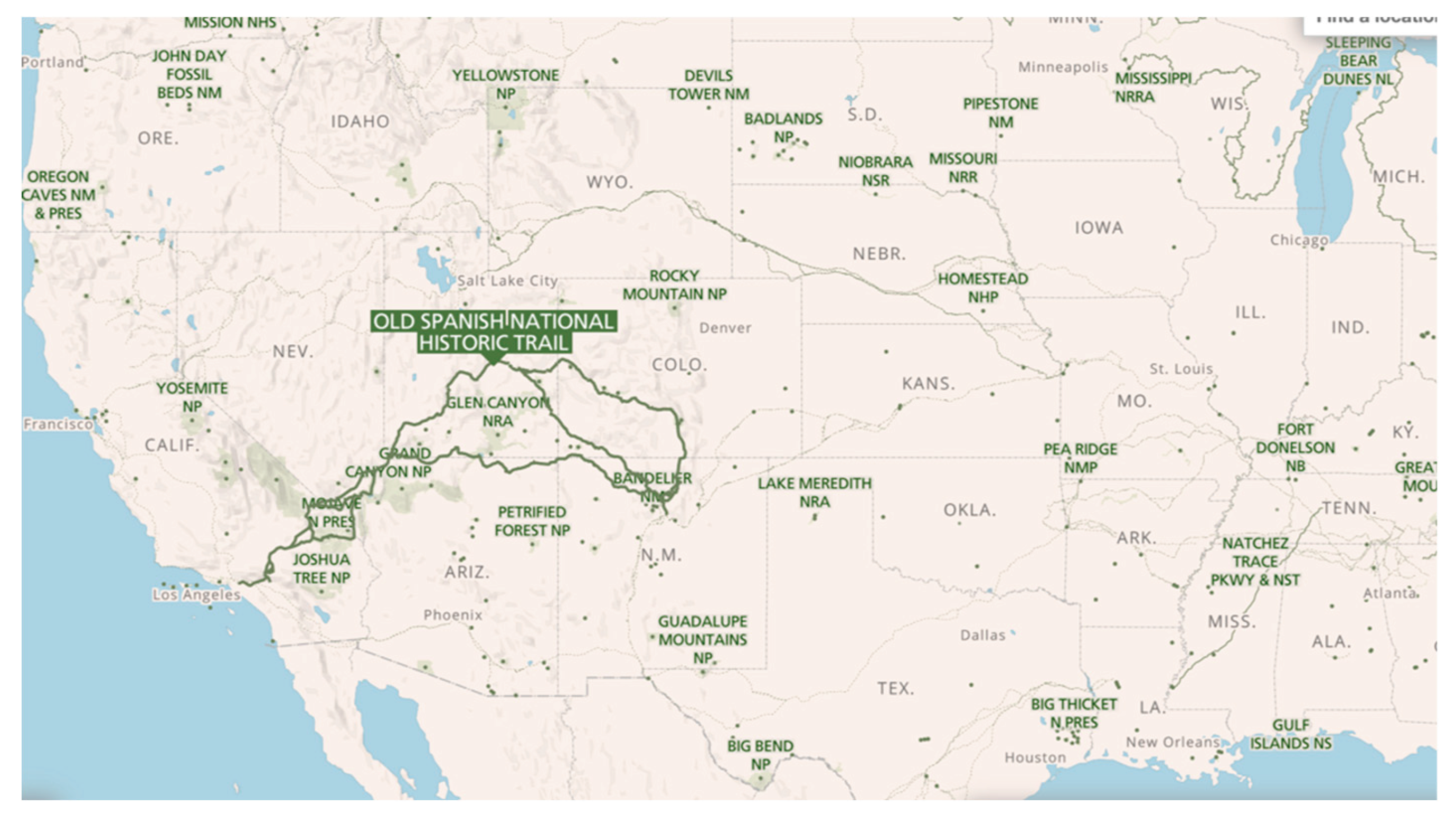
Figure 8.
Shell Artifact Distribution, Major Sites, and Exchange Routes throughout the Great Basin40.
Figure 8.
Shell Artifact Distribution, Major Sites, and Exchange Routes throughout the Great Basin40.
One geosite along these travel areas is called today by a translation of the Native name Ocean Woman who is a Creator Being for Paiutes41,42. It can be assumed that some of the joint ceremonies focused on her and some of these involved thanks for Creation and hopes for cultural and natural balance43–46 special cultural connection between Old Woman Mountains (aka Mamapukaib) (Figure 9)
This geosite exists as a central cultural feature within the Chemehuevi Paiute geography community47. Ocean Woman the Spiritual Being created Mamapukaib and infused this place with spiritual power during Origin Times42. Many ancient trails to this geosite were used by pilgrims to conduct ceremonies which was a Creation purpose for Mamapukib (Old Woman Mountains) which became a destination for such journeys.
Since about 1680 the Native foot path trail networks that involves the OST has changed in use, location, and condition. It has been influenced by the Native horses especially after the Pueblo Revolt of 1680, annual Mexican government sponsored caravans from 1824 to 1848 involving thousands of animals, and hundreds of unregulated wagon trains stimulated by the discovery of gold in the new west coast lands now called California. This analysis is based on more than a hundred OST ethnographic interviews conducted with members of contemporary Native and Hispanic communities located on one or more versions of the evolving trail system.
2.1.4. Cultural Meaning of Native Foot Trails
For more than 40,000 YBP Indigenous people made foot trails that traversed wherever they lived. Their ancestors maintain these trails were designed with a purpose other than simple movement and connected places needing since Creation to be visited and celebrated. Consequently, their ancestors maintain that traditional trails are themselves alive, contain places necessary for ceremony, and remember songs and events that have occurred along their length. Travelers engage the trails, places for ceremony, and each other to create a cultural bond15. The living land can be talked with just as appropriate for interacting with a person48. The land traversed and the trails across it and other dimensions of space and time that are linked to it are sacred living beings9,32,49,50.
Scholars of indigenous trails and the people who made them largely conclude that there is a relationship between journey and identity51. Travelers engage with each other, nature and the supernatural52. Travelers learn landscape knowledge and the inscription of knowledge through symbols and stories14. Behavior and memory contribute to the formation of identities by generating “place-worlds” that people come to identify as their own. Basso11 maintains that place making is a way of constructing the past; that is, the place-worlds we imagine.
Indigenous trails are often for movement from home to spiritual places and people doing this are often called pilgrims53. These link geosites made at Creation to define both the path and the purpose of the journey50. Understanding the relationships between people and their environment is fundamental to understanding the cultural logic involved in ritual performances like pilgrimage30. Turner54 is credited with the concept of communitas, wherein pilgrims during a liminal state bond together with other travelers and with destination places53. Pilgrimages are important to a society’s cultural connections to the local environment, and the incorporation of pilgrimage into ritual sequences affirms the collective valuation of particular places and the social memories inscribed in the landscape55. When pilgrims developed communitas relationships with people and places, both are socially reconceptualized in ways fitting the liminal experience. Simply put, a new social construct will be formed that redefines people and places who have been together in a pilgrimage.
2.1.5. Contemporary Native Trail Networks
Native foot trails today. Some footpaths remain albeit without Native use, cleaning, and prayers such as they received by traditional Native Americans before Euromericans arrived with their animals and new destinations. Figure 10 is a photo of a traditional foot path today in the Mojave Desert as it was being mapped by two archaeologists.
The archaeology study was focused on possible trails connected with the Salt Song and Bird Song funeral paths. The 1981 photo is towards the east looking at Mopah Spring in the Turtle Mountains where the trail winds down the mountain toward the Colorado River. Native epistemology maintains that this and other ancient foot trails were established by various beings57,58.
2.1.6. Trail Network Over Time Periods
There is no evidence that Spanish settlers in either California or New Mexico regularly traveled or even were aware of these OST trails in the Mojave Desert. The ancient network of trails in the Mojave Desert was generally obliterated by Mexican caravans between 1824 and 1848. After this time the rapid movement of massive wagon-trains of gold seekers called the 49-ers moved from many places in the eastern Unites State to California. Their travel established new trails and further obliterating remnants of both the Native trails and the subsequently establish Mexican caravan trails.
This analysis argues that the Native foot paths or trails used initially by the Spanish to arrive from New Mexico to California were either irreparably demolished by subsequent animal hooves or the route was shifted from its original Native trail footprint to other areas. Displacement through violence and disease of the local Native populations who made and maintained the Native trails for thousands of years precluding their restoring damaged portions of the foot trails which were initially used by the Spanish.
The following are some key times when the Native foot trails were either used, demolished, or no longer a part of Spanish, Mexican or US citizen travels between New Mexico and California. Some Native use of some portions of these foot trails were reestablished when non-Native travelers shifted elsewhere.
Post 40,000 YBP Native Period
Originally for thousands of years an integrated series of foot trails used for ceremony, pilgrimages, and trade by Native peoples. It was maintained as a sacred trail and celebrated as a living spiritual identity.
Post 1600 Spanish Colonial Period
After early AD1600 the trails came under the colonial ownership of Spain. The Native revolt against Spanish settlers in 1680 resulted in most of their domestic animals being released and incorporated into Native communities After this time some Native tribes such as the Utes became predominately horse travelers and traders causing the trails to be widened but they largely remaining in their traditional place.
Post 1780 Depopulation
After diseases reduced the numbers and power of the Ute people largely after 1780 AD others began using the trails. During this period however these were foot and horse trails.
Post 1822 - 1848 Mexican National Period
The Mexican revolution against Spain, from 1811 to 1822 AD, Spanish colonial power ended along with their trail use agreement with Natives. After this time the Mexican government officially permitted national trade to encroach on the trails by massive mule and horse caravans which transported New Mexico woolen goods to California and returned with thousands of mules and horses. Massive damage to the trails traveled occurred, however, many traditional trail segments were no longer used by the fast-moving caravans, so they made their own paths.
Wild horses were observed in large herds near the OST by Fremont in 1844. Such herds could move anywhere but certainly traveled along common paths to and from water and shelter. As foot trail travelers these herds would have damaged the traditional trails.
Post 1849 United States of American Period
The Treaty of Guadalupe Hildalgo ended the Mexican - American war and 55% of the Republic of Mexican National territory was ceded to the USA, including the trails. This treaty corresponded with the discovery of gold in newly renamed Mexican State (1824 AD) of Alto California. The massive rush of treasure seekers largely moving where they wished organized into large wagon trains involving hundreds of support animals. Little of the location or structure of the trails survived the movement of thousands of what would be called in American History the Forty-Niners Wagon Trains.
During the NPS funded OST studies all participating tribes and pueblos disputed the USA designated name Old Spanish Trail for a celebrated national trail that they maintained was a series of traditional Native trails that were linked together for Spanish and then Mexican trade caravans. The government of the Taos Pueblo in New Mexico was so incensed by the USA toponym that they refused to participate in the NPS study, even though the activities and events occurring along the OST were key in Taos Pueblo history. They maintained it was always a network of Native trails.
Controversy about the toponym also occurred because the primary use of the OST from New Mexico to California occurred between 1821 and 1849. This was after the Mexican Revolution, which occurred from 1811 to 1821. The OST was not established as a major trade trail during the Mexican National period. After 1849 it became a portion of the USA national territory primarily used for travel by USA colonial settlers seeking gold in California and not Mexican caravans moving woolen products from New Mexico and large mule herds back from California.
Neither the Spanish Colonial government nor the Mexican National government made the OST trail system, which was rapidly modified in size and location after 1849 by the USA gold-seeking settler pack trains and wagons. The toponym OST was simply historically and culturally incorrect. Subsequently, the toponyms for places along the OST were defined in terms of both people and events from these different periods, including Native toponyms.
So even the toponym name Old Spanish Trails carries controversy. As a result, the OST has now been officially surrounded by other larger US National trails which clearly are a part of USA colonial expansion history59. These more recently established national trails diminish both attention to controversy and thus mask OST public debates. The California National Historic Trail is now celebrated as the route of the 1849 gold rush travelers, when in fact initially occurred along or near the OST. So, the history of USA Settler Colonialism has been geographically and temporally shifted.
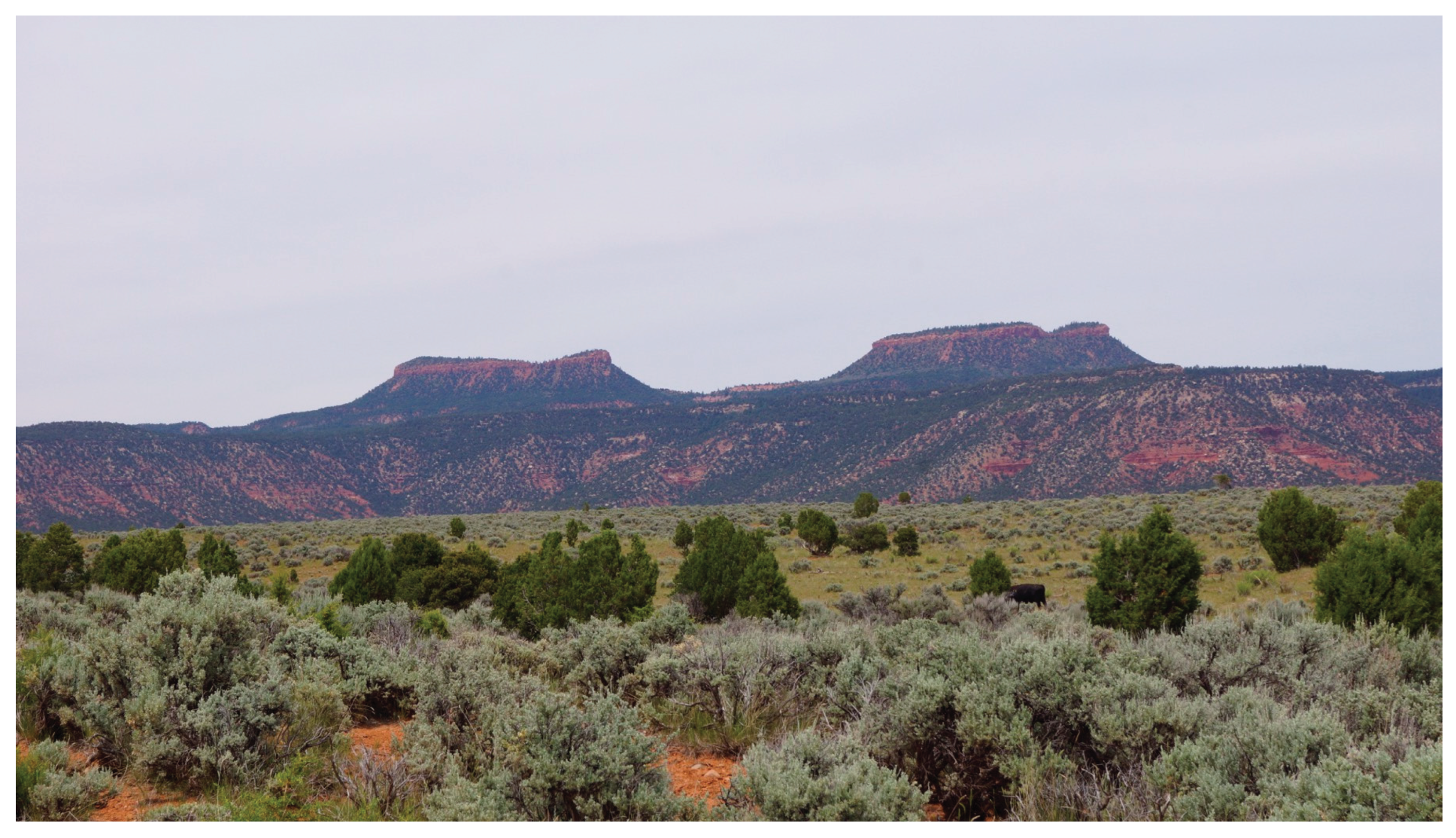
2.1.7. Geoscape Four: Bears Ears, Utah Theme: Multivocality and Many Place Names
The goal of this case is to document multiple cultural connections to two buttes referred to as Bears Ears (Figure 7). Bears Ears is two buttes that sit on the northern portion of Cedar Mesa just south of Elk Ridge and to the west of the Abajo Mountains and a southern portion called Cedar Meas. The rain and snow water flow from the buttes into the surrounding Colorado River and the San Juan River.
Figure 11.
Bears Ears.
The Bears Ears Geoscape extends well beyond the boundaries of BLM and USFS jurisdiction. This landscape has physical geological boundaries that correspond with the region’s major hydrological and key geological features. This geoscape is bounded by the Colorado River to the west, the San Juan River in the south, Indian Creek in the north, and Montezuma and Coalbeds Creek in the east60,61. These hydrological systems are fed by water flow from the surrounding sky islands like the Abajo Mountains and Elk Ridge and mesas such as Cedar Mesa. Importantly water flows from the Bears Ears Buttes to feed the streams the flow into the Colorado and San Juan Rivers.
Culturally, the Bears Ears Geoscape is composed of well over 1000 known archaeological sites and it can be argued that it is the western reaches of the Mesa Verde World. This lifeway was developed during in 800-year period (AD 500 to AD 1300) to describe the rise of peak agriculture in what is now the Four-Corners region of the United States. This lifeway was built on a horticultural economy that over time improved dryland and irrigated farming techniques, increased population growth, and evolving social complexity. During this time, there were large ceremonial centers with groups of kivas and community dancing grounds, would be concentrate under the guidance of religious leaders to perform ceremonial activities such as rain making ceremonies. These ceremonial centers include places like Monarch and Coalbeds. Places like Bears Ears and neighboring present day Natural Bridges National Monument have always been places associated with pilgrimage, ceremony, and Creation.
While the 32 contemporary tribes have different and layered connections to this geoscape, they recognize that each tribe has a cultural right to speak on their connections and traditional uses. Aside from the two BLM funded tribal studies, there is the legally mandated Bears Ears Commission which consists of 5 tribes, Hopi, Navajo, the Ute Indian Tribe, Ute Mountain Ute Tribe, and Zuni. This commission was founded when President Obama signed his proclamation on December 26, 2016. According to the proclamation (Obama 2016), “Bears Ears Commission (Commission) is hereby established to provide guidance and recommendations on the development and implementation of management plans and on management of the monument.” Prior to the formation of the Commission, these five tribes formed the Bears Ears Inter-Tribal Coalition. This group has appointed delegates to represent the tribes’ inherent rights to self-determination, and the coalition works to serve as extensions of each tribe’s sovereign authority as they advocate the protection and preservation of the Bears Ears cultural landscape.
Although a number of colonial toponyms are used today to refer to these three portions of the Bears Ears, from a Native perspective its geology, hydrology, biotic ecosystem, cultural history, and spiritual places are all functionally integrated into an ancient sacred landscape. While this geoscape is known by its colonial name, Bears Ears, the 32 tribes have their own name for this landscape in their own language. For example, the Hopi refer to it as Hoon’Naqvut, the Navajo call it Shash Jaa,’ the Utes named it Kwiyagatu Nukavachi, and for Zuni it is Ansh An Lashokdiwe. Recently, researchers from Northern Arizona University and Heritage Lands Collective conducted an ethnographic study with nine of the culturally affiliated tribes in which tribal representatives shared their deep time attachments to this region.
Native people stipulate that they live in and cultural integrated Bears Ears since Time Immemorial, which archaeologically has been documented to be about 40,000 YBP. Ethnographic studies document how Native groups have utilized the range of natural and ethnographic resources that occur within this complex landscape.
All portions of Bears Ears Geoscape (Figure 12) contain Native toponyms, however the ones occurring in the southern area have become most famous for their diversity and use. These include the stone bridges in Natural Bridges National Moment and large traditional communities which are characteristic of the Western Mesa Verde World. The following are two examples of the geosites located with the larger Geoscape and that were also visited during the current Native American ethnographic study.
Coalbeds Geosite
The Coal Beds geosite was visited during the ethnographic study due its high density of archaeological resources such as rock peckings and paintings, potsherds, lithics, and evidence of a number of stone structures. Coalbeds is located at the junction of two hydrological systems, Montezuma Creek and Coalbeds Creek. The geosite is largely comprised of two sections. One is a flat area with erected stone pillars and remains of a stone structure. The stone pillars stand in a linear alignment (Figure 13 and Figure 14) and face an angled structure remains that are on the edge of the elevated area. This alignment was interrupted to be associated with time keeping and ceremony associated with agriculture.
Rock paintings and peckings are found along the wall of the upper portion of the site and a large freestanding rock. The freestanding rock is a striking feature in this study area because of its size and the number of peckings placed on it. This includes linear designs and spirals along with anthropomorphic figures. Near the peckings were pottery pieces including those of black on white pottery and corrugated pottery were found on the southwest side of the hill towards its bottom.
Monarch Geosite
As part of the Butler Wash hydrological system, Monarch feeds into Butler Wash, along with Comb Wash and ultimately into the San Juan River. The Monarch Study Area is not only an important place for archaeological resources, but it is an also an important area for ethnobotanical resources as well such as Four Wing saltbush, shadscale, Indian ricegrass, globemallow, Indian Tea, and snakeweed. During the ethnographic study, tribal representatives saw Monarch as a place of ceremony, medicine, and clan migration.
The Monarch Geosite is centered around a large alcove with a stone structure, a spring, and a wide array of cultural and natural resources such as petroglyphs and grinding area and traditional use plants. The closest archaeological resources visible as one enters the alcove area after climbing the slickrock slope are petroglyphs. On the wall of the alcove are peckings of anthropomorphic figures and geometric lines which includes pecked images of transformed shamans (Figure 15). These images show how religious specialists have used Monarch as a portal to travel to inversed dimensions of the universe to acquire knowledge, songs, and power (Van Vlack, Arnold, and Bell 2025).
The stone masonry structure remains is one of the most noticeable features available in this geosite and is found in the innermost part of the alcove (Figure 16). The remains are largely comprised of two units. One unit is a detached, rectangular remain with straight walls. The other surrounds a larger space with straight walls and remains of round towers that have intermittent squared holes on their curved walls.
2.1.8. Geoscape Five Iliamna Lake (Nanvarpak, Nila Vena) Native and Local Place Names, Alaska (Theme: Trust and Name Complexity)
This toponym analysis is based on an extended ethnographic and linguistic study by Yoko Kugo, an ethnographer at the University of Alaska. It is focused Native toponyms associated with a very large lake (Figure 17) (a geosite) and the numerous associated geosites that constitute its massive integrated surrounding geoscape62–67. Iliamna Lake, which is the largest freshwater lake in Alaska, lies 362 km (225 mi) southwest of Anchorage, in southwest Alaska. Today, five communities lie on the shores of the lake: (1) Pedro Bay, Iliamna, (2) Newhalen, (3) Kokhanok, and (4) Igiugig. The people of Levelock, a community on the Kvichak River, have close ties to the Iliamna Lake communities. Some residents of these communities have moved around seasonally for commercial fishing, hunting, and through marriage. Because of such travel and migration these communities now include descendants of five cultural groups (1) Dena’ina, (2) Central Yupiit, (3) Sugpiaq (Alutiit), (4) Russians, and (5) northern Europeans. The toponyms surrounding the lake reflect these cultural groups but are dominated by the English language settlers who dominate the production and modification of place names.
Two Native names, Nanvarpak (“big lake” in Yup’ik) and Nila Vena (“islands lake” in Dena’ina) refer to the body of water widely known as Iliamna Lake. Locals recalled the present name “Iliamna” Lake having originated from Russians who modified and recorded the Dena’ina name Nila Vena to Ilyamna (as a Russian place name).
According to Kugo63, place names and associated stories about these places illustrate community histories, lifeways, and cultural ethics and practices that are grounded in people’s intimate relationships with their homeland. During her ethnographic research that took place between 2016 and 2019, Dr. Kugo worked with community elders to document traditional place names and stories. This occurred while travelling to these places with community members and participating in harvesting berries and fish. The Elders’ memories about the land and places awaken old connections to the landmarks, streams, lakes, and mountains that have given them life, food, and shelter. Sharing the place names in these stories and injecting their own experiences into the stories expands the narratives, making them more personal and applicable to the Elders’ own contemporary settlements.
Kugo illustrates how difficult it is to both explain the purpose of research conducted by a cultural and social outsider and still meet the culturally appropriate confidential protocols needed for the study to be successful. The researcher, Dr. Kugo, emphasizes that the Iliamna Lake area is unique because (1) it consists of 2+ Native language groups, (2) it previously had a Russian influence, and (3) it is now in USA territory. Place Names will not completely tell the stories and histories of a cultural people, but as ethnographic researchers, we learn by hearing the stories behind the names. Native local people have passed down their histories and experiences through telling stories about places.
Kugo concludes that Indigenous peoples become aware of sense of place in part by passing down place names with the cultural ethics related to these places, and by living according to these ethics. Telling and retelling stories affirms those people’s confidence and competence in their vernacular knowledge, which allows them to thrive on their homeland. Their cultural landscapes exemplify their traditional ways of life, ecology, and culturally based interactions with the land.
Yupiit people maintain reciprocal relationships between humans and animals, as well as between the spiritual and natural worlds. The Yupiit often relate their practices and ways of harvesting plants, fish, and animals at places when talking about their travel routes and landmarks, thereby ensuring that this traditional knowledge spreads. Yupiit people believe that their practices help the spirits return to the living world, so that the people can hunt the animals again in the future. Hunters leave food offerings to show appreciation to the land and animals63, and people discard animal bones in the water after a meal or bury them where people will not step, as a sign of respect.
The joint place name study has documented more than 219 Iliamna Lake Yup’ik place names67. The location of the Yup’ik place name is primarily referenced using English place names on official maps. Yup’ik people wish to have their language place names also on the official maps. The complexity of using Yup’ik place names to indicate geosites derives from how they talk about these places. Often there is no single term of reference but instead the place is known by special events and location relative to other places.
A further place name study (Kuki 2024) extensively involved committees composed of elders whose desire was to expand recorded knowledge of toponyms for future generations. These two yearlong studies resulted in more than 200 places being better recorded and further studied. For each place, elders provided (1) a Yup’ik name, (2) a literal translation, (3) related Yup’ik words that further define the place, (4) location information using other Yup’ik toponyms, (5) an English name, (6) a second Yup’ik name for the area, (7) literal translation of the 2nd name, (8) more Yup’ik words about the place, (9) another Yup’ik name for place, (10) related Yup’ik words about the place, (11) key topographic features of the place, (12) more location information, (13) English name of nearby location and (14) descriptions of toponym from elder oral interviews. The latter often include stories about the place and related locations. In this expanded report of findings, the typical toponym requires two pages of text to be culturally understood. This text constitutes its minimum name in Yup’ik. Thus, the study explains the difficulty of rendering a Yup’ik toponym as a single place name for a flat map. The Yup’ik people and other Native groups are working with ethnographers and cartographers to produce electronic maps that can contain pages of cultural information about hundreds of toponyms. Such living maps are untended to be used in schools and community centers as well as heritage data bases.
2.1.9. Geoscape Six El Malpais National Monument, New Mexico (Theme: Layered Toponymic Landscapes)
El Malpais National Monument (ELMA) is an ancient area consisting of multiple unique geoscapes; that is, lava flows and volcanoes occurring on top of each other forming layers of volcanic fields (Figure 18 and Figure 19) and underground lava tubes. Today the lava flows are managed as a USA national monument by the US NPS using the area’s original colonial toponym applied during the Spanish Colonial period and continued during the USA colonial period68. El Malpais is a Spanish term for a bad place or bad lands, but the tribes and pueblos who participated in the NPS funded ethnographic study of this lava flow define it using their own linguistic terms and specifying traditional uses of its cultural importance and spiritual places69. Larsson69 writes, The name “El Malpais” (“the badlands”) is a colonial one, showing that the Spanish explorers saw these jagged lava fields as cursed and impassable. However, the Pueblo peoples and Navajo saw them as a meaningful part of their homeland.
The five unique lava flows of the park occurred over a period of thousands of years deriving from the foot of a massive sacred mountain, with the colonial name Mount Taylor. This shared sacred massif has dozens of other Native names and has been the subject of extensive Native heritage research70. All the volcanic landforms in the area were not formed because of a single, catastrophic eruption of Mt. Taylor. The current landscape is a product of a succession of volcanic events extending over a long period of time.
The Mt. Taylor massif and its lava fields are active Native ceremonial areas and are generally considered living geological places involved in the rebirth of the Earth. Archaeologists have recorded native people for 40,000 YBP, potentially meaning that native American people have been observing many of the historical volcanic events. Also, these events might have been remembered into the present through oral history. During the Mt. Taylor Traditional Cultural Property (TCP) studies, 16 tribes were consulted. Between October 2007 and February 2008, formal consultation meetings were held with 8 Native governments, including the Pueblos of Acoma, Laguna, Zuni, Jemez, Isleta, the Hopi Tribe, the Jicarilla Apache Nation, and the Navajo Nation. These Native tribes and pueblos provided the heritage information needed to nominate most of the Mt. Taylor massif to the National Register of Historic Places.
Mount Taylor and its lava fields are active Native ceremonial areas and are generally considered living geological places involved in the rebirth of the Earth. Archaeologists have recorded native people for 40,000 YBP, potentially meaning that native American people have been observing many of the historical volcanic events. Also, these events might have been remembered into the present through oral history. During the Mount Taylor Traditional Cultural Property (TCP) studies, 16 tribes were consulted. Between October 2007 and February 2008, formal consultation meetings were held with 8 Native governments, including the Pueblos of Acoma, Laguna, Zuni, Jemez, Isleta, the Hopi Tribe, the Jicarilla Apache Nation, and the Navajo Nation. These Native tribes and pueblos provided the heritage information needed to nominate most of the Mount Taylor to the National Register of Historic Places.
A shared heritage interpretation is that landscapes are more than the physical environment, or a pictorial representation of natural scenery71–73. In the view of most American Indians, the concept of landscape is not limited to the physical realm of topographic features, stone, trees, and water, but also includes the spiritual world74. Their cultural practices and beliefs reflect a sense of place (emphasis added). Gulliford75 states that “Sacred sites remain integral to tribal histories, religions, and identities” and stresses the importance of “understanding landscapes in the context of traditional Native American religion and the powerful, enduring presence of sacred geography”. Vine Deloria writes that sacred places “are places of overwhelming holiness where the Higher Powers, on their own initiative, have revealed themselves to human beings…This tradition tells us that there are places of unquestionable, inherent sacredness on this earth, sites that are holy in and of themselves.”75
From the surface of the lava flows and emerging volcanos the ELMA lands are sacred and have always been. For example, Kipukas were formed during the flows of lava. During their movement they picked up preexisting earth and carried it along with the flowing lava. When the flowing lava came to a stop islands of preexisting earth now occurred throughout the lava landscape. These dirt islands are now called by the Hawaiian name Kipuka. The islands at ELMA became culturally special and the focus of ceremonial activities. They were connected by laboriously constructed trails from the edges of the lava flow.
Park archaeologists have mapped a system of trails across the most recent of the lava flow and identified that some of these connect the Kipukas with places elsewhere in the lava field and along its edge (Figure 20 and Figure 21). In Figure 21, the trails are marked in yellow and the structures on the Kipukas are indicated by red squares.
Below the surface of the lava flows are tubes (Figure 22) that define this as a volcanic layered landscape. Lava tube formation and layers: tubes are built up by layers of successive lava flows. There are examples in the monument of stacked lava tubes. A succession of flow events has caused the tubes to be stacked on top of each other. There are several in the Bandera flow and the tube at the base of McCarty’s Crater.
One lava tube, called Sheep Trap, is open at two ends, creating a very short dark zone. One end has a ramp (naturally occurring but humanly enhanced), and the other end is a barricade built by people. Bighorn bones have been found around the barricade76 (Windes 2008). At one end there is a bighorn sheep bone, a wall of breakdown from the tube roof, and tree logs designed to trap the animals.
Many species of invertebrates live in the lava tubes. Moss gardens have the highest diversity. Bats roost and raise young in the tubes during the summer, and several species (perhaps 10 to 12) overwinter in the tubes through hibernation. Other animals enter the lava tubes probably for water in the late spring to early summer, when surface water is lowest and seasonal ice melts. Ringtail cats often frequent lava tubes hunting bats – this is a good reason to roost on the ceiling.
Many species of invertebrates live in the lava tubes. Moss gardens have the highest diversity. Bats roost and raise young in the tubes during the summer, and several species (perhaps 10 to 12) overwinter in the tubes through hibernation. Other animals enter the lava tubes probably for water in the late spring to early summer, when surface water is lowest and seasonal ice melts. Ringtail cats frequently visit the lava tubes to hunt bats, which is a good reason for the bats to roost on the ceiling.
The remains of other animals such as deer, elk, bighorn, bobcat, and wolf have been found in the lava tubes. These remains were likely brought into the lava tubes by people. There are many examples of this kind of activity in several of the lava tubes throughout the monument. Usually, the remains are partial skeletons. There are a few examples of complete skeletons, one example being a bighorn in Braided Cave. Another is an elk and a bobcat in Pantheon Cave (Figure 23). It is conceivable that the bighorn walked into Braided Cave and died. The remains in Pantheon are harder to explain and are quite old - ca. 2700 BP. They are far at the back of the cave in a dark zone. The only access to the cave is a 40-foot drop at the entry. So far, samples have not identified cut marks or indications of predation on the bone. The presence of faunal remains deep in the caves is a puzzle. A few examples of bone could be explained, but there are many examples- hundreds of bones such that it logically suggests human activity and use.
ELMA offers a telling example of how toponyms can encapsulate competing epistemologies of places. For the Acoma, Zuni, Laguna, and Navajo peoples, the volcanic flows, cinder cones, and ice caves that characterize the area are integral components of a sacred geography, animated through origin narratives, ceremonial practices, and kin-based relationships with the land. In these Indigenous epistemologies, El Malpais is not an inert “landform” but a living participant in a network of spiritual, historical, and ecological relations that sustain community identity and cosmological order. The Spanish Colonial name El Malpais—literally “the badlands”—embodies an external, utilitarian gaze that interprets the jagged lava fields as barren, dangerous, and without value for cultivation or settlement. This linguistic imposition not only erases Indigenous place names but also encodes a worldview in which landscapes are assessed in terms of economic productivity rather than spiritual significance. The juxtaposition of these naming systems highlights the role of toponyms as sites of epistemological contestation, where colonial descriptors overwrite Indigenous narratives, yet Indigenous place-based knowledge continues to assert alternative ontologies grounded in long-standing reciprocal relationships with the land.
3. Case Discussions
This analysis highlights field-based ethnographic findings about geological toponyms, especially as these are involved disputes in cross cultural environmental communications about the identification, interpretation, and management of places. Some of these issues are listed below with highlighted key issues and one reference.
- Debates over geological toponyms are intensely argued because these places represent important aspects of past and contemporary heritage for different peoples (O. Viteri 2017).
- Resolution of toponym debates is difficult, but a middle ground resolution often can be achieved through multivocality77.
- Multivocal presentations use limited communication space, which reduces the ability of the debating cultural groups and land management agencies to convey toponym interpretations78. Reduction in space and increased complexity of message can result in the further essentialization of places. You can only get so much information into an interpretative sign, ranger talk for tourists, or brochure79.
- Epistemological divides are dimensions of geological toponyms that can cause debates to be unresolvable. People hold beliefs called ultimate sacred postulates about the world that are not logically possible in other cultures14.
- Geological places often are understood by culturally affiliated Native peoples as being alive, either as living beings themselves or composed of living beings. The Living Universe is a stipulated belief for most Native peoples1.
- A key finding from our five ethnographic studies is that places are culturally layered with different meanings, each of which are specific to the peoples who have interrelated with the geosite for long periods. For Native people of the southwestern USA this relational period is about 40,000 YBP. Deep time and multicultural connections make for complex understandings of places. This complexity becomes a key issue when Native people participate in land management meetings where their desire to maintain or reapply traditional toponyms face resistant from supporters of colonial toponym meanings.
- Some Native cultures maintain that sacred toponyms should not even be approached until they understand your purpose and approve your requests15.
4. Toponyms
The naming, (re)naming, and not naming of places is purposeful because when people live in an environment, they incorporate it into the sense of personal, family, community, and ethnic identity. Native people talk about places that count80 in terms of what wisdom11 they hold and can share to bring balance into the world and to center people in their history. Many Native places involve stories about what the place was intended to be at Creation and what it can become for further generations. Most Native people use their own terms of reference for places knowing that other cultural groups will have their own ways of talking about and to these places. The energy and spirituality of places are shared broadly among Native peoples. Places can be very site-specific locations; however, most are known through the broader areas where they are located. For Native Americans and many other indigenous peoples, the cultural meanings of places are primarily defined at Creation, although some can be understood by events that have occurred there.
Colonial toponym actions often began as a symbolic planting of the home country flag and declaring the land owned by the royals of that nation. Thus, in colonial culture some and perhaps all toponyms involve ownership of place whereas the opposite was traditionally true of Native places. In general, the more important a place and its associated physical and spiritual resources the more likely it will be peacefully shared by different cultural groups. A few examples of multiethnic sharing are the Zuni Salt Lake, in New Mexico, the Pipestone Quarries, in Minnesota, Mateo Tepe, in Wyoming, and Effigy Mounds, on the junction of the Mississippi and Wisconsin Rivers in Ohio.
USA Presidents have engaged in political disputes by using Toponyms. These actions are value based and politically motivated81. For example, the tallest mountain in North America, which is located in Alaska, has been the subject of repeated name changes by presidents of the USA. Initially the mountain called in 1917 Mount McKinley to honor a USA president.
Figure 24.
Mt Mckinley vs Denali (NPS Denali 2025).
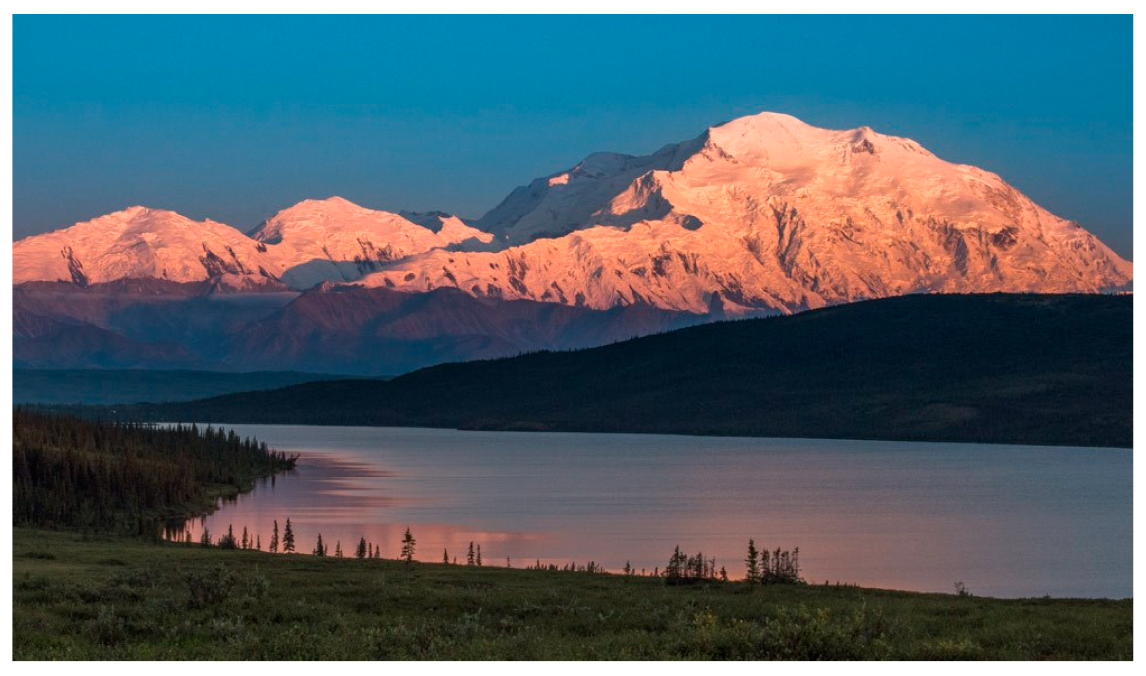
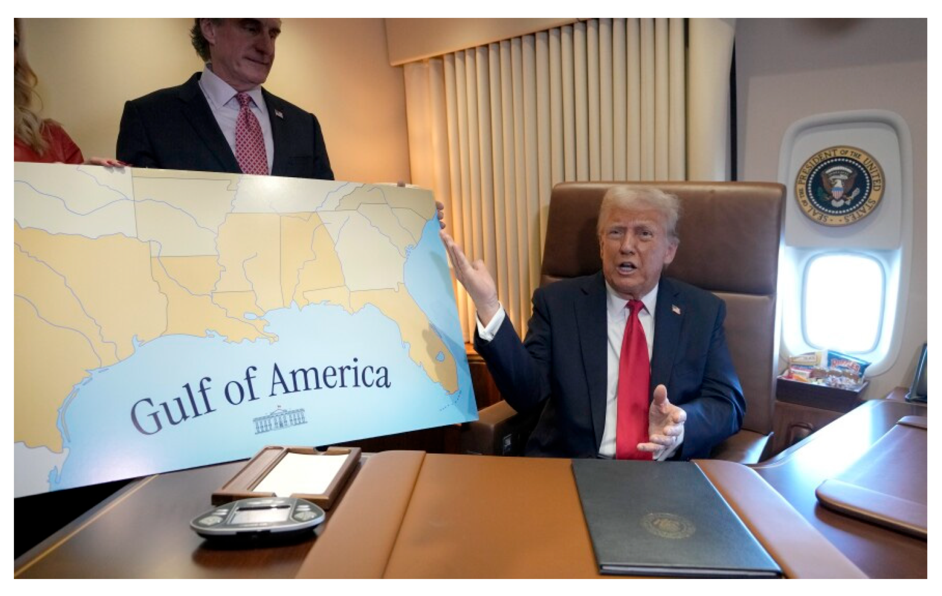
President Obama changed the name in 2015 and called it in a Native language as Denali, which is only one of the Native terms of place reference for the mountain. Then in 2025, Trump renamed it again as Mount McKinley. President Trump changed the historic toponym referencing the massive Gulf of Mexico to the Gulf of America, saying at the signing to reporters that he got teary eyed when he signed the Executive Order changing the name. This is a political process that Bolton82 concluded is a planned social distraction produced by the jingoistic renaming of seas, mountains, and other landmarks, creating an exclusionary national language.
During a meeting between President Trump and President Putin of Russa expressed the importance of Russian heritage in Alaska that was derived from their colonial occupation of these lands. Putin confirmed the continuation of this heritage connection by saying his scholars have identified 700 place names of Russian origin.
Figure 25.
Trump Executive Order Changing the Gulf of Mexico to Gulf of America.
Many geosite toponym disputes in North America are between Native people whose lands are involved in encroachment by members of one or more conquering colonial society(s). Native struggles are focused on returning traditional names to these places and re-establishing aboriginal styles of land management. A key modern assumption regarding (re)naming is “if it has a Native name then Native people have a claim to interpret it and share in its management.”
Native people today, however, also experience conflicts with each other regarding appropriate place terms and even the question of whether to publicly share the traditional reference to cultural places. Conflicts exist among people of a common culture who have difference experiences, producing what Cearns terms a heterotopia struggle83. Both types of debates primarily derive from the western views of property rights to land and the ownership of places, including the right to name the place. Imbedded in these debates is the western notion that a single name can accurately essentialize a place, whereas from a Native perspective places are ancestors who are politely approached and talked with before we use their names.
Native peoples throughout the world have interacted with what they define as significant natural places. Knowing or learning about the Native cultural heritage of places is more than simply interacting with its tangible representations according to the analysis of Lijeblad and Verschuuren84 (2019). The cultural heritage of a place is tied to values, beliefs, ideas, practices, politics and sociocultural meanings. We can only ‘know’ the place when we accept that there can be no separation of the spiritual and the physical. Knowing is entangled through rituals, narratives, and stories.
Returning traditional names to places serves as a symbolic way of replacing colonial rule, but it is also a way to reestablish cultural identity. Loss of traditional identity has resulted in individual and community problems. Reassorting traditional Native names and the return of ceremonies at that location are proven step towards cultural revitalization. Some essential ceremonies can only be conducted at specific places. A Navajo tribal member and a MA student at the University found that many youths were not initiated because the places where such ceremonies traditionally occurred were modified in name and access85. This resulted according to his firsthand consulting in the Navajo Nation that a lack of ceremonial participation is the cultural reason why Navajo youth become involved in harmful behaviors including drugs and suicide. His thesis is that the separation of Navajo people from each other, their lands, and control over their lives diminished the ability of adults to function in positive ways, whether they are living more traditional or acculturate lifestyles. When adults are less than fully functional youth, families, and communities are diminished. The government of the Navajo nation agrees and supports his efforts to reestablish control over special places for both youth and adults who have not gone through traditional ceremonies. His findings were supported by in many ways by research publish in Community Psychology.
5. Multivocality: A Way Forward
The world community of nations and peoples who strive for peaceful cooperation are needed to remove and perhaps heal decades of colonial expansion and the exclusiveness of nationalism. The sharing and appreciation of different cultural understandings is understood as multiculturalism86. It is a path for sharing space in order to celebrate complex alternative cultural understandings. Toponymic multiculturalism often best occurs at natural places where people come to learn about the environment and its various human partners.
Even when the social conditions exist and resources are allocated for multiculturalism, real limitations exist. In the United States, national and state parks educate the public about nature and human relationships more than any other entity. The parks, however, educate within economic, spatial and physical constraints. In the USA, educational displays typically are only changed over a period of decades. Funds to conduct studies like ethnographic overviews and assessments are limited, and so decisions are made to incorporate fewer cultural groups than those who convey an affiliation with the natural resources of a park. Transforming new cultural understandings into active management plans and visitor interpretive materials is expensive, time consuming, and always depends on the cross-cultural understandings of agency personnel.
Sunset Crater National Monument could serve as a model for Bears Ears National Monument and the Monticello Field Office as a way forward. Sunset Crater National Monument conducted ethnographic studies and independent consultations involving culturally affiliated tribes and pueblos, resulting in a rather extensive list of suggestions for ways forward to a more multicultural situation.
The space limits in the visitor center and number of interpretative signs possible resulted in only a fraction of the culturally affiliated tribes and pueblos being represented. Even when toponyms from some of these tribes and pueblos were included in interpretative displays, only a few words were used for a few locations. In the park, a trail sign recognizes eight culturally affiliated tribes and pueblos: (1) Hopi, (2) Zuni, (3) Yavapai, (4) Havasupai, (5) Hualapai, (6) Navajo, (7) Western Apache and (8) Southern Paiute (Figure 1.20). The sign shares a composite Native statement, specific cultural statements from three of the eight tribes, two Hopi painters’ renderings of the volcanic eruption, and a photo of Sunset Crater. This is a major interpretative step for the park but leaves much left to be said.
Figure 26.
Trail Sign at Sunset Crater National Monument.
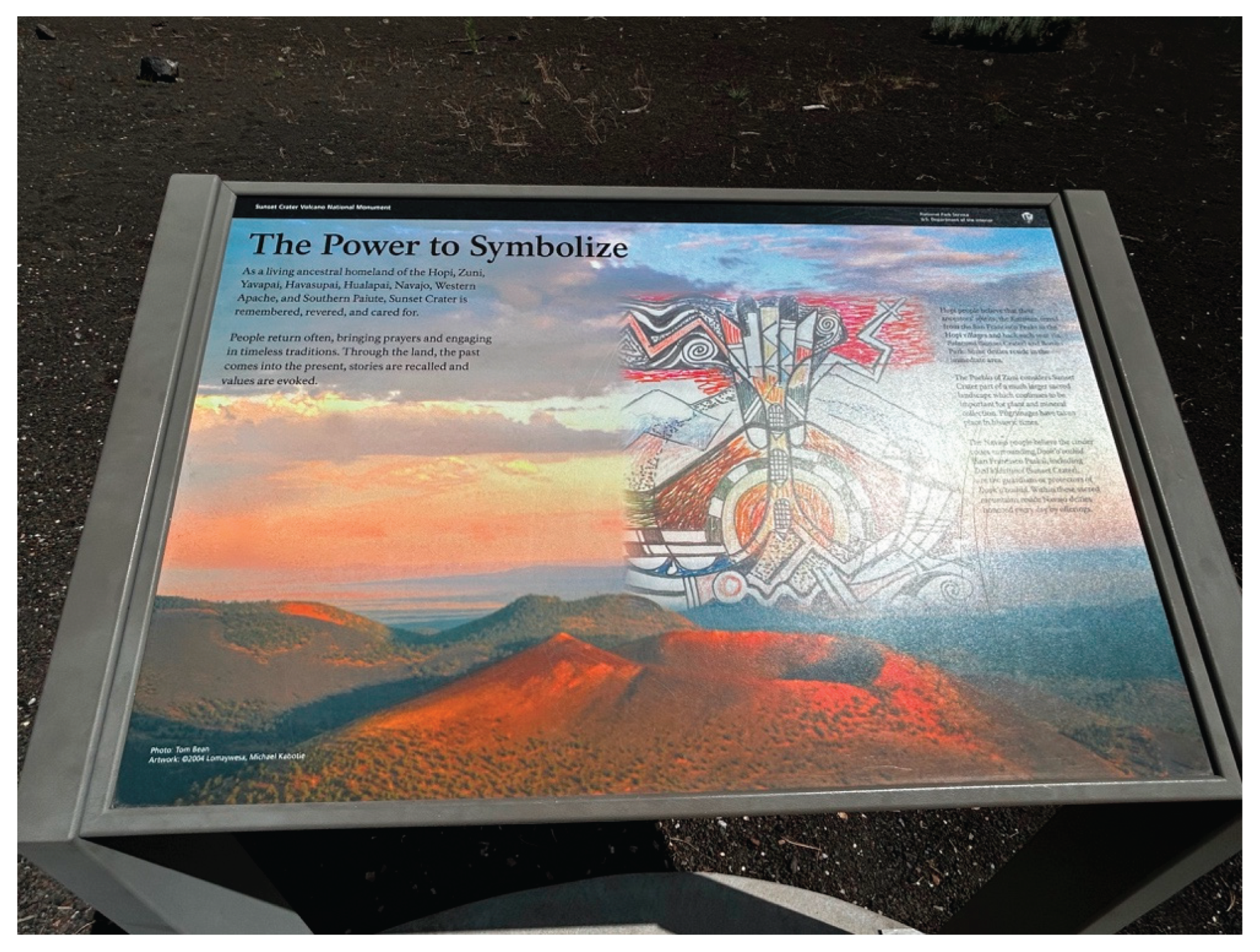
Additionally, inside the visitor center are other displays that include snippets of other tribal histories. Nowhere within the monument is signage displaying a holistic cultural landscape for each of the eight tribes displaying multiple toponyms in their native language. We reference again the Zuni request from the Mount Taylor TCP study for their cultural resources not to be broken into pieces but instead presented as a whole, functionally integrated sacred landscape74.
According to an analysis of heritage issues at geosites19, volcanoes are widely visited globally and are considered potential geosites due their attractiveness87. Therefore, signage in different languages and the presence of specially trained tour guides are necessary88. Our work at Sunset Crater builds on this by suggesting that interpretive guides be versed in Native American perspectives on volcanos and defining Sunset Crater as a geocultural site. We define this concept as where “the geological features interact with cultural elements (historical or archaeological vestiges, cultural or religious monuments, etc.), and the geoheritage value joins the cultural value,”89.
Author Contributions
The authors each participated in the data collection portion of the research, the data analysis, and the writing, and editing of this document.
Funding
Funding for the projects discussed in this manuscript has been provided by the United States federal government, particularly the National Park Service and the Bureau of Land Management.
Data Availability Statement
All data used in this manuscript can be found in publicly available research reports.
Acknowledgments
The authors wish to thank all of the Native American elders who participated in our past studies. Without them this discussion would not be possible. We also would like to thank members of our research team past and present who assisted in data collection.
Conflicts of Interest
The authors declare no conflicts of interest.
References
- Stoffle, R.; Arnold, R.; Bulletts, A. Talking with Nature: Southern Paiute Epistemology and the Double Hermeneutic with a Living Planet. In Collaborative Heritage Management; Tully, G., Ridges, M., Eds.; Gorgias Press: Piscataway, NJ, USA, 2016; pp. 75–100. [Google Scholar]
- Jennings, F. The Invasion of America: Indians, Colonialism, and the Cant of Conquest.; University of North Carolina Press: Chapel Hill, NC, 1976. [Google Scholar]
- Chartrand, V. Settler Research in Indigenous Country. Qualitative Inquiry 2025, 10778004251390015. [Google Scholar] [CrossRef]
- Norgaard, K. M. Salmon and Acorns Feed Our People: Colonialism, Nature, and Social Action; Nature, Society, and Culture; Rutgers University Press, 2019. [Google Scholar]
- Greenberg, J. H. The Doctrine of Discovery as a Doctrine of Domination. JSRNC 2016, 10(2), 236–244. [Google Scholar] [CrossRef]
- Middleton-Manning, B. R.; Reed, K. Eturning the Yurok Forest to the Yurok Tribe: California’s First Tribal Carbon Credit Project. Stanford Environmental Law Journal 2019, 39(71), 71–124. [Google Scholar]
- Sindoni, R.; Blake, D.; McCovey, L.; Carroo, I.; Gormley, J.; Barker, J. Indigenous Circular Economies (IndCE): The Yurok Tribe, Regenerative Forest Management, and Tribal Sovereignty. Center for Open Science 2025. https://osf.io/preprints/socarxiv/jznrf_v1.
- Anthropological Perspectives on Environmental Communication; Sjölander-Lindqvist, A, Murin, I., Dove, M., Eds.; Palgrave: London, 2022. [Google Scholar]
- Stoffle, R.; Arnold, R.; Van Vlack, K. Landscape Is Alive: Nuwuvi Pilgrimage and Power Places in Nevada. Land 2022, 11(8). [Google Scholar] [CrossRef]
- Stoffle, R.; Arnold, R.; Frank., M.; Cornelius, B.; Miller, L.; Charles, J.; Kane, G.; Ruuska, A.; Van Vlack, K. Ethnology of Volcanoes: Quali-Signs and the Cultural Centrality of Self-Voiced Places. In Engineering Mountain Landscapes: An Anthropology of Social Investment; Scheiber, L., Zedeño, M., Eds.; University of Utah Press: Salt Lake City, Utah, USA, 2015; pp. 99–115. [Google Scholar]
- Basso, K. Wisdom Sits in Places: Language and Landscape Among the Western Apache; University of New Mexico: Albuquerque, NM, 1996. [Google Scholar]
- Stoffle, R.; Loendorf, L.; Austin, D.; Bulletts, A.; Fulfrost, B. Tumpituxwinap: Southern Paiute Rock Art in the Colorado River Corridor; University of Arizona: Tucson, AZ, 1995. [Google Scholar]
- Lujan, V. Taos Pueblo Blue Lakes: A Legacy of Cultural Perseverance. In Indigenous Perspectives on Sacred Sites: Culture, Governance and Conservation; Verschuuren, L., Liljeblad, J., Verschuuren, B., Eds.; Routledge: London, 2019; pp. 106–118. [Google Scholar]
- Rappaport, R. A. Ritual and Religion in the Making of Humanity; Cambridge Studies in Social and Cultural Anthropology. Cambridge University Press: Cambridge, 1999. [Google Scholar] [CrossRef]
- Shipek, F. KUUCHAMMA: The Kumeyaay Sacred Mountain. Journal of California and Great Basin Anthropology 1985, 7, 67–74. [Google Scholar]
- Trouillot, M. R. Silencing the Past: Power and the Production of History; Beacon Press books; Beacon Press, 1995. [Google Scholar]
- United Nations. Toponymic Guidelines for Map and Other Editors for International Use. United Nations Group of Experts on Geographic Names. https://unstats.un.org/unsd/geoinfo/ungegn/wgGuidelines.html#:~:text=The%20content%20of%20Toponymic%20Guidelines%20has%20been%20developed%20since%201979,national%20maps%2C%20and%20administrative%20regions.
- United Nations. Ninth United Nations Conference on the Standardization of Geographical Names; United Nations: New York, 2007. [Google Scholar]
- Herrera-Franco, G.; Carrión-Mero, P.; Montalván-Burbano, N.; Caicedo-Potosí, J.; Berrezueta, E. Geoheritage and Geosites: A Bibliometric Analysis and Literature Review. Geosciences 2022, 12(4), 169. [Google Scholar] [CrossRef]
- Muzambiq, S.; Walid, H.; Ganie, T. H.; Hermawan, H. The Importance of Public Education and Interpretation in the Conservation of Toba Caldera Geoheritage. Geoheritage 2021, 13(1), 3. [Google Scholar] [CrossRef]
- Aoulad-Sidi-Mhend, A.; Maaté, A.; Amri, I.; Hlila, R.; Chakiri, S.; Maaté, S.; Martín-Martín, M. The Geological Heritage of the Talassemtane National Park and the Ghomara Coast Natural Area (NW of Morocco). Geoheritage 2019, 11(3), 1005–1025. [Google Scholar] [CrossRef]
- Ghazi, J. M.; Ólafsdóttir, R.; Tongkul, F.; Ghazi, J. M. Geological Features for Geotourism in the Western Part of Sahand Volcano, NW Iran. Geoheritage 2013, 5(1), 23–34. [Google Scholar] [CrossRef]
- Spennemann, D. H. R. A Disappearing Cultural Landscape: The Heritage of German-Style Land Use and Pug-And-Pine Architecture in Australia. Land 2025, 14(8), 1517. [Google Scholar] [CrossRef]
- Stoffle, R. Culture Heritage and Resources. In Social Impact Analysis: An Applied Anthropology Manual; Goodman, L., Ed.; BERG: New York, NY, USA, 2000; pp. 191–232. [Google Scholar]
- Stoffle, R. Cultural Heritage and Resources. In The Heritage Reader; Fairclough, G., Harrison, R., Schofield, J., Eds.; Routledge: London, England, 2007; pp. 363–372. [Google Scholar]
- Stoffle, R.; Van Vlack, K. Talking with a Volcano: Native American Perspectives on the Eruption of Sunset Crater, Arizona. Land 2022, 11(2), 196. [Google Scholar] [CrossRef]
- Toupal, R.; Stoffle, R. Traditional Resource Use of the Flagstaff Area Monuments; Bureau of Applied Research in Anthropology, University of Arizona: Tucson, AZ, 2004. [Google Scholar]
- Migon, P. Geomorphological Landscapes of the World; Springer Netherlands, 2010. [Google Scholar]
- Glowacka, M.; Washburn, D.; Richland, J. Nuvatukya’ovi, San Francisco Peaks: Balancing Western Economies with Native American Spiritualities. Current Anthropology 2009, 50(4), 547–561. [Google Scholar] [CrossRef]
- Stoffle, R.; Van Vlack, K.; Lim, H. H.; Bell, A. Mateo Tepe or Devils Tower: Native and Tourist Differences in Geosite Interpretations. Land 2024, 13(3), 357. [Google Scholar] [CrossRef]
- Mattison, R. H. Devils Tower First 50 Years; 1955. [Google Scholar]
- Sundstrom, L. Cross-Cultural Transference of the Sacred Geography of the Black Hills. World Archaeology 1996, 28(2), 177–189. [Google Scholar] [CrossRef]
- Pipestone Keepers. Keepers of the Sacred Tradition of Pipemakers. Keepers of the Sacred Tradition of Pipemakers. Available online: https://www.pipekeepers.org/buffalo-white-calf-woman.html (accessed on 2025-12-15).
- Zedeño, M.; Basaldu, C. Pipestone National Monument, Minnesota: Native American Cultural Affiliation and Traditional Association Study; University of Arizona: Tucson, AZ, 2004. [Google Scholar]
- NPS Pipestone. Pipestone National Monument (NPS). Pipestone National Monument (NPS). Available online: https://www.nps.gov/pipe/index.htm (accessed on 2025-12-15).
- Stoffle, R.; Van Vlack, K.; Semeniuk, V.; Brocx, M. Devils Tower, Mateo Tepe. The Second 100 IUGS Geological Heritage Site. The Second 100 IUGS Geological Heritage Site. Available online: https://iugs-geoheritage.org/selection-process/ (accessed on 2025-06-07).
- Stoffle, R.; Van Vlack, K.; Toupal, R.; O’Meara, S.; Arnold, R. American Indians and the Old Spanish Trail; Bureau of Applied Research in Anthropology, University of Arizona: Tucson, AZ, 2008. [Google Scholar]
- Stoffle, R.; Toupal, R.; Medwied-Savage, J.; O’Meara, S.; Van Vlack, K.; Fauland, H. Ethnohistoric and Ethnographic Assessment of Contemporary Communities along the Old Spanish Trail.; University of Arizona: Tucson, AZ, 2008. [Google Scholar]
- Old Spanish Trail Association. Old Spanish Trail Association. Old Spanish Trail Association. Available online: https://oldspanishtrail.org/ (accessed on 2025-08-11).
- Handbook of North American Indians, V. 11, Great Basin; D’Azevedo, W., Ed.; Sturtevant, W., Series Ed.; Handbook of North American Indians; Smithsonian Institution Press: Washington D.C, 1986; Vol. 11.
- Diaz, D. O. Where We Belong: Chemehuevi and Caxcan Preservation of Sacred Mountains; University of Arizona Press, 2023. [Google Scholar]
- Diaz, O. Spiritual Geographies of Indigenous Sovereignty: Connections of Caxcan with Tlachialoyantepec and Chemehuevi with Mamapukaib. Dissertation, University of California, Riverside, Riveride, CA, 2019. [Google Scholar]
- Laird, C. The Chemehuevis; Malki Museum Press: Banning, CA, USA, 1976. [Google Scholar]
- Laird, C. Mirror and Pattern: George Laird’s World of Chemehuevi Mythology; Malki Museum Press, 1984. [Google Scholar]
- Trafzer, C. Chemehuevi Indians: Historic Properties of Traditional Lands in the Yuma Proving Grounds; California Center for Native Nations: Riveride, CA, 2013. [Google Scholar]
- Trafzer, C. E.; Myers, L. A Chemehuevi Song: The Resilience of a Southern Paiute Tribe; Indigenous Confluences; University of Washington Press, 2015. [Google Scholar]
- Klasky, P. An Extreme and Solemn Relationship: Native American Perspectives: Ward Valley Nuclear Dump. Masters Thesis, San Francisco State University., San Francisco, 1997. [Google Scholar]
- Stoffle, R.; Sittler, C.; Van Vlack, K.; Pickering, E.; Lim, H. Living Universe or GeoFacts: Stone Arches in Utah National Parks: Epistemological Divides in Heritage Environmental Communication. International Journal of Intangible Heritage 2020, 15, 15–27. [Google Scholar]
- Brady, J. Land Is Itself a Sacred Living Being: Native American Sacred Site Protection on Federal Public Lands Amidst the Shadows of Bear Lodge. American Indian Law Review 1999, 24(1), 153–186. [Google Scholar] [CrossRef]
- Van Vlack, K.; Eguino-Uribe, B.; Stoffle, R. W.; Lim, H.; Yarrington, L.; Bell, A. Landscapes of Origin: Geoparks and Pilgrimage. Geology, Earth, and Marine Sciences 2024, 6(4), 1–18. [Google Scholar]
- Zedeño, M.; Hollenback, K.; Grinnell, C. From Path to Myth: Journeys and the Naturalization of Nation along the Missouri River. In Making Human Space: The Archaeology of Trails, Paths, and Roads; Snead, J., Erickson, C., Darling, A., Eds.; Unversity of Pennyylvania Press: Philadelphia, PA, 2010. [Google Scholar]
- Zedeño, M. On What People Make of Places: A Behavioral Cartography. In Social Theory in Archaeology; Schiffer, M. B., Ed.; University of Utah Press: Salt Lake City, Utah, USA, 2000; pp. 97–111. [Google Scholar]
- Van Vlack, K. Southern Paiute Pilgrimage and Relationship Formation. Journal of Ethnology 2012, 51(2), 129–140. [Google Scholar]
- Turner, V. Pilgrimage and Communitas. 1974, No. Studia Missionalia, 305–327.
- Lansing, J. S. Balinese Water Temples and the Management of Irrigation. American Anthropologist 1987, 89, 326–341. [Google Scholar] [CrossRef]
- Musser-Lopez, R.; Miller, S. Archaeological Trails and Ethnographic Trails: Can They Meet? In SCA Proceedings; SCA Proceedings, 2010; Vol. 24, pp 1–24.
- Kelly, I. T. Southern Paiute Bands. American Anthropologist 1934, 36(4), 548–560. [Google Scholar] [CrossRef]
- Fowler, C. What’s In a Name? Some Southern Paiute Names for Mojave Desert Springs as Keys to Environmental Perception. In Conference Proceedings: Spring-fed Wetlands: Important Scientific and Cultural Resources of the Intermountain Region; May 7-9, 2002. Sada, W., Sharpe, S. E., Eds.; Desert Research Institute: Reno, NV, USA, 2004. [Google Scholar]
- NPS California NHT. NPS California National Historic Trail. NPS California National Historic Trail. Available online: https://www.nps.gov/cali/index.htm (accessed on 2025-12-15).
- Van Vlack, K.; Yaquinto, J.; Kelley, S.; Lim, H.; Bell, A. Monticello BLM Ethnographic Partnership Tribal Ethnohistory of the Greater Cedar Mesa and Bears Ears Area; Heritage Lands Collective: Cortez, CO, 2025. [Google Scholar]
- Van Vlack, K.; Yaquinto, J.; Gazing Wolf, J.; Lim, H.; Wolfson, A.; Yarrington, L.; Larsson, S.; Eguino-Uribe, B.; Rofshus, C. Monticello BLM Ethnographic Partnership: Cultural Landscape Study of the Cedar Mesa and Bears Ears Region.; Heritage Lands Collective: Cortez, CO, 2025. [Google Scholar]
- Kugo, Y. Community Voices, Practices, and Memories in Environmental Communication: Iliamna Lake Yup’ik Place Names, Alaska. In Anthropological Perspectives on Environmental Communication; Sjölander-Lindqvist, A., Murin, I., Dove, M., Eds.; Palgrave Macmillan: Switzerland, 2022; pp. 103–126. [Google Scholar]
- Kugo, Y. Subsistence Practices of Iliamna Lake Villages: An Investigation of Dynamics of Traditional and Local Ecological Knowledge. Masters Thesis, University of Alaska Fairbanks, Fairbanks, AK, 2014. [Google Scholar]
- Kugo, Y. Documenting Yup’ik Place Names with Dr. Yoko Kugo. Artic Data Center Blog. Available online: https://arcticdata.io/all/blog/2021/04/documenting-yupik-place-names-with-dr-yoko-kugo/ (accessed on 2025-06-09).
- Kugo, Y. Iliamna Lake Nanvarpak Ethnogeography: Yup’ik and Contemporary Place Names and Stories of These Places. The Northern Review 2021, 5–28. [Google Scholar] [CrossRef]
- Kugo, Y. Artic Data: Iliamna Lake (Nanvarpak, Nila Vena) Native and Local Place Names (2016-2019), 2020. ). https://arcticdata.io/catalog/view/doi:10.18739/A2FX73Z6V. (accessed 2025-06-15).
- Kugo, Y. ILIAMNA LAKE ETHNOGEOGRAPHY: YUP’IK PLACE NAMES AND SENSE OF PLACE. Dissertation, University of Alaska Fairbanks, Fairbanks, AK, 2021. [Google Scholar]
- Mangum, N. In the Land of Frozen Fires: A History of Occupation in El Malpais Country; Southwest Cultural Resources Center 32; Southwest Regional Office, Division of History, National Park Service: Santa Fe, 2001.
- Larsson, S. The Connectedness of People and Geological Features in the El Malpais Lava Flows of New Mexico, USA. Land 2025, 14(6). [Google Scholar] [CrossRef]
- Benedict, C.; Hudson, E. Mt. Taylor Traditional Cultural Property Determination of Eligibility,; Heritage Resource Report NMCRIS 109313; 2008.
- Anschuetz, K. F.; Ferguson, T. J.; Francis, H.; Kelley, K. B.; Scheick, C. L. Petroglyph National Monument (N.M.); Rio Grande Foundation for Communities and Cultural Landscapes. That Place People Talk about: The Petroglyph National Monument Ethnographic Landscape Report; U.S. National Park Service: Petroglyph National Monument, 2002. [Google Scholar]
- Blake, K. Sacred and Secular Landscape Symbolism at Mount Taylor, New Mexico. Journal of the Southwest 1999, 41(4), 487–509. [Google Scholar]
- Ferguson, T.; Hart, R. A Zuni Atlas; University of Oklahoma Press: Norman, OK, 1985. [Google Scholar]
- Colwell, C.; Ferguson, T. The Snow-Capped Mountain and the Uranium Mine: Zuni Heritage and the Landscape Scale of Cultural Resource Management. Advances in Archaeological Practice 2014, 2(4), 234–251. [Google Scholar] [CrossRef]
- Gulliford, A. Sacred Objects and Sacred Places: Preserving Tribal Traditions; University Press of Colorado, 2000. [Google Scholar]
- WINDES, T. C. A BIGHORN SHEEP TRAP AT EL MALPAIS NATIONAL MONUMENT, NEW MEXICO. KIVA 2008, 74(1), 71–105. [Google Scholar] [CrossRef]
- Ruppert, D.; Smythe, C. National Park Service Approaches to Connecting Indigenous Cultural and Spiritual Values to Protected Places. In Indigeneity and the Sacred: Indigenous Revival and the Conservation of Natural Sites in the Americas; Sarmineto, F., Hitchner, S., Eds.; Berghahn: New York, 2015; pp. 133–160. [Google Scholar]
- Moses, J. Indigenous Interventions: Museums as Sites for Rapprochement. Museums & Social Issues 2023, 17(1–2), 10–17. [Google Scholar] [CrossRef]
- Garcia, F.; McEnaney, L. Collaboration, Multivolcality, and Authority. The Magazine of the Museum of New Mexico. 2021. Available online: https://elpalacio.org/2021/02/collaboration-multivocality-and-authority/ (accessed on 2025-12-15).
- King, T. F. Places That Count: Traditional Cultural Properties in Cultural Resource Management. Heritage Resource Management Series, Bloomsbury Publishing, 2003. [Google Scholar]
- van Riper, C.; Winkler-Schor, S.; Foelske, L.; Keller, R.; Braito, M.; Raymond, C.; Eriksson, M.; Golebie, E.; Johnson, D. Integrating Multi-Level Values and pro-Environmental Behavior in a U.S. Protected Area. Sustainability Science 2019, 14(5), 1395–1408. [Google Scholar] [CrossRef]
- Bolton, R. Applied Anthropology: A Way of Life, a Call to Action. Human Organization 2025, 1–12. [Google Scholar] [CrossRef]
- Cearns, J. NARRATING THE NATION: Heterotopian Struggles for Self-Representation in the Cuban Diaspora. Museum Anthropology 2022, 45(2), 124–139. [Google Scholar] [CrossRef]
- Liljeblad, J.; Verschuuren, B. Indigenous Perspectives in a Global Discourse on the Conservation of Sacred Heritage. In Indigenous Perspectives on Sacred Natural Sites; Routledge: London, 2019; pp. 209–222. [Google Scholar]
- Tafoya, M. Traditional Navajo Culture Is a Protective Factor. Masters Thesis, University of Arizona, Tucson, AZ, 2014. [Google Scholar]
- Zavadski, A.; Hilden, I. The Museum as a Choir: Visitor Reactions to the Multivocality at the Humboldt Forum’s Berlin Global Exhibition. Museum & Society 2023, 21(3), 57–77. [Google Scholar]
- Szepesi, J.; Harangi, S.; Ésik, Z.; Novák, T. J.; Lukács, R.; Soós, I. Volcanic Geoheritage and Geotourism Perspectives in Hungary: A Case of an UNESCO World Heritage Site, Tokaj Wine Region Historic Cultural Landscape, Hungary. Geoheritage 2017, 9(3), 329–349. [Google Scholar] [CrossRef]
- Erfurt-Cooper, P. Geotourism in Volcanic and Geothermal Environments: Playing with Fire? Geoheritage 2011, 3(3), 187–193. [Google Scholar] [CrossRef]
- Bollati, I. M.; Azzoni, R. S.; Cevasco, A.; Notter, O.; Rossoni-Notter, E.; Moussous, A.; Ryan, D. D.; Starnini, E.; Zerboni, A.; Pappalardo, M.; Pelfini, M. The Balzi Rossi Geocultural Site (Liguro-Provençal Coast, NW Italy) – an Iconic Example to Discuss the Connection Between Geosciences and Cultural Heritage. Geoheritage 2025, 17(2), 81. [Google Scholar] [CrossRef]
Figure 1.
Clustered Topics From Co-occurrence Analysis of Keywords19.
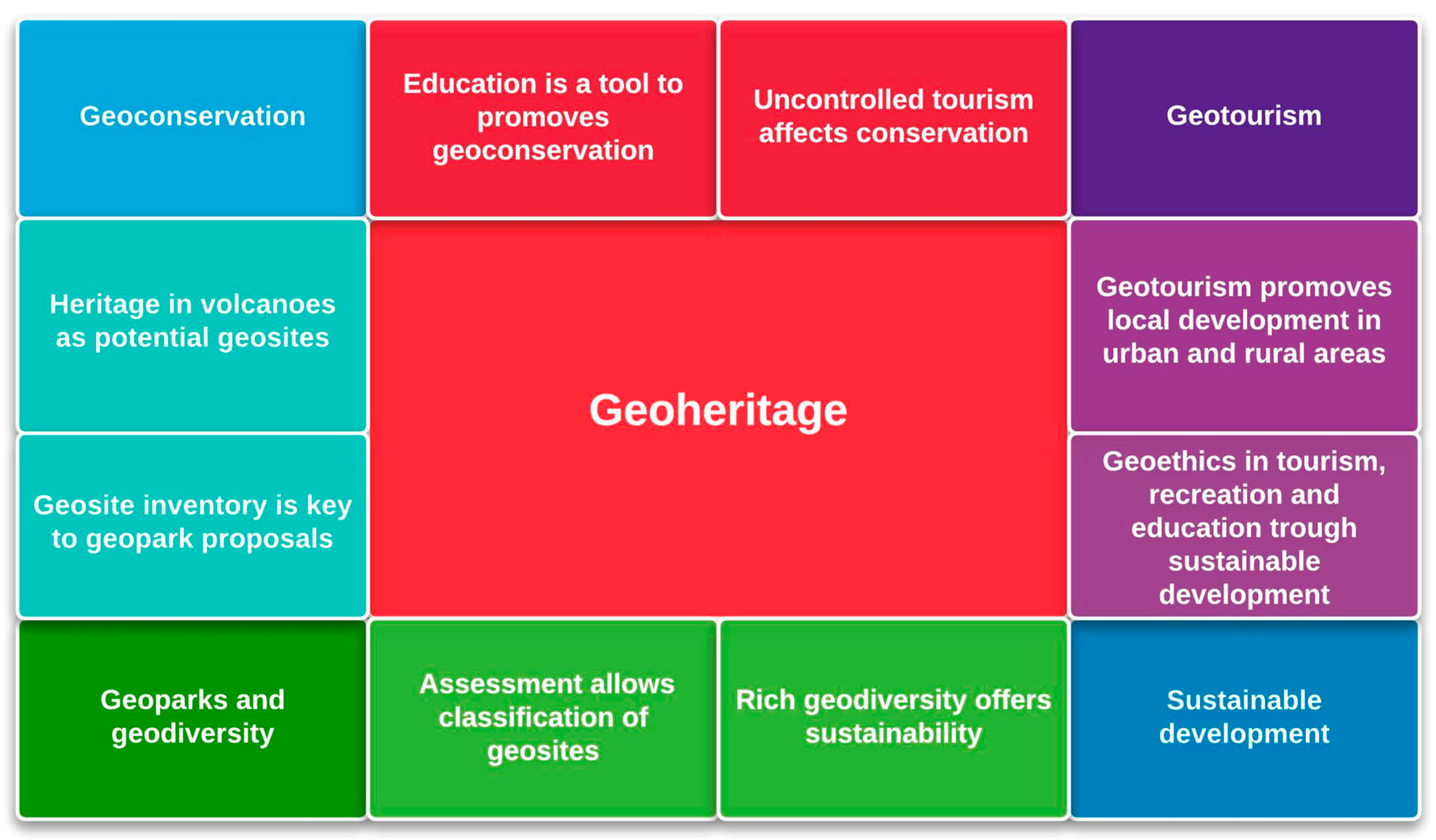
Figure 2.
The multivocality of cultural place names on a trail sign at Sunset (Van Vlack 2025).
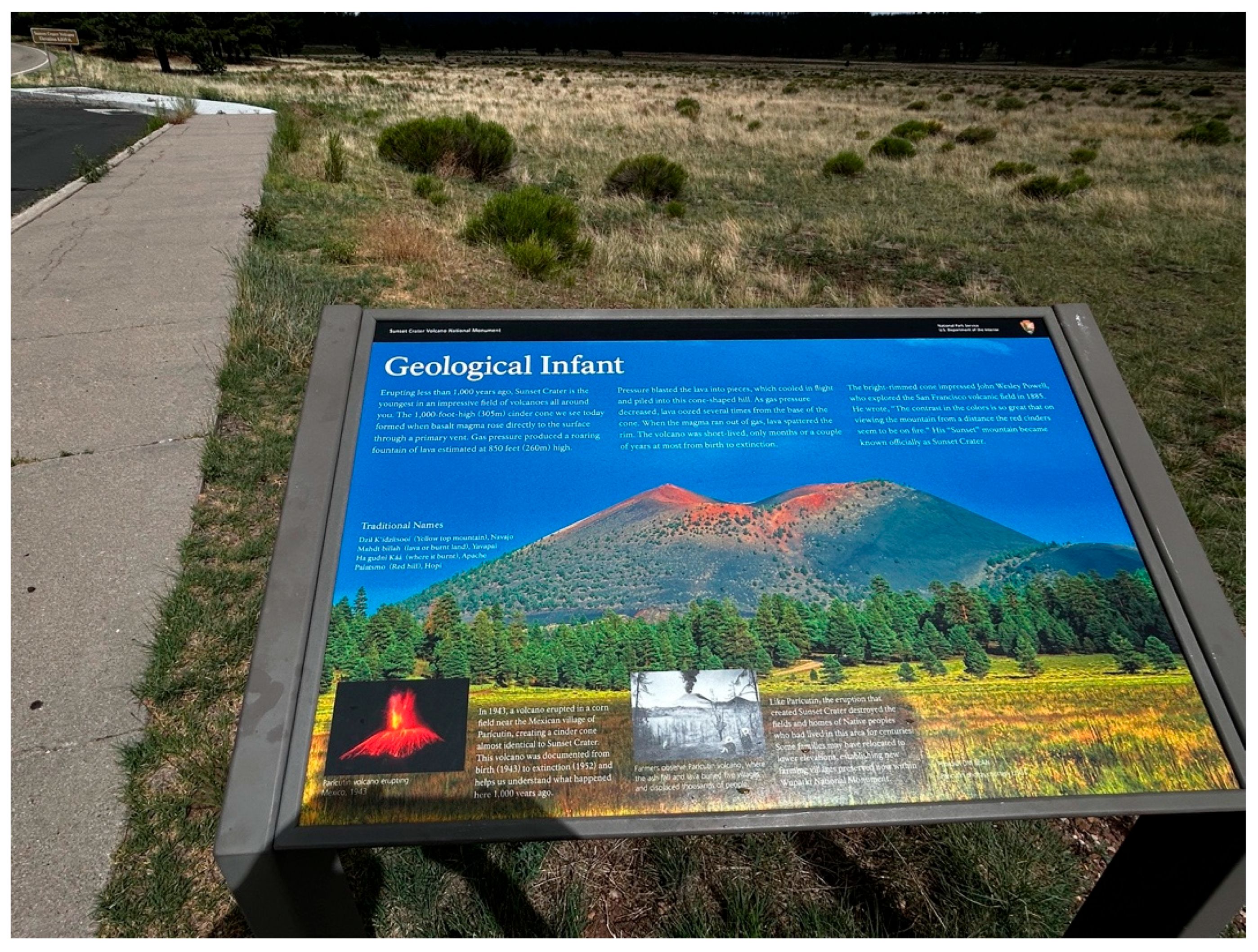
Figure 3.
A Park Trail Sign With Nearby Native Toponyms of Volcanic Mountains.
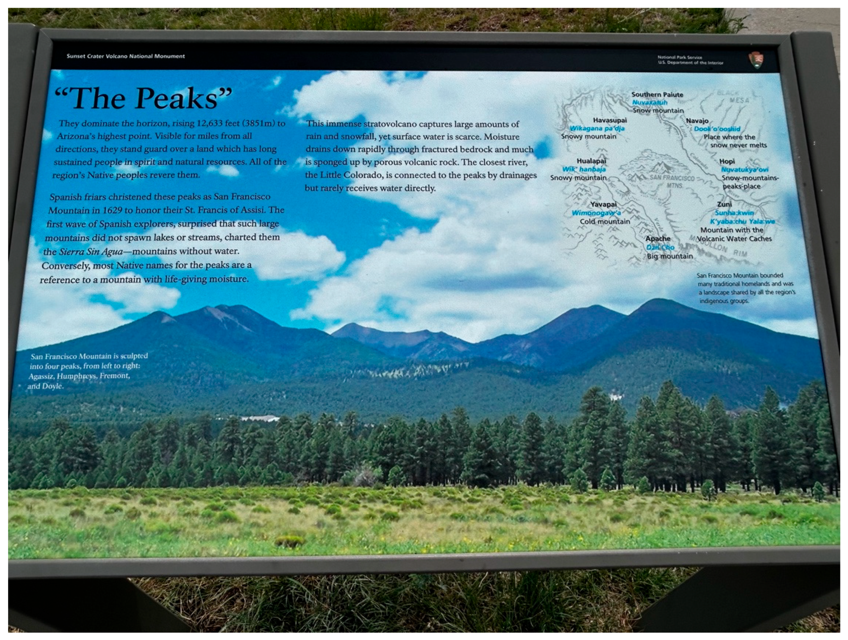
Figure 4.
Postcard by Local Photo Shop, 1930, Using a Native Place Name.

Figure 5.
Mateo Tepe Stairs to Heaven or Devils Tower Steps to Hell?
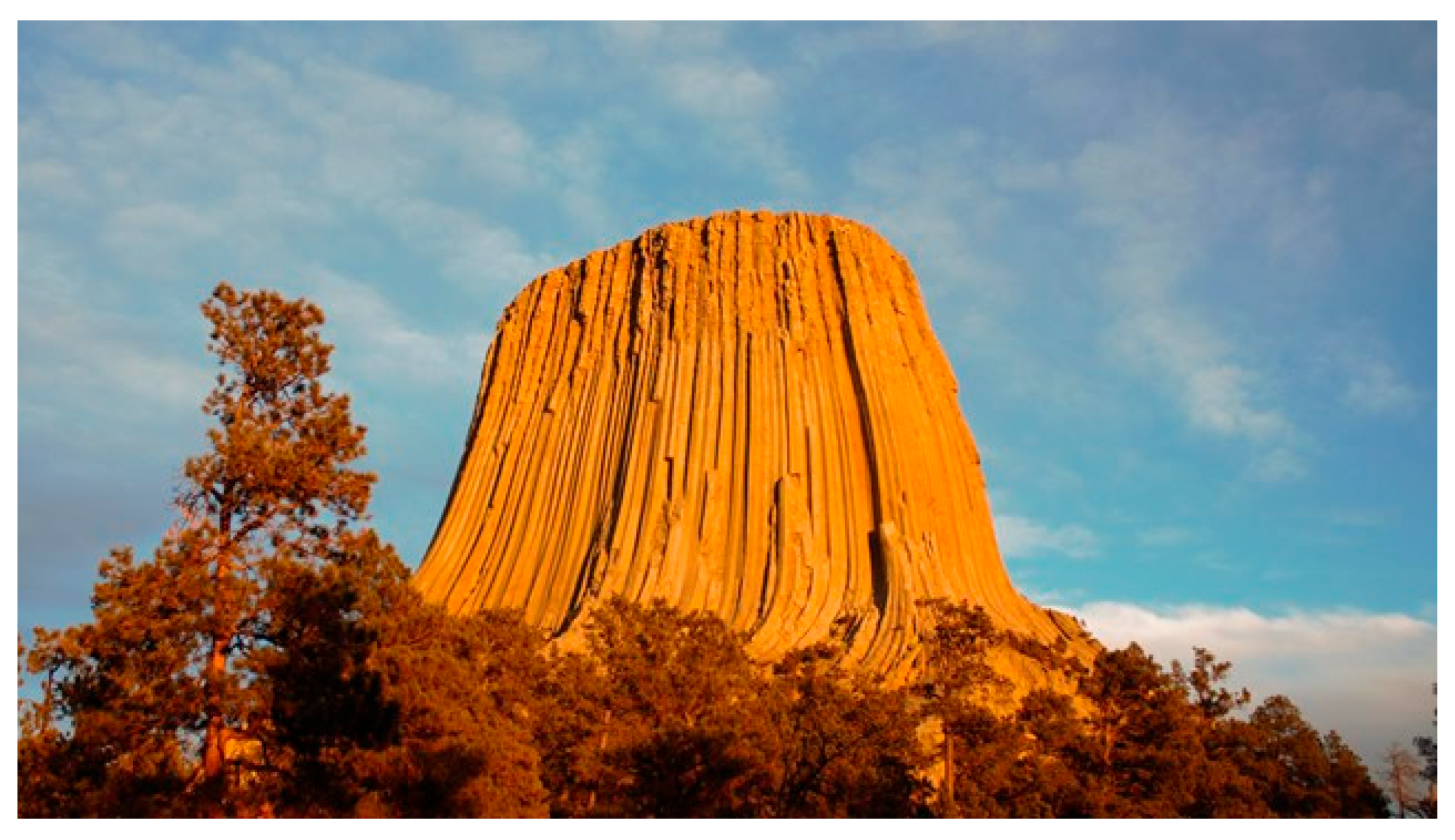
Figure 9.
Ocean Woman atop Old Womans Mountain, California42.
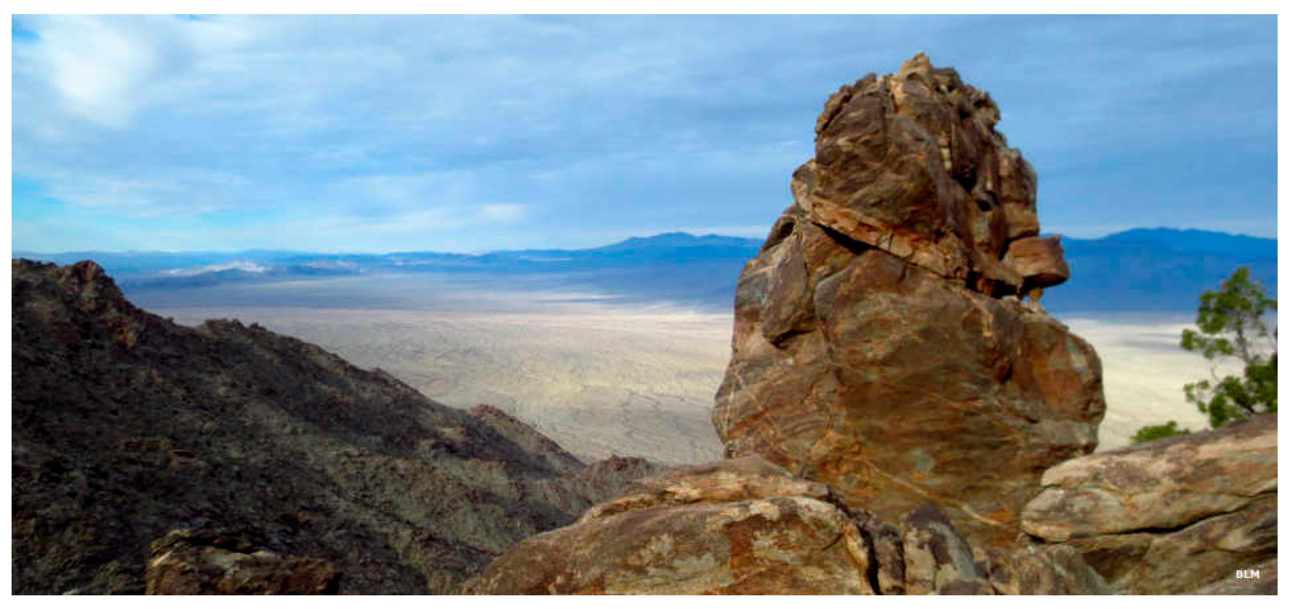
Figure 10.
Two Archaeologists Map a Traditional Trail in the Mojave Desert56.
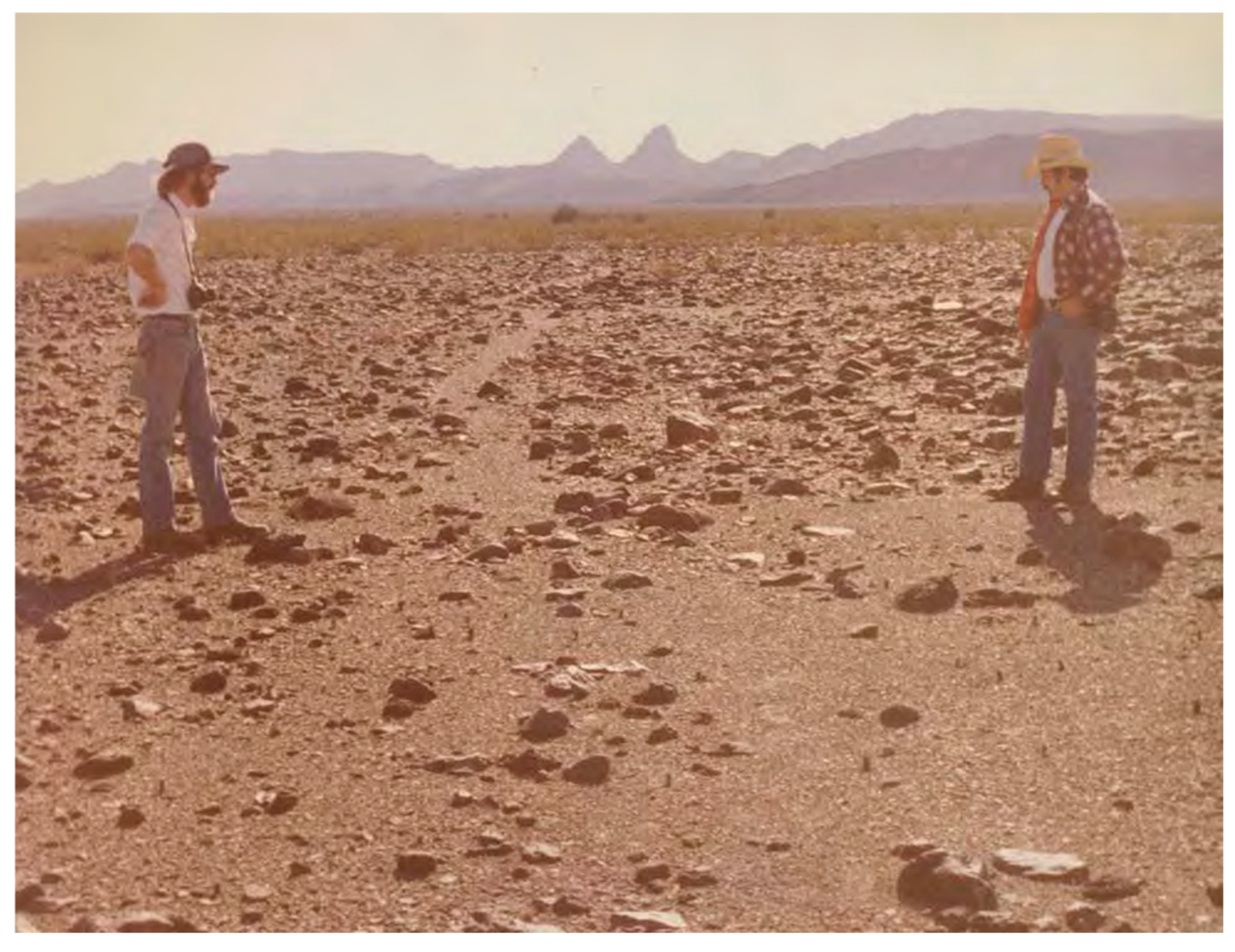
Figure 12.
Bears Ears National Monument in Red and the Bears Ears Geoscape in Black.
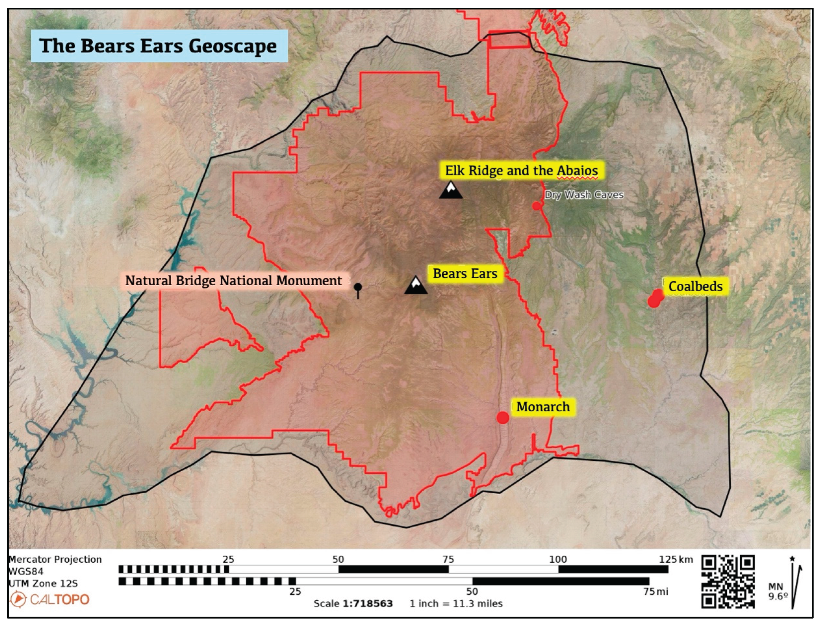
Figure 13.
Erected Stone Pillars.
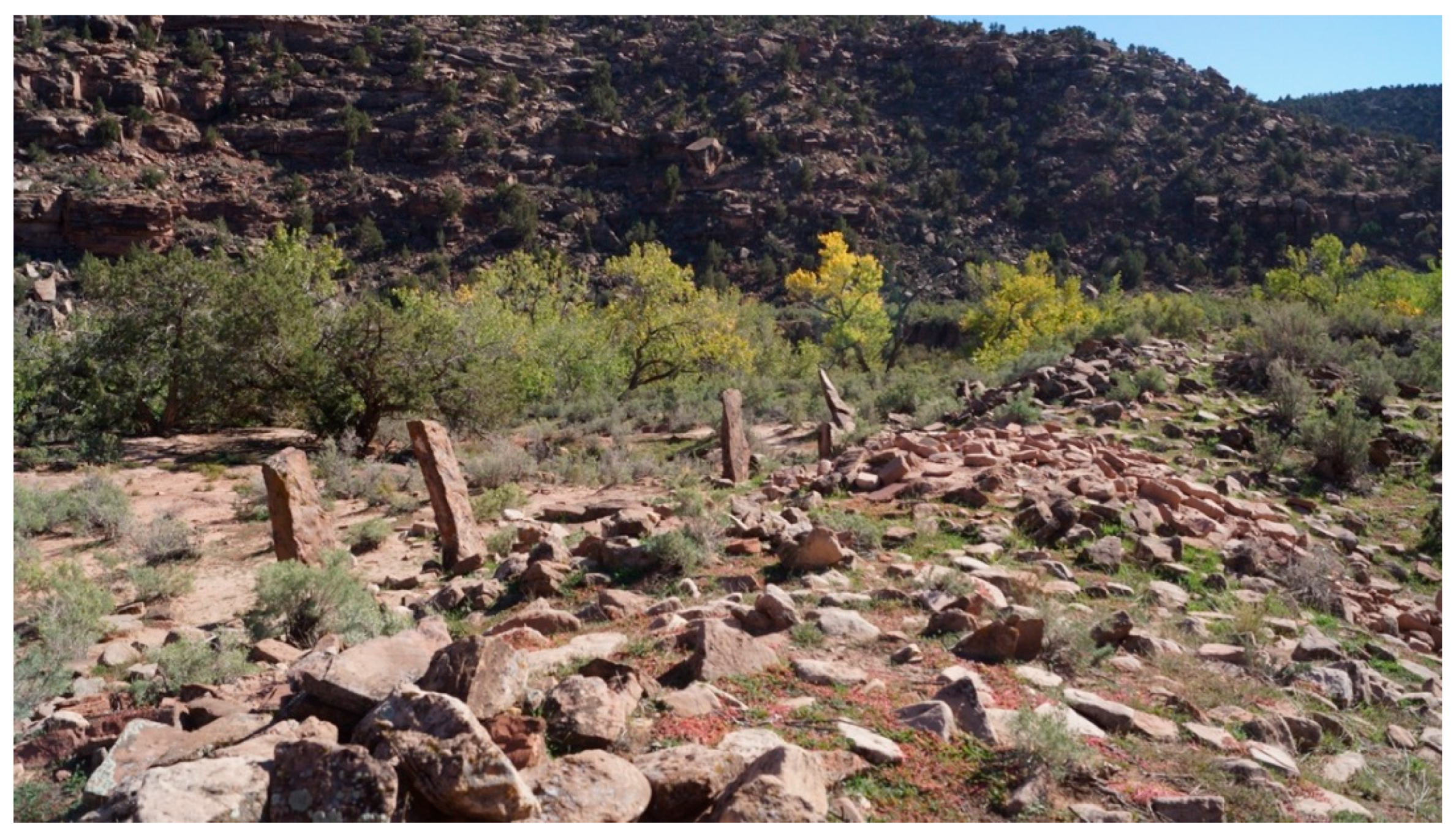
Figure 14.
Remains of a Stone Structure Near the Erected Stone Pillars.
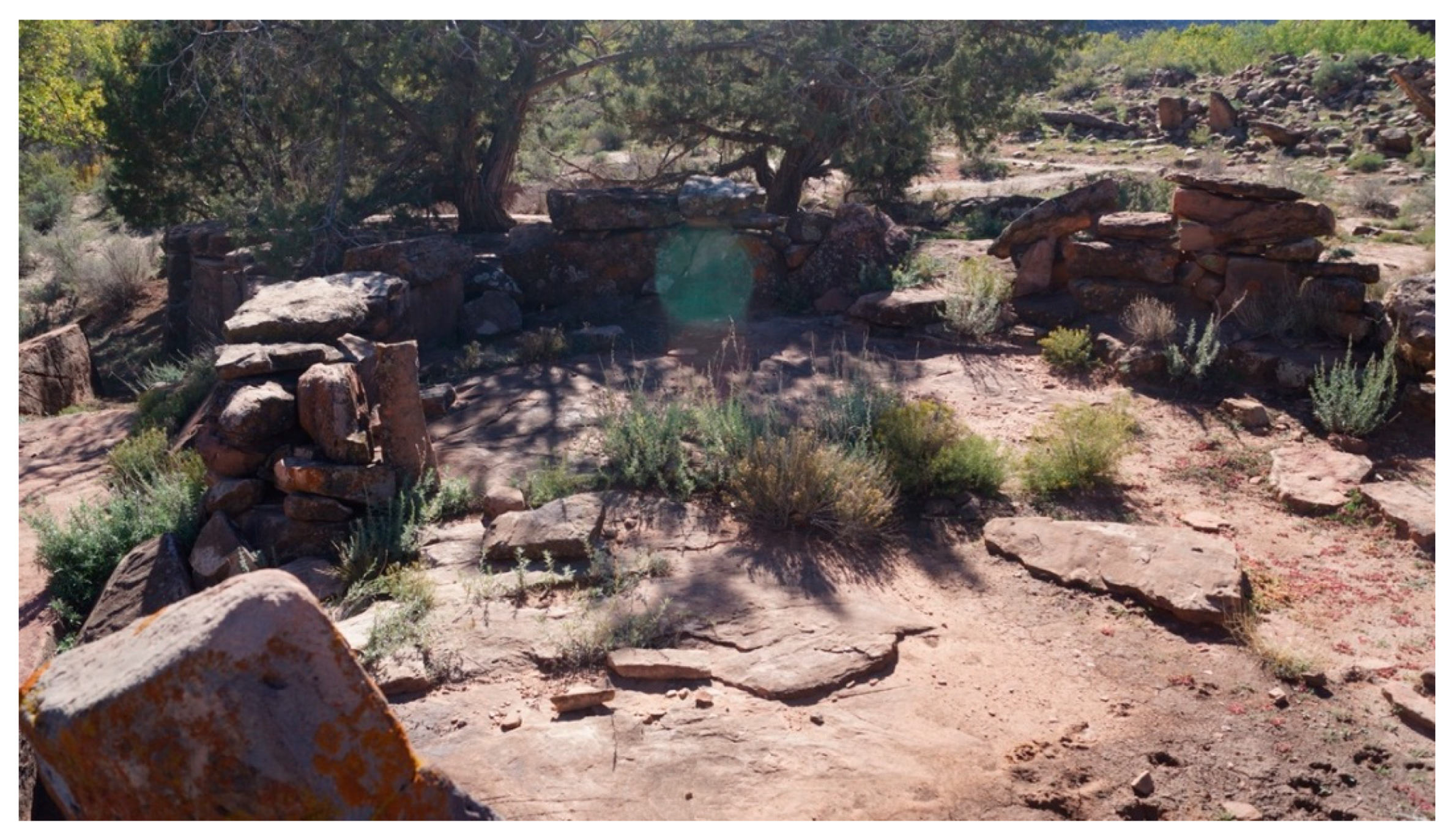
Figure 15.
Pecked Images at Monarch including Transformed Shamans.
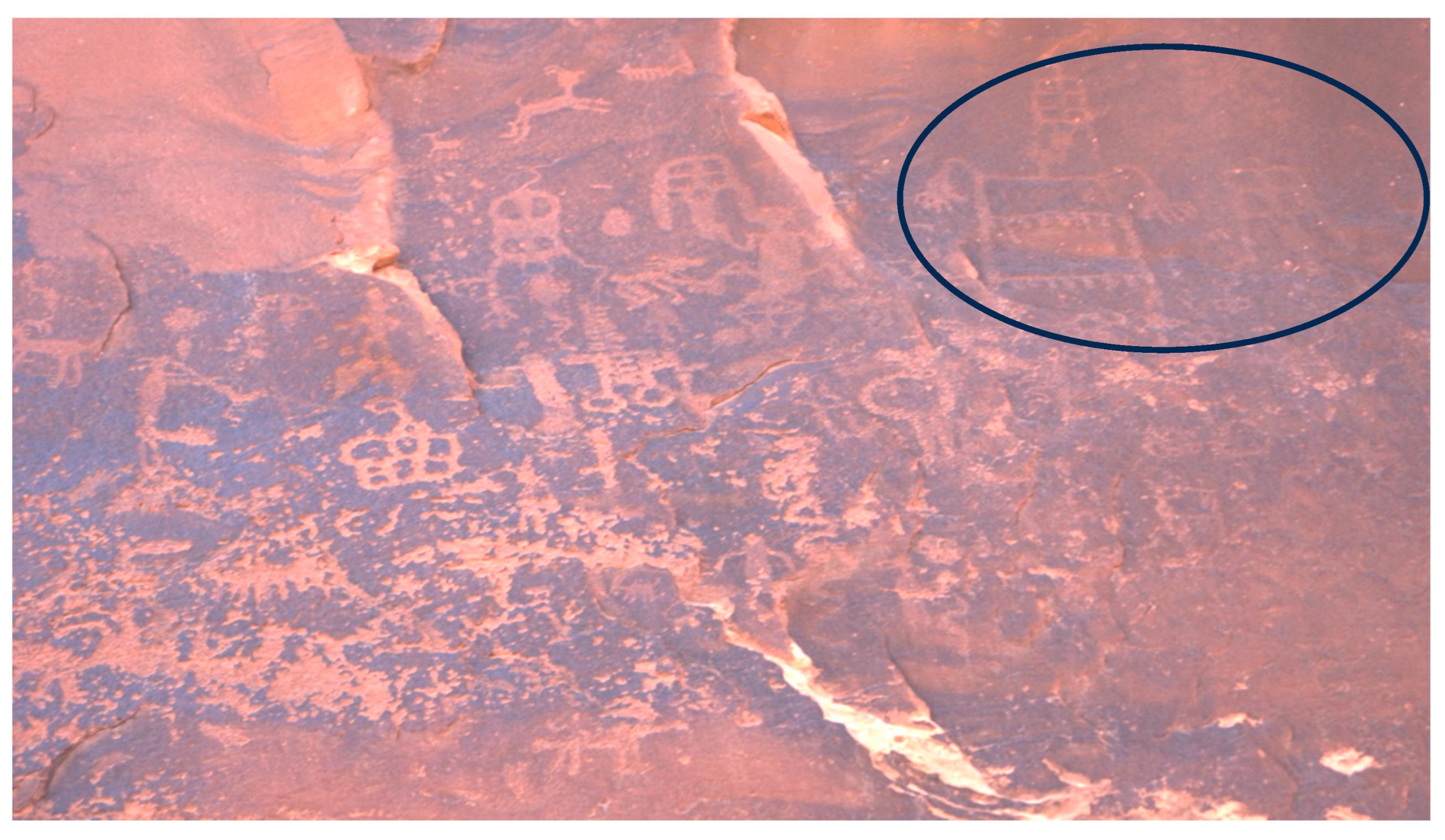
Figure 16.
Large Masonry Structure at Monarch.
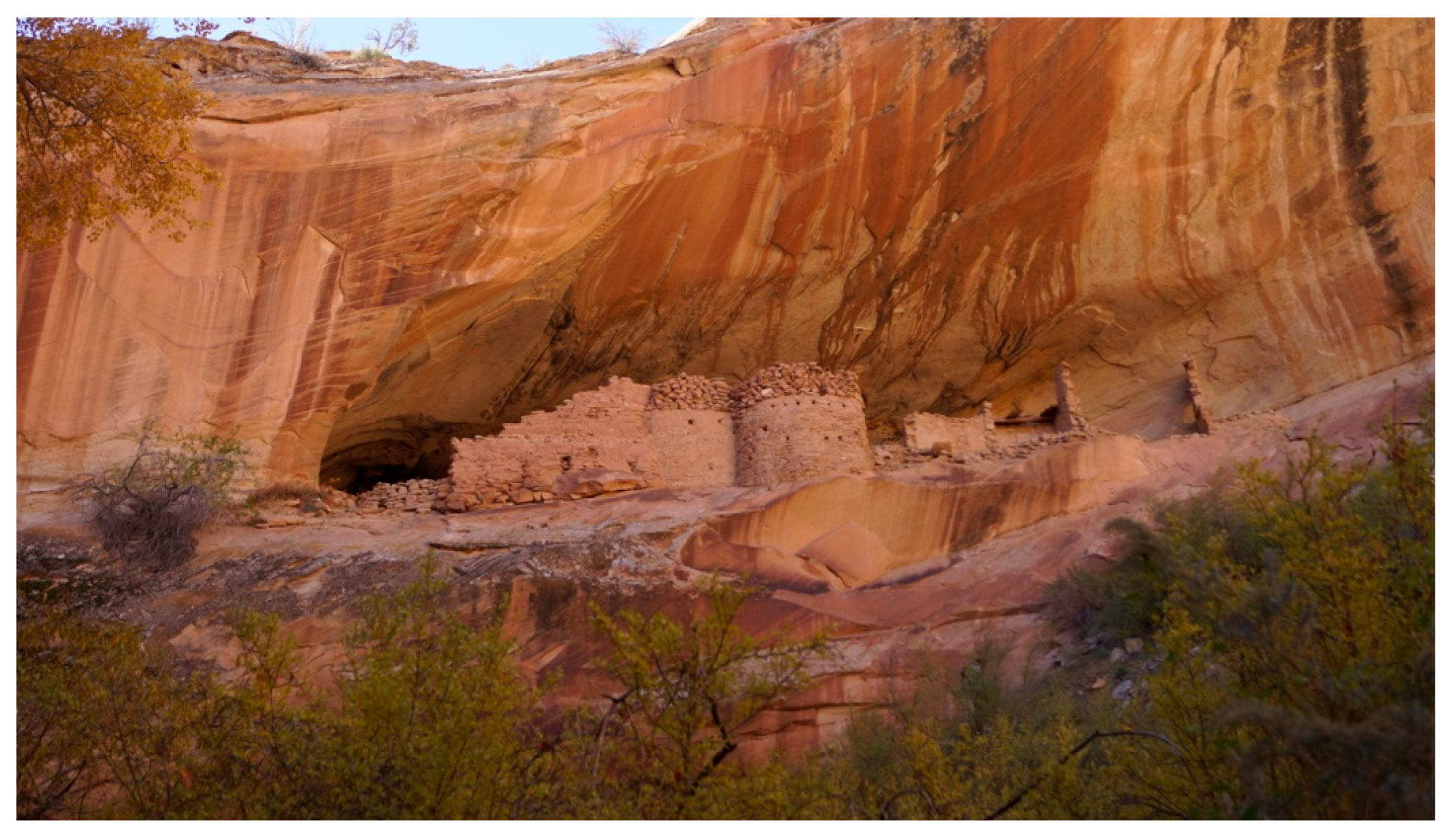
Figure 17.
Iliamna Lake, Biggest Lake in Alaska.
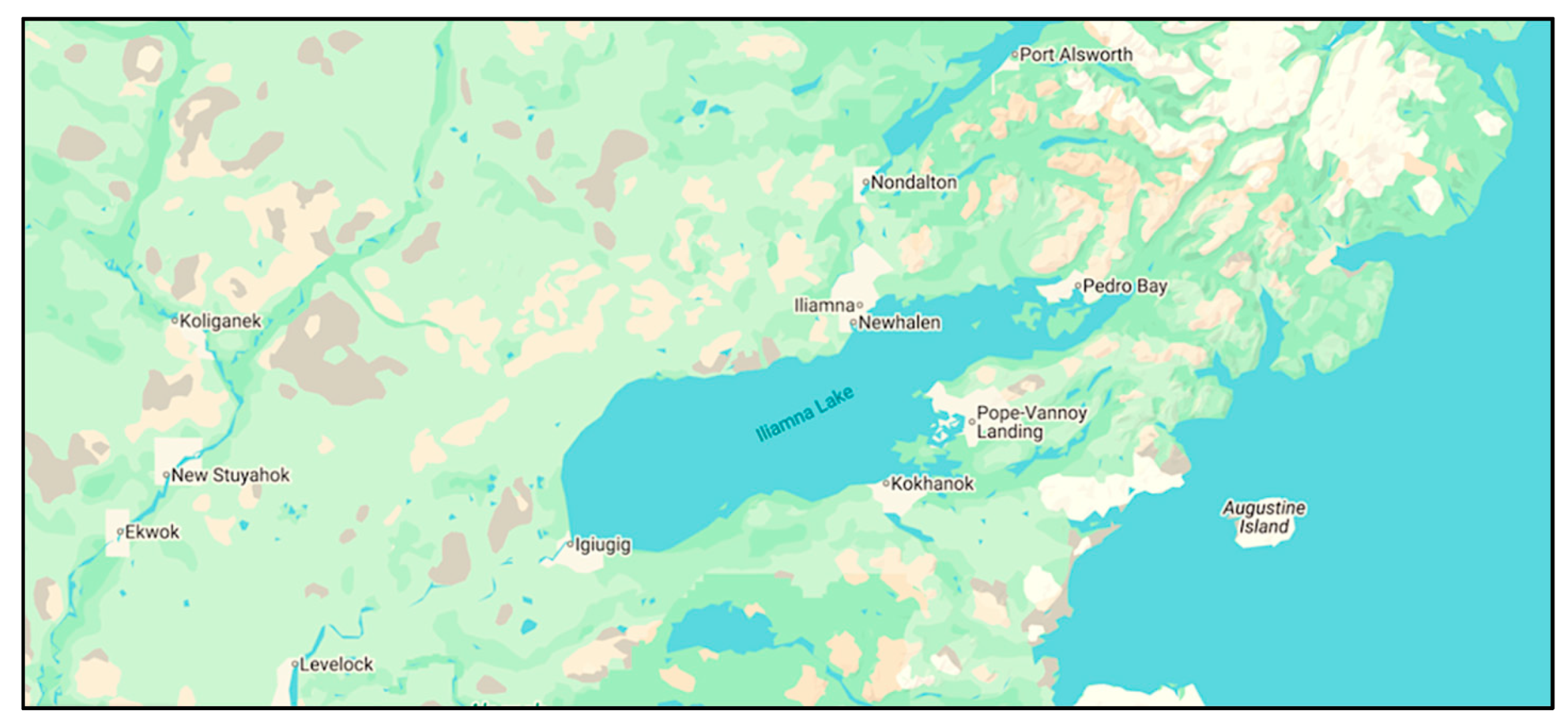
Figure 18.
Volcanic Lava Fields of ELMA.
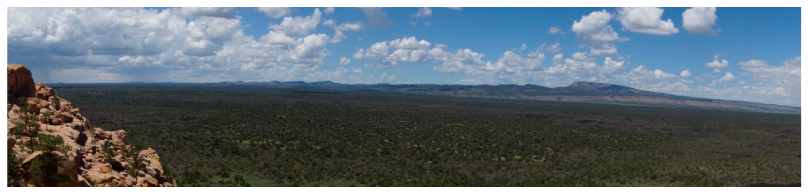
Figure 19.
Mount Taylor.
Figure 20.
Kipukas and Natural Vegetation on one of the Lava Flows.
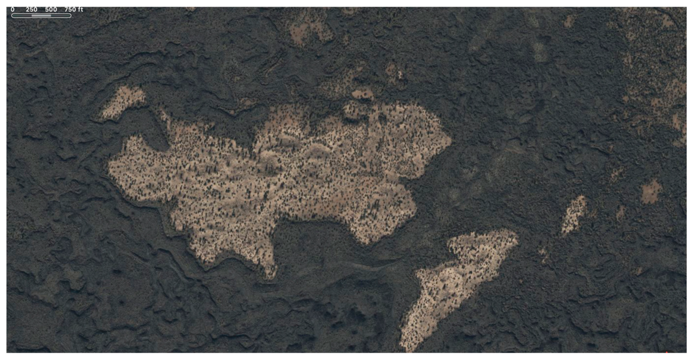
Figure 21.
Archaeology Mapping of Trails and Structure on Kipuka at ELMA.

Figure 22.
One of Many Lava Tunnels in the ELMA.
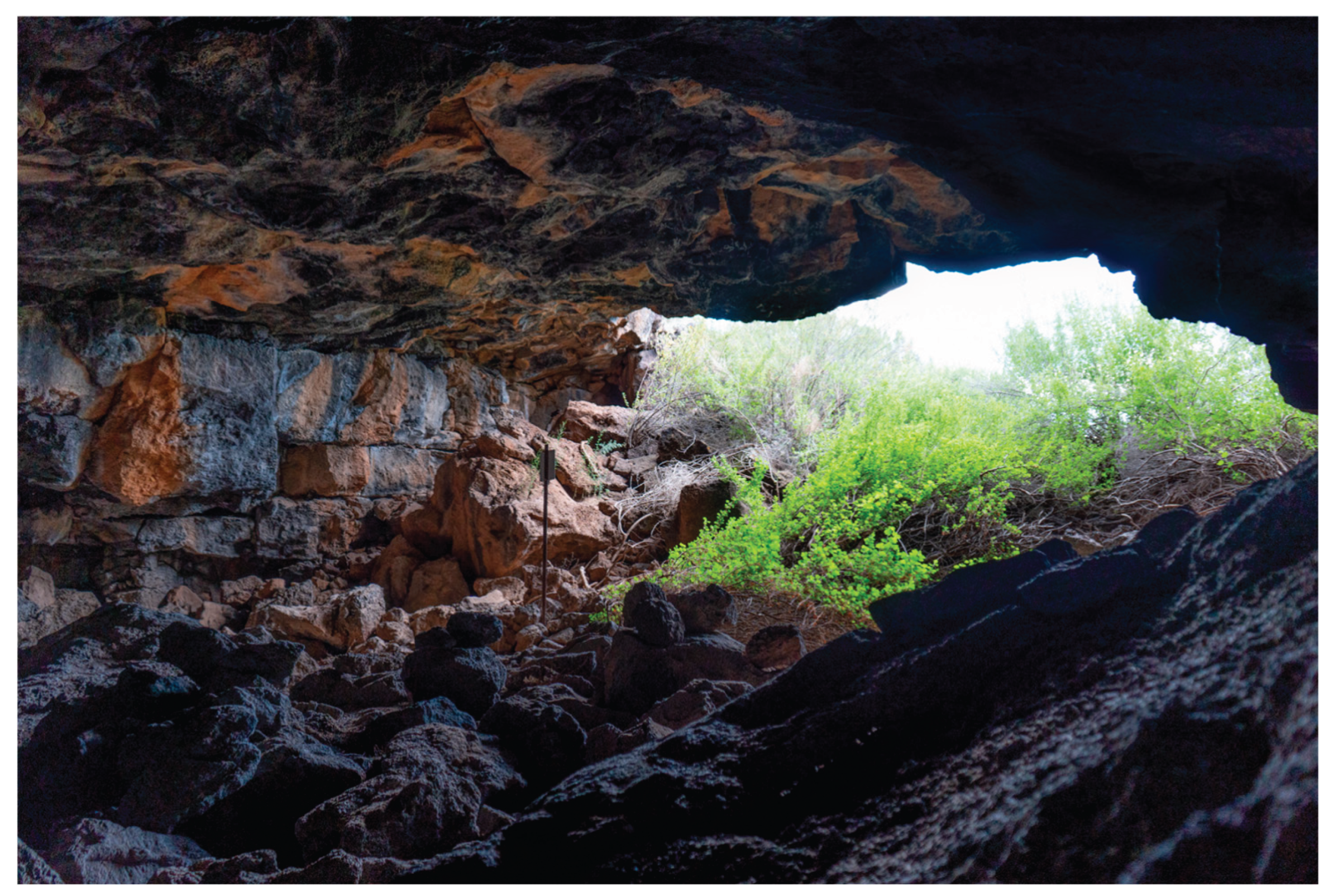
Figure 23.
Elk Bone found at the back of a Cave.
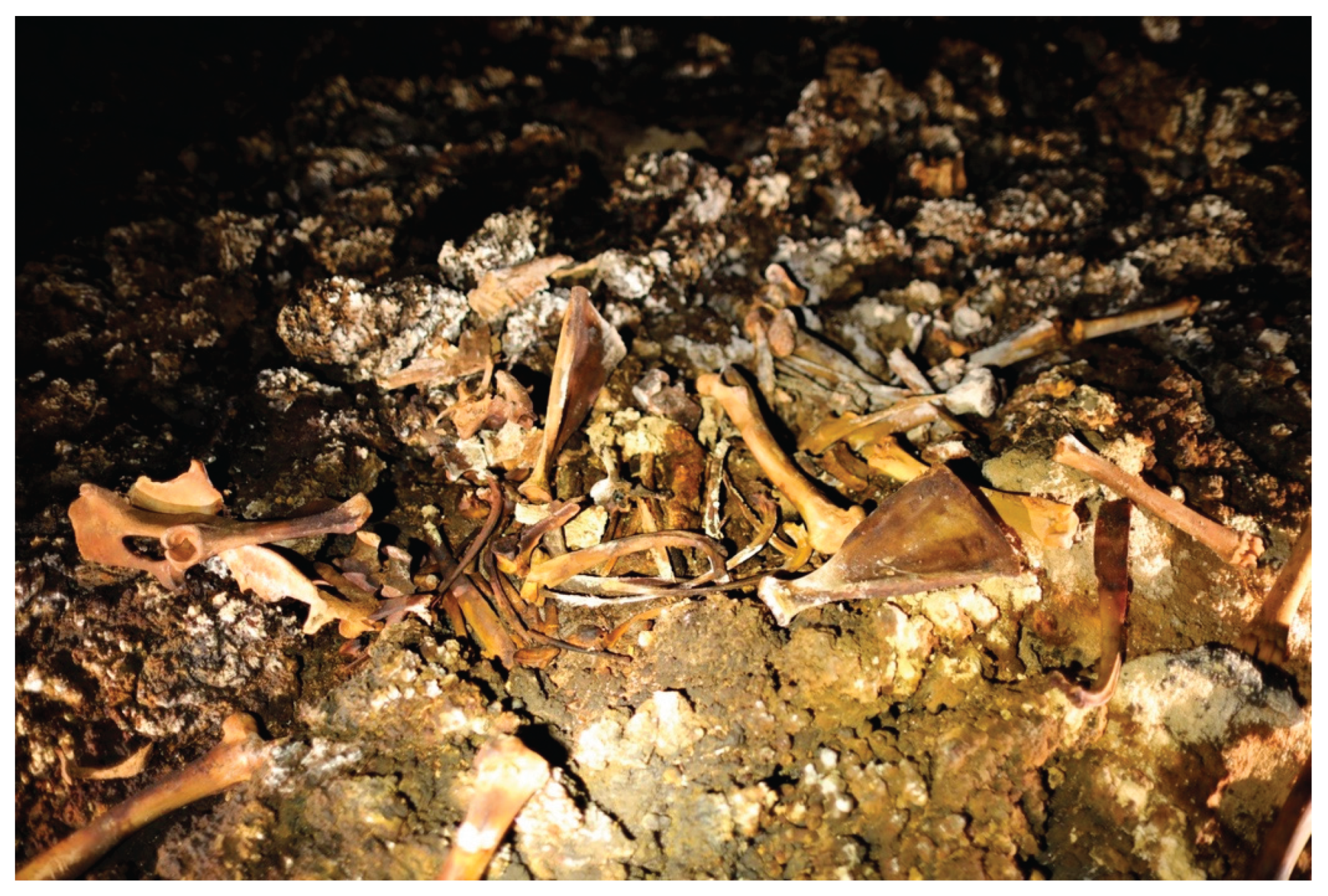
| 1 | The sources of these protocols shared for public education are (1) Larry Eddy the recognized spiritual elder for the Chemehuevi people and a member of the Colorado River Indian Tribes, (2) Mary Lou Brown a plant specialists and Chemehuevi Basketmaker from the Chemehuevi Tribe, (3) Clifford Jake a Southern Paiute spiritual leader from the Indian Peaks Band of the Paiute Tribe of Utah, (4) Yetta Jake a Southern Paiute elder from the Paiute Tribe of Utah, (5) Richard Arnold a spiritual person and Chairperson of the Pahrump Paiute Tribe, (6) Clyde Whiskers a San Juan Southern Paiute Tribe elder, (7) Vivian Jake a Kaibab Band of Paiute Indians elder, and (8) Dan Bulletts a Sothern Paiute spiritual leader from Kaibab and elsewhere. |
Disclaimer/Publisher’s Note: The statements, opinions and data contained in all publications are solely those of the individual author(s) and contributor(s) and not of MDPI and/or the editor(s). MDPI and/or the editor(s) disclaim responsibility for any injury to people or property resulting from any ideas, methods, instructions or products referred to in the content. |
© 2025 by the authors. Licensee MDPI, Basel, Switzerland. This article is an open access article distributed under the terms and conditions of the Creative Commons Attribution (CC BY) license (http://creativecommons.org/licenses/by/4.0/).
Copyright: This open access article is published under a Creative Commons CC BY 4.0 license, which permit the free download, distribution, and reuse, provided that the author and preprint are cited in any reuse.


