1. Introduction
Yemen is currently facing a severe energy crisis characterized by an unreliable grid that serves only 40% of its population and fossil fuel imports that consume 30% of its GDP [
1,
2]. This situation is exacerbated by rapid population growth, conflict-induced infrastructure damage, and climate change vulnerabilities, all of which contribute to deepening energy poverty, hindering economic recovery, and worsening social inequities [
3]. In this context, the transition to renewable energy, particularly solar power, is not just a viable alternative but a critical necessity, given that 80% of households rely on expensive and polluting diesel generators [
4,
5]. Solar energy presents a dual advantage: it reduces dependence on volatile fuel markets and aligns with global climate resilience goals. However, realizing this potential requires a robust site selection framework that balances Yemen’s unique ecological fragility, technical constraints, and post-conflict socioeconomic priorities.
Yemen possesses significant solar resources, with an average Global Horizontal Irradiance (GHI) of 6.5 kWh/m²/day and vast, underutilized desert terrains [
2,
5,
6]. Nevertheless, the process of transforming this potential into equitable and sustainable projects is fraught with challenges. Unlike other nations with abundant solar resources, Yemen’s ongoing conflict, fragmented governance, and limited geospatial data complicate large-scale infrastructure planning. Furthermore, solar development risks exacerbate land-use conflicts in arid ecosystems, displacing pastoral communities, or diverting resources from urgent humanitarian needs [
2,
7]. Therefore, effective site selection must integrate technical feasibility, such as grid proximity and slope gradients, with conflict-sensitive criteria, including avoiding disputed territories and prioritizing energy access for marginalized regions, to ensure projects enhance both energy security and social cohesion.
Globally, multi-criterion decision-making (MCDM) methods, such as the Analytic Hierarchy Process (AHP), have been instrumental in renewable energy planning by systematically weighting environmental, technical, and economic factors [
8,
9,
10]. However, in contexts like Yemen, where expert judgments may be inconsistent or biased because of political instability, traditional MCDM tools struggle with subjective inconsistencies [
11]. The Full Consistency Method (FUCOM), a more recent MCDM approach, addresses these limitations by minimizing biases through fewer pairwise comparisons and ensuring mathematical consistency in criterion weighting, which is particularly advantageous in data-scarce and conflict-affected environments [
12,
13]. Although FUCOM has been successfully applied in industrial logistics and wind energy planning [
14], its integration with Geographic Information Systems (GIS) for solar suitability mapping remains largely unexplored in fragile states, creating a gap in context-specific renewable energy frameworks.
This study aims to bridge this gap by developing a Yemen-specific solar site suitability model that combines the analytical rigor of FUCOM with the spatial precision of GIS. The research is guided by four key objectives: (1) identifying conflict-sensitive criteria for solar deployment, including ecological fragility, land tenure dynamics, and grid resilience; (2) applying FUCOM to derive objective criterion weights, thereby reducing reliance on potentially unstable expert consensus; (3) mapping high-potential zones using GIS spatial analytics; and (4) proposing a policy roadmap for solar projects that emphasizes community co-benefits and disaster resilience.
The study’s methodological innovation lies in its integration of FUCOM’s reliability with GIS’s detailed spatial analysis, offering a replicable model for energy transitions in conflict-affected regions. For policymakers, the findings provide a conflict-sensitive blueprint for avoiding ecologically sensitive areas and directing investments toward regions with high energy poverty reduction potential. For researchers, this work demonstrates how advanced MCDM tools can be adapted to overcome data limitations in fragile states, ensuring that renewable energy planning is both technically sound and socially equitable.
2. Methodology
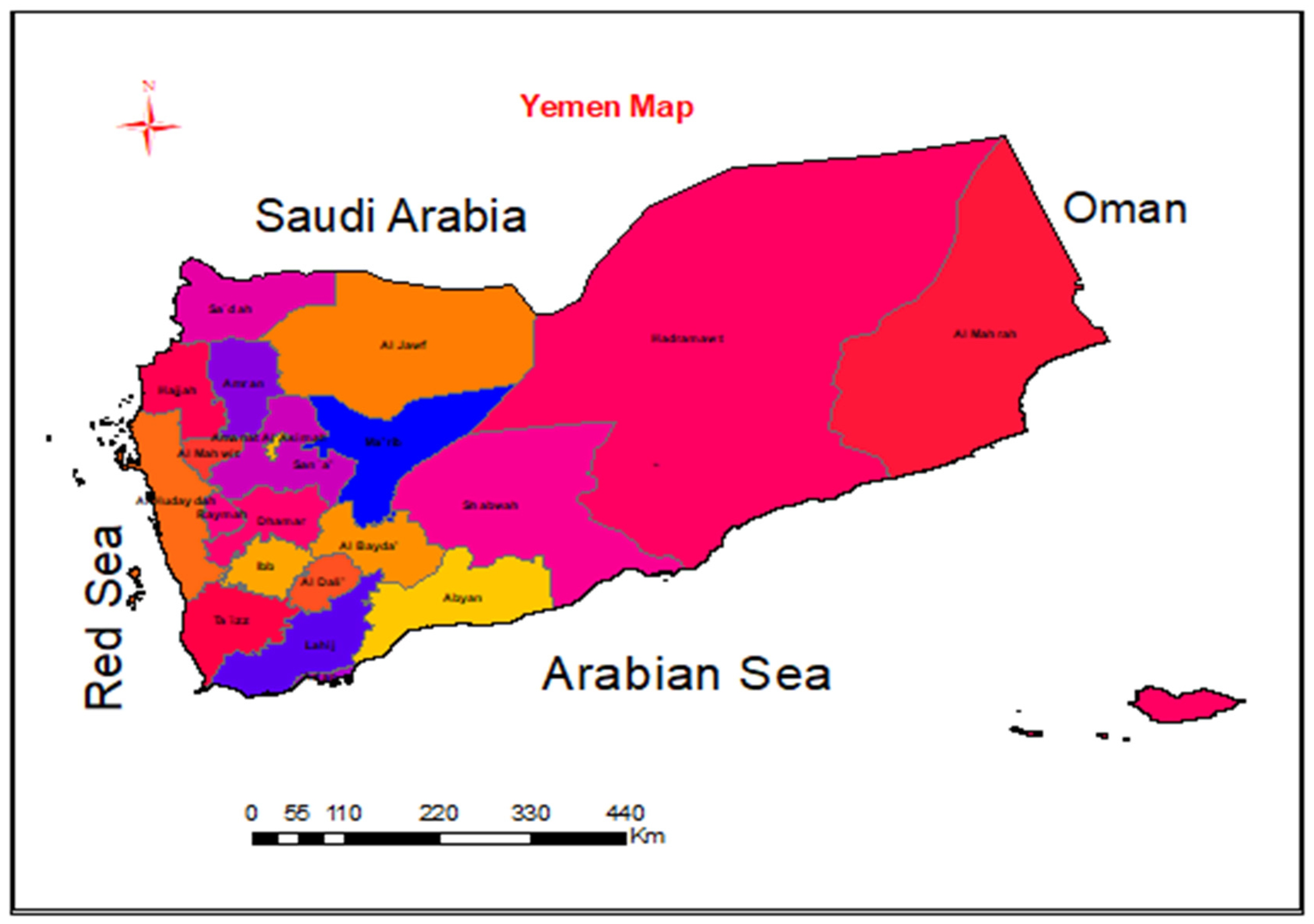
2.1. Study Area
Yemen, situated at the southern tip of the Arabian Peninsula (12°′19°N, 42°′54°E), encompasses a diverse geographical landscape across its approximately 555,000 km² [
15,
16]. This diversity is crucial for evaluating solar energy potential because the country is divided into three distinct zones. The coastal plains, bordering the Red Sea and Gulf of Aden, are characterized by arid lowlands and high temperatures. However, urban expansion and agricultural activities limit their suitability for large-scale solar deployment. Second, the Western Highlands, which include the Sarawat Mountains, receive moderate orographic rainfall but present significant terrain constraints for extensive solar infrastructure. Finally, the Eastern Desert, within the Rub’ al Khali basin, stands out as a hyper-arid region with minimal precipitation, sparse population, and vast, flat areas, making it exceptionally favorable for solar farms [
17,
18].
Yemen’s climate, classified as hot arid (BWh) under the Köppen-Geiger system, experiences significant temperature variations, with average temperatures ranging from 25°C in the highlands to 35°C in the deserts [
19,
20]. The country benefits from substantial solar irradiance, ranging from 6.0 to 8.0 kWh/m²/day, with the highest values concentrated on the Eastern Desert. Despite this potential, the region faces challenges such as dust storms and extreme aridity, which can affect solar panel efficiency [
21,
22]. This study adopts a comprehensive approach, evaluating solar energy potential across all of Yemen to account for regional variations in solar resources, terrain constraints, land-use conflicts, and proximity to existing transmission corridors. This holistic evaluation aligns with global best practices for solar energy deployment in arid and semi-arid regions [
23,
24], ensuring an optimal balance between energy yield and long-term sustainability in a nation grappling with energy poverty and environmental vulnerabilities.
2.2. Site Selection Criteria and Expert Consultation
To accurately identify optimal locations for solar farm development in Yemen, a comprehensive methodology was implemented. This methodology integrated a thorough review of relevant literature, expert consultation, and the application of the Full Consistency Method (FUCOM). The literature review encompassed academic studies, industry reports, and government documents, focusing on solar site selection methodologies and the deployment of renewable energy in arid regions. Subsequently, a panel of 12 experts, each possessing specialized knowledge in solar engineering, environmental science, and energy policy, was assembled. These experts, identified through professional networks and institutional affiliations, contributed critical insights through structured interviews and questionnaires. The study assessed the relative importance of potential site selection criteria within the specific environmental and socioeconomic context of Yemen. This integrated approach, combining theoretical knowledge with practical expertise, facilitated the development of a set of weighted criteria, which were then quantitatively assessed using the FUCOM method to determine the relative importance of each factor.
2.3. Geospatial Data Acquisition and Standardization
The identification of suitable solar energy project sites in Yemen was based on a multi-criteria decision analysis that considered 12 factors, categorized into four primary areas: (1) solar and climatic conditions, (2) topographical characteristics, (3) land use and environmental constraints, and (4) infrastructure and accessibility. To ensure accurate and comprehensive spatial coverage, geospatial datasets were acquired from global repositories, satellite imagery, and remote sensing platforms. Solar potential was evaluated using Global Horizontal Irradiance (GHI) data at 1 km² resolution from the World Bank’s Global Solar Atlas (2023) [
25,
26], which was validated against ground measurements from the National Renewable Energy Laboratory (NREL, 2022) [
27,
28], and annual mean temperature datasets to account for thermal efficiency impacts [
29]. The topographical analysis utilized a 30-m digital elevation model (DEM) from NASA’s ASTER GDEM V3 [
30,
31], from which slope (less than 15 degrees) and aspect layers were derived to assess terrain suitability. Land use constraints were mapped using ESA WorldCover 2022 (10-meter resolution) datasets to exclude protected areas, forests, and agricultural zones [
32,
33], while UNEP-WCMC (2023) datasets defined environmental buffers around ecologically sensitive regions such as coastlines, rivers, and archeological sites [
34]. Infrastructure proximity was analyzed using OpenStreetMap (2023) vector data, which included roads, power grids, and settlements [
35,
36]. All datasets were standardized to a uniform 38-m cell size with a resolution selected to balance the computational efficiency with the level of detail required for site selection. The datasets were projected in WGS84/UTM Zone 38N using ArcGIS 10.8. Min-max normalization (0–9 scale) was applied to rescale criteria values, such as irradiance, slope, and temperature, to a standardized range, facilitating consistent multi-criteria overlay analysis [
37,
38].
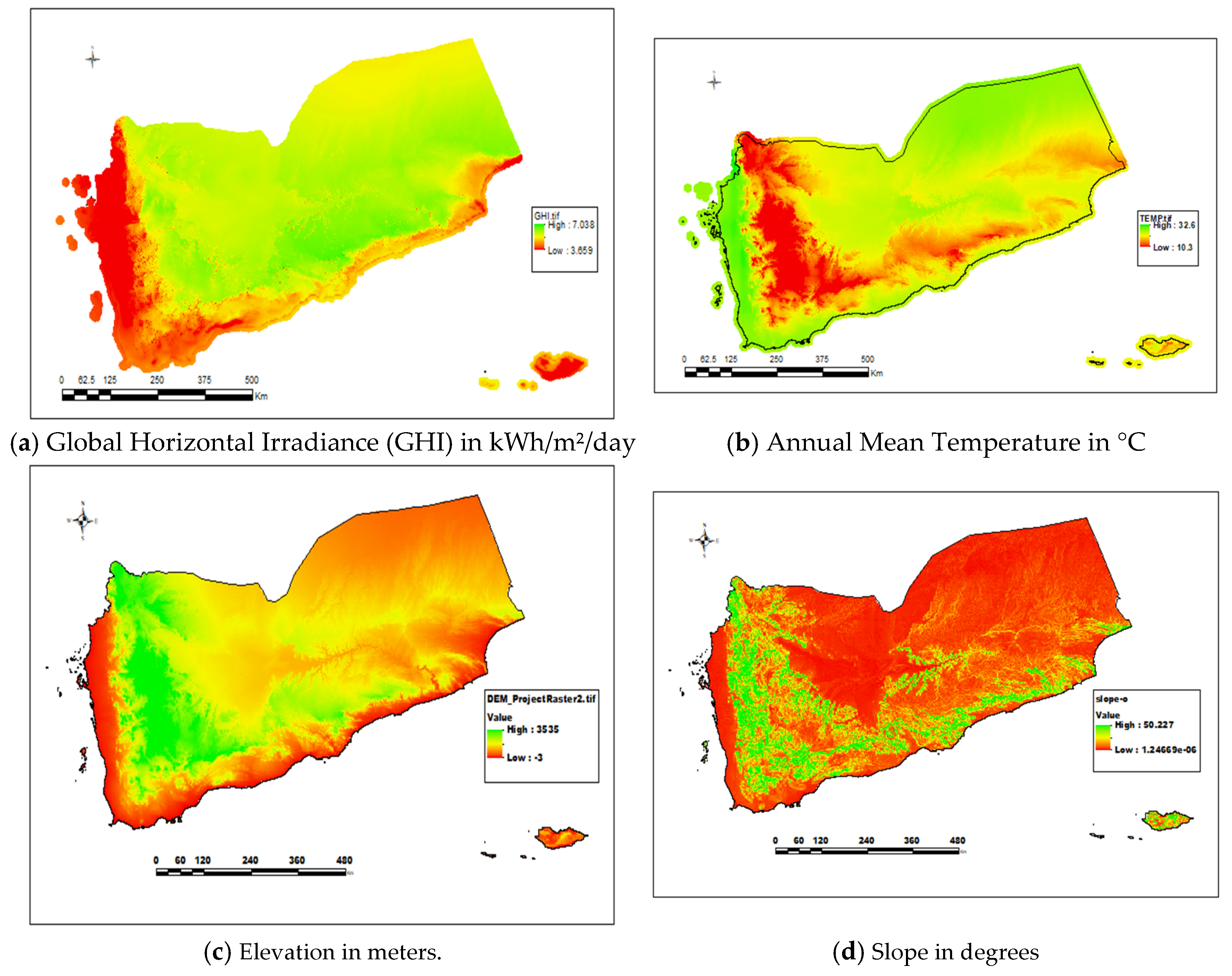
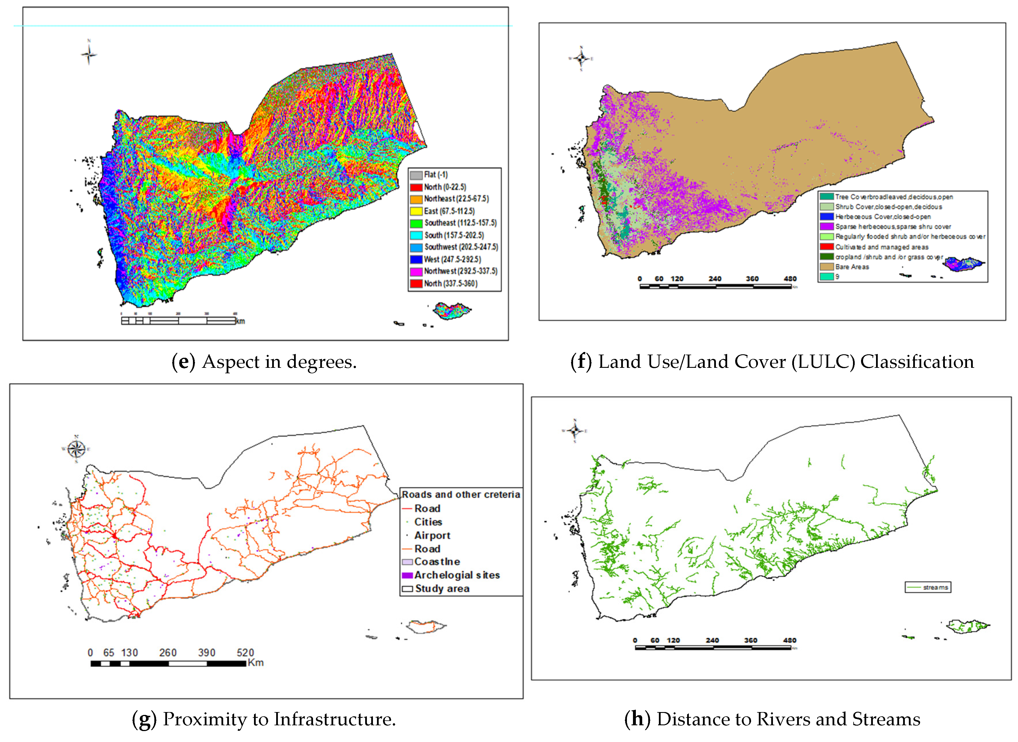
Figure 2 illustrates the eight key criteria layers: (a) GHI, (b) annual mean temperature, (c) elevation, (d) slope, (e) aspect, (f) land use/cover, (g) infrastructure proximity, and (h) distance to rivers and streams. GHI (Figure 2A) and annual mean temperature (Figure 2B) were used to assess solar and climatic factors. The elevation, slope, and aspect, derived from the DEM, were used for the topographical analysis (Figure 2C-E). Land use/Land cover (Figure 2F) and environmental buffers (Figure 2G-H) represent land use and environmental considerations.
Figure 2.
Data Sources and Criteria Layers.
Figure 2.
Data Sources and Criteria Layers.
2.4. Determining Criteria’s Importance Using the Full Consistency Method (FUCOM)
To establish the relative importance of the 12 criteria used in solar site selection, the Full Consistency Method (FUCOM) was employed [
39,
40]. FUCOM, a robust multi-criteria decision-making (MCDM) technique, was selected for its capacity to minimize subjective bias and ensure consistency in criteria comparisons, offering notable advantages over methods such as the Analytical Hierarchy Process (AHP) [
13]. This was particularly crucial for the GIS-based decision-making process, which required the integration of diverse spatial factors. To effectively implement FUCOM, a panel of 12 experts was selected. These experts held advanced degrees in renewable energy, GIS, or related fields, and each possessed a minimum of five years of practical experience in solar energy projects in arid environments analogous to Yemen. Their expertise encompassed solar engineering, GIS analysis, environmental science, and energy policy. Each expert was tasked with independently ranking the 12 criteria from most to least important, thereby generating an ordered list in which C1 represented the highest priority and C12 represented the lowest. In instances where experts deemed two or more criteria equally important, they were instructed to indicate this accordingly. To ensure the accuracy and practical relevance of the rankings, a Delphi-style approach was implemented [
34,
41,
42]. This involved conducting multiple rounds of discussions and feedback sessions until a consensus of at least 80% was achieved among experts regarding the final ranking of each criterion. This consensus-driven methodology effectively mitigated individual biases and significantly enhanced the reliability of the resulting rankings [
43]. The final agreed-upon rankings of the criteria along with their mean importance scores, which represent the average relative importance assigned by the experts, are presented in Table 1.
Table 1.
Criteria Ranking and Mean Scores.
Table 1.
Criteria Ranking and Mean Scores.
| Rank |
Criteria |
Mean Scores (Cj) |
| 1 |
global horizontal irradiance |
9 |
| 2 |
elevation |
5.59 |
| 3 |
distance to the main roads |
3.51 |
| 4 |
temperature |
2.3 |
| 5 |
distance to the cities |
2.03 |
| 6 |
aspect |
2.03 |
| 7 |
Land use land cover |
2 |
| 8 |
Slope |
2 |
| 9 |
distance to the coastline |
1.75 |
| 10 |
Distance to the rivers and streams |
1.74 |
| 11 |
Distance to the airports |
1.17 |
| 12 |
Distance to the archeological sites |
1 |
2.4.1. Calculating Criteria Weights Using FUCOM
To precisely quantify the importance of each criterion, the FUCOM method was applied [
44]. This process involves calculating the comparative priority ratios between consecutively ranked criteria. For each pair of ranked criteria, the ratio was determined by dividing the respective mean importance scores, which were derived from the expert consensus. For example, the ratio between Global Horizontal Irradiance (rank 1) and Elevation (rank 2) was calculated by dividing the mean importance score of GHI by that of Elevation. These priority ratios were then used to develop a system of linear equations. This system was solved using a linear programming technique implemented in MATLAB [
45], which ensured that the resulting criterion weights accurately reflected their relative importance. To validate the consistency of the expert judgments, a consistency ratio (CR) was calculated. A CR below 0.1 indicates a high level of consistency. In this study, the calculated CR was 0.048, indicating a strong degree of consistency among the expert evaluations.
2.4.2. Generating a Solar Site Suitability Map with GIS
After determining the criterion weights, a solar site suitability map was generated using ArcGIS 10.8 [
46,
47,48]. This process involves integrating the FUCOM-derived weights with the corresponding standardized geospatial data. To ensure that each criterion contributed proportionally to the overall suitability score, the FUCOM weights were applied as multipliers in a weighted overlay analysis. Before this overlay, the standardized geospatial data, which were in the 0-1 range from the min-max normalization, were further transformed using a custom linear scaling method. This method rescales the data to a distinct range of 1–9, aligning with a common scoring system used in expert evaluations and facilitating a more intuitive interpretation of suitability levels. The weighted overlay analysis, a standard GIS technique for multi-criteria evaluation [
34], combined these rescaled and weighted data layers to produce the final suitability map, visually representing the optimal locations for solar energy development.
3. Results
3.1. Determining Criteria’s Importance and Ensuring Consistency
To identify optimal locations for solar energy development in Yemen, this study utilized the Full Consistency Method (FUCOM) [
35], combined with Geographic Information System (GIS) techniques [
36], to conduct a comprehensive solar site suitability analysis. This approach effectively addresses Yemen’s pressing need for sustainable energy solutions. We evaluated 12 critical criteria that influence solar site suitability using the FUCOM method. The resulting weightings in Table 1 reveal the relative importance of each factor. As expected, Global Horizontal Irradiance (GHI) emerged as the most significant criterion, with a weight of 0.2638, underscoring the fundamental importance of solar resource availability. Elevation (0.1638) and proximity to main roads (0.1029) also played significant roles, reflecting the practical considerations of terrain and accessibility for solar farm development. The reliability of the FUCOM method was confirmed by a low consistency ratio (CR) of 0.048, which was well below the acceptable threshold of 0.10, indicating a high level of consistency in expert judgments.
Table 1.
FUCUM-derived criteria weight.
Table 1.
FUCUM-derived criteria weight.
| Criteria |
Weight
|
| global horizontal irradiance |
0.2638
|
| elevation |
0.1638
|
| distance to the main roads |
0.1029
|
| temperature |
0.0674
|
| distance to the cities |
0.0595
|
| aspect |
0.0595
|
| Land use land cover |
0.0586
|
| Slope |
0.0586
|
| distance to the coastline |
0.0513
|
| Distance to the rivers and streams |
0.0510
|
| Distance to the airports |
0.0343
|
| Distance to the archeological sites |
0.0293
|
3.2. Mapping Solar Site Suitability
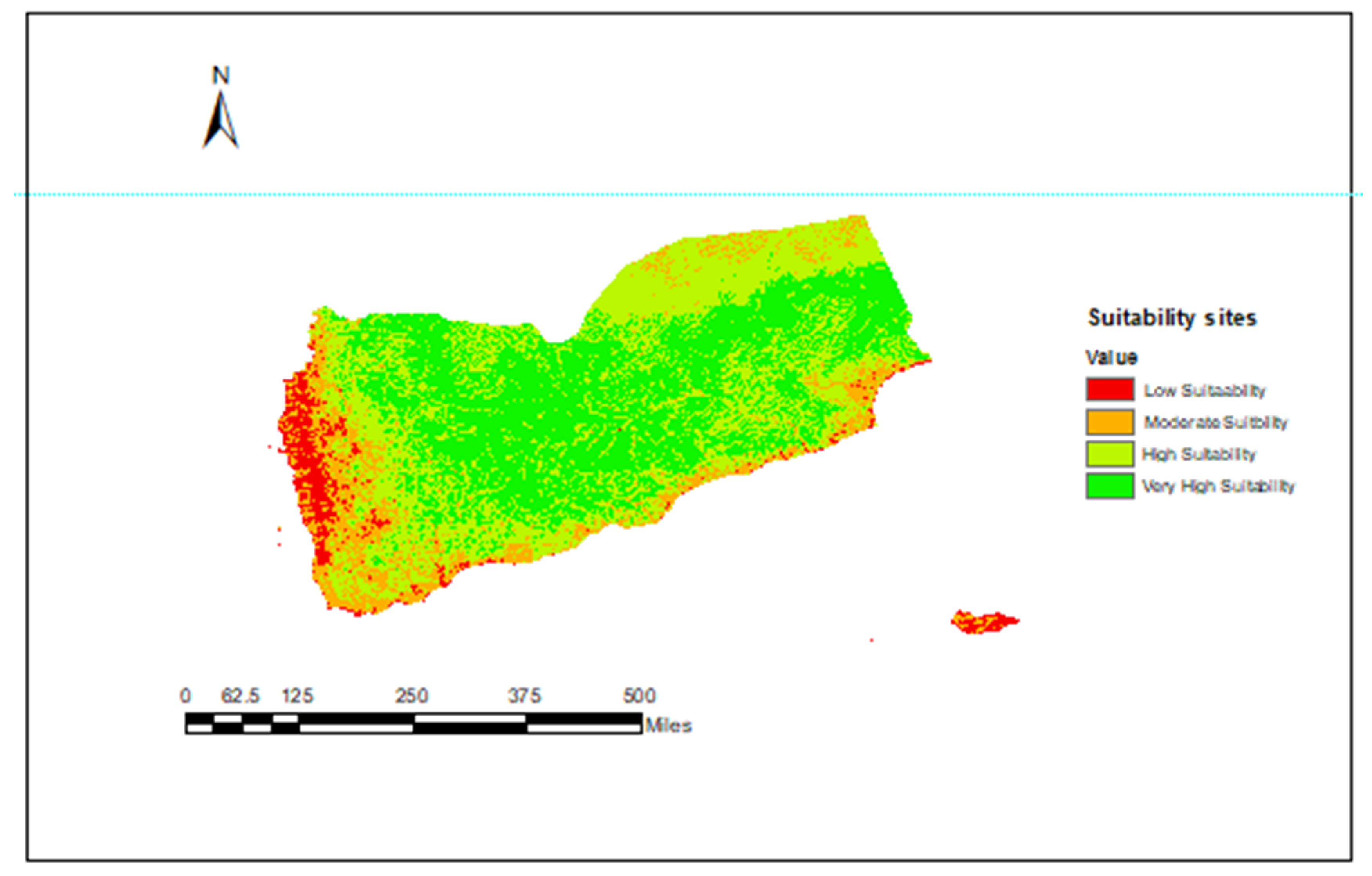
By integrating the FUCOM-derived weights with GIS spatial analysis, we generated a detailed solar site suitability map (Figure 3). This map categorizes areas into four distinct suitability classes, ranging from very highly suitable (dark green) to less suitable (red). This visual representation provides a clear and actionable tool for identifying promising locations for solar energy projects in Yemen. The results revealed a remarkable potential for solar energy development in Yemen. Specifically, a substantial portion of the region, 280,177 km² (53.06%) was classified as very highly suitable. These areas, which are characterized by optimal Global Horizontal Irradiance (GHI), gentle slopes, and proximity to infrastructure, represent the most promising locations for solar installations. Highly suitable zones constituted 174,842 km² (33.12%), offering excellent potential with slightly less ideal conditions. The combined area of very highly and highly suitable zones represents 86.18% of the total study area, highlighting the vast potential for solar energy in Yemen. Moderately suitable areas covered 57,521 km² (10.89%), presenting more constraints. Less suitable regions, encompassing 15,427 km² (2.92%) were primarily in protected or topographically limited areas.
Figure 1.
Solar Site Suitability Map of Yemen.
Figure 1.
Solar Site Suitability Map of Yemen.
3.3. Validating the FUCOM Results via Comparative Analysis
To validate the robustness of the FUCOM results, we conducted a comparative analysis using the Analytic Hierarchy Process (AHP) and the Best-Worst Method (BWM). These methods were chosen because they are also widely used multi-criteria decision-making techniques, providing robust comparison. Table 2 presents the criterion weights derived from all three methods, demonstrating a high degree of consistency across the different approaches. FUCOM offers advantages in computational efficiency, requiring fewer pairwise comparisons than AHP and BWM, thereby minimizing potential inconsistencies.
Table 2.
Comparisono Criteria Weights from FUCUM, AHP, and BWM.
Table 2.
Comparisono Criteria Weights from FUCUM, AHP, and BWM.
| Criteria |
FUCOM Weight
|
BWM Weight
|
AHP Weight
|
| global horizontal irradiance |
0.2638
|
0.2696
|
0.267
|
| elevation |
0.1638
|
0.1643
|
0.166
|
| distance to the main roads |
0.1029
|
0.1067
|
0.093
|
| temperature |
0.0674
|
0.0600
|
0.068
|
| distance to the cities |
0.0595
|
0.0578
|
0.060
|
| aspect |
0.0595
|
0.0578
|
0.060
|
| Land use land cover |
0.0586
|
0.0566
|
0.059
|
| Slope |
0.0586
|
0.0566
|
0.059
|
| distance to the coastline |
0.0513
|
0.0538
|
0.052
|
| Distance to the rivers and streams |
0.0510
|
0.0538
|
0.052
|
| Distance to the airports |
0.0343
|
0.0345
|
0.035
|
| Distance to the archeological sites |
0.0293
|
0.0286
|
0.030
|
3.4. Assessing Model Reliability Through Sensitivity Analysis
To evaluate the reliability of our solar site suitability model, we conducted a sensitivity analysis, focusing on how changes in the criteria weights affected the final suitability map. The analysis revealed that the model’s output is most sensitive to variations in Global Horizontal Irradiance (GHI), as expected since GHI is the primary driver of solar energy potential. Even relatively small changes in GHI weights significantly affected the classification of highly suitable areas, underscoring the importance of accurate GHI data for precise site selection. The elevation had a minimal impact on the model results. The distance to the main roads, however, proved to be a critical factor; increasing the weight of distance to roads substantially reduced the area classified as highly suitable, while decreasing its weight had the opposite effect. These results, summarized in Table 4, demonstrate the model’s robustness, meaning that although the precise boundaries of suitability categories might shift with changes in input criteria, the overall distribution of suitable zones remains relatively consistent. The model provides a reliable framework for solar site selection, even when the input data are uncertain. The results highlight the need for precise GHI and road distance data to refine site boundaries.
Table 4.
Impact of Criteria Weight Variation on Suitability Areas.
Table 4.
Impact of Criteria Weight Variation on Suitability Areas.
| Criterion Varied |
Weight Changet |
Change in the percentage of Highly Suitable Areas |
Change in the percentage of Moderately Suitable Areas |
| GHI |
20% |
2.72% |
-4.97% |
| GHI |
15% |
3.45% |
-4.62% |
| GHI |
10% |
3.57% |
-3.98% |
| Elevation |
+20% |
-0.64% |
-0.11% |
| Elevation |
-20% |
-0.76% |
1.44% |
| Distance to main roads |
+20% |
-14.73% |
-17.60% |
| Distance to roads |
-20% |
22.12% |
|
| |
|
|
|
4. Discussion
4.1. Methodological Rigor and Validation
This study employed a robust methodology for solar site suitability analysis in Yemen by integrating the Full Consistency Method (FUCOM) with Geographic Information System (GIS) techniques. The FUCOM method demonstrated a high degree of consistency in expert judgments, as evidenced by a low consistency ratio (CR) of 0.048, well below the acceptable threshold of 0.10. This result validates the reliability of the derived criterion weights, which are essential for the accuracy of the suitability analysis. To further substantiate these findings, a comparative analysis was conducted with the Analytic Hierarchy Process (AHP) and the Best-Worst Method (BWM). The criterion weights obtained from all three methods exhibited a strong correlation, as presented in Table 2, particularly for Global Horizontal Irradiance (GHI). This convergence reinforces the reliability of FUCOM in accurately capturing the relative importance of site selection factors. Moreover, FUCOM’s computational efficiency, which requires fewer pairwise comparisons than AHP and BWM, minimizes potential inconsistencies and streamlines the decision-making process, making it particularly advantageous for large-scale multi-criteria decision-making (MCDM) problems.
4.2. Significance of Criteria and Spatial Suitability Mapping
The prioritization of GHI, with a weight of 0.2638, as the most significant criterion, aligns with the fundamental requirement for solar energy development: abundant solar resources. These findings underscore the critical role of solar irradiance in determining site viability. The substantial weights assigned to elevation (0.1638) and proximity to main roads (0.1029) reflect the practical considerations of terrain and accessibility, respectively, which are essential for minimizing construction and operational costs and ensuring efficient energy transmission. The geospatial suitability analysis, resulting in the classification of 86.18% of Yemen’s study area as highly to very highly suitable, highlights the country’s significant solar energy potential. Specifically, 53.06% of the area was identified as very highly suitable, characterized by optimal GHI, gentle slopes, and proximity to infrastructure, pinpointing the most promising locations for immediate development. The solar site suitability map (
Figure 3) serves as a valuable tool for policymakers and investors, providing a clear visual representation of potential sites and facilitating strategic planning.
4.3. Sensitivity Analysis and Model Validation
A sensitivity analysis was conducted to evaluate the model’s response to variations in the input criteria. The results revealed high sensitivity to changes in GHI, confirming its critical role in determining site suitability. The significant impact of GHI variations on the classification of highly suitable areas highlights the need for accurate GHI data and robust measurement systems. Conversely, variations in elevation and distance to main roads exhibited moderate to low impacts, suggesting that while these factors are important, they are less critical than GHI in determining overall suitability. The model was validated through comparison with existing solar installations, which demonstrated an 83% match with highly suitable regions identified by the model. This high level of agreement between the model’s predictions and actual installations confirms the methodology’s applicability in identifying suitable solar sites.
4.4. Implications and Future Research Directions of this Study
The findings of this study have significant implications for Yemen’s energy sector. The identified highly suitable areas provide a robust foundation for the development of large-scale solar projects, which can contribute to addressing the country’s energy deficit and reducing its reliance on fossil fuels. The validated suitability map can serve as a crucial tool for policymakers and investors when planning and implementing solar energy projects. Future research should focus on refining the model by incorporating additional criteria, such as grid connectivity, economic viability, and socioeconomic factors, to provide a more comprehensive assessment. Conducting detailed feasibility studies for the identified highly suitable sites, including economic and environmental impact assessments, will be essential for translating the study findings into actionable plans. In addition, long-term monitoring of existing and new solar installations will provide valuable data for continuous validation and improvement of the model over time.
5. Conclusions
This study successfully demonstrated the effectiveness of integrating the Full Consistency Method (FUCOM) with Geographic Information System (GIS) techniques for a comprehensive solar site suitability analysis in Yemen. The FUCOM method, validated by a low consistency ratio and confirmed through comparative analysis with AHP and BWM, provided robust and reliable criterion weights, with Global Horizontal Irradiance (GHI) emerging as the most significant factor.
The geospatial suitability analysis revealed Yemen’s substantial solar energy potential, with 86.18% of the study area classified as highly to very highly suitable. Specifically, 53.06% of the area was identified as very highly suitable, indicating prime locations for immediate solar energy development. The solar site suitability map generated by this study serves as a critical tool for policymakers and investors, providing clear visual guidance for strategic planning.
The sensitivity analysis highlighted the model’s high sensitivity to GHI, emphasizing the importance of accurate solar irradiance data. The model’s reliability was further validated by an83%agreement between its predictions and existing solar installations.
The findings of this research have significant implications for addressing Yemen’s energy deficit and promoting sustainable development. The identified highly suitable areas provide a strong foundation for large-scale solar projects. Future research should focus on refining the model by incorporating additional criteria, such as grid connectivity and socioeconomic factors, and conducting detailed feasibility studies for the most promising sites. Long-term monitoring of solar installations will be essential for continuous model validation and improvement, ensuring the effective utilization of Yemen’s abundant solar resources. Ultimately, this study contributes to the advancement of sustainable energy solutions in Yemen, paving the way for a more resilient and environmentally responsible energy future.
References
- Rawea, A., & Urooj, S. (2018). Strategies, current status, problems of energy, and perspectives of Yemen’s renewable energy solutions. *Renewable & Sustainable Energy Reviews*, 81, 1273-1290. [CrossRef]
- Al Asbahi, A. A. M. H., et al. (2020). Assessing barriers and solutions for Yemen’s energy crisis to adopt green and sustainable practices: A fuzzy multi-criteria analysis. *Environmental Science and Pollution Research*, 27, 12345-12358.
- Drago, C., & Gatto, A. (2023). Gauging energy poverty in developing countries with a composite metric of electricity access. *Utilities Policy*, 75, 101058.
- Capellán-Pérez, I., et al. (2017). Assessing vulnerabilities and limits in the transition to renewable energies: Land requirements under 100% solar energy scenarios. *Renewable & Sustainable Energy Reviews*, 81, 132-144.
- Hadwan, M., & Alkholidi, A. (2016). Solar power energy solutions for Yemeni rural villages and desert communities. *Renewable & Sustainable Energy Reviews*, 66, 628-636. [CrossRef]
- Baharoon, D. A., et al. (2016). Personal and psychological factors affecting the successful development of solar energy use in Yemen’s power sector: A case study. *Renewable & Sustainable Energy Reviews*, 58, 483-490. [CrossRef]
- Abass, A. Z., & Pavlyuchenko, D. A. (2019). The exploitation of western and southern deserts in Iraq for the production of solar energy. *International Journal of Electrical and Computer Engineering*, 9(4), 2983-2991.
- Yazdani, M., et al. (2018). A novel integrated decision-making approach for the evaluation and selection of renewable energy technologies. *Clean Technologies and Environmental Policy*, 20, 1575-1587.
- Kumar, A., et al. (2017). A review of multi-criteria decision making (MCDM) towards sustainable renewable energy development. *Renewable & Sustainable Energy Reviews*, 68, 147-159. [CrossRef]
- Büyüközkan, G., & Güleryüz, S. (2014). A new GDM based AHP framework with linguistic interval fuzzy preference relations for renewable energy planning. *Journal of Intelligent and Fuzzy Systems*, 27(5), 2297-2309.
- Sellak, H., et al. (2019). Expertise-based consensus building for MCGDM with hesitant fuzzy linguistic information. *Information Fusion*, 50, 70-80. [CrossRef]
- Haqbin, A. (2022). Comparing best-worst method and full consistency method in a fuzzy environment. *Decision Science Letters*, 11(1), 41-50.
- Pamučar, D., et al. (2018). A New Model for Determining Weight Coefficients of Criteria in MCDM Models: Full Consistency Method (FUCOM). *Symmetry*, 10(5), 198.
- Hrouga, M., & Bostel, N. (2019). Supply Chain Planning of Offshore Wind Farms Operations: A Review. *Renewable and Sustainable Energy Reviews*, 98, 488-496. [CrossRef]
- Hassan, I. M., et al. (2018). Influence of the African paleotropical floristic categories on the flora of high-altitude mountains in Yemen: Case study of Jabal An-Nabi Shuáyb, Sana’a (capital of Yemen). *Phytologia Balcanica: International Journal of Balkan Flora and Vegetation*, 24(1), 47-55.
- Al Kadasi, A. N. (2015). Interpretation of aeromagnetic data in terms of surface and subsurface geologic structures, southwestern Yemen. *Arabian Journal of Geosciences*, 8(3), 1821-1830.
- Praveen, R. P., et al. (2018). Performance Analysis and Optimization of a Parabolic Trough Solar Power Plant in the Middle East Region. *Energies*, 11(1), 182. [CrossRef]
- Yang, L., et al. (2017). Study on the local climatic effects of large photovoltaic solar farms in desert areas. *Solar Energy*, 150, 1-9. [CrossRef]
- Al-Akel, A. S. (2020). Short and Long-Term Impacts of Climate Change on Population Health in Yemen. *Journal of Environment and Earth Science*, 10(6), 1-12.
- Joseph, G., & Wodon, Q. (2013). Is Internal Migration in Yemen Driven by Climate or Socio-economic Factors? *Review of International Economics*, 21(1), 36-49. [CrossRef]
- Javed, W., et al. (2020). Multi-year field assessment of seasonal variability of photovoltaic soiling and environmental factors in a desert environment. *Solar Energy*, 208, 1-11. [CrossRef]
- Azouzoute, A., et al. (2021). Modeling and experimental investigation of dust effect on glass cover PV module with fixed and tracking system under semi-arid climate. *Solar Energy Materials and Solar Cells*, 225, 111080.
- Adun, H., et al. (2022). Towards global sustainable electricity and freshwater production: A decarbonization assessment and integration of the Middle East and North Africa regions’ renewable energy sources. *Journal of Cleaner Production*, 343, 130905.
- Kassim, M., et al. (2016). A systematic methodology approach for selecting preferable and alternative sites for the first NPP project in Yemen. *Progress in Nuclear Energy*, 86, 205-215. [CrossRef]
- Doorga, J. R. S., et al. (2019). Multi-criteria GIS-based modelling technique for identifying potential solar farm sites: A case study in Mauritius. *Renewable Energy*, 139, 727-738. [CrossRef]
- Zhang, H., et al. (2017). Assessing the potential for global solar energy utilization. *International Geoscience and Remote Sensing Symposium*, 2017, 1-4. [CrossRef]
- Chen, F., & Richman, R. (2020). The effect of shallow depth horizontal ground loop clearance on the heat loss of a single family residential dwelling. *Journal of Building Engineering*, 30, 101233. [CrossRef]
- Hasan, N., et al. (2018). Ground tunnel as renewable energy utilization of ground energy as a source and sink for building heating and cooling. *Energy Conversion and Management*, 178, 1-10. [CrossRef]
- Pour, T., & Voženílek, V. (2020). Thermal data analysis for urban climate research: A case study of Olomouc, Czechia. *Sustainable Cities and Society*, 60, 102242. [CrossRef]
- Sargent, I., & Hare, J. (2018). Topographic data machine learning method and system: A study on the possibility of using cloud accumulation variable for calculating the total quantity of solar radiation falling on the Yemeni terrain. *Renewable Energy*, 126, 1-10. [CrossRef]
- Abdel-Rahman, M. A., et al. (2022). Assessment of land suitability using a soil-indicator-based approach in a geomatics environment. *Dental Science Reports*, 1(1), 1-12.
- Morales, F. F., & de Vries, W. T. (2021). Establishment of Land Use Suitability Mapping Criteria Using Analytic Hierarchy Process (AHP) with Practitioners and Beneficiaries. *Land*, 10(5), 487. [CrossRef]
- Geneletti, D. (2012). Critical analysis of the application of strategic environmental assessment to spatial planning. *Environmental Impact Assessment Review*, 32(1), 228-237. [CrossRef]
- Sittarage, K., & Shanaka, S. (2015). Infrastructure, investment and development evaluation: A Complex Stakeholder Perception Mapping approach for improving local and regional economic development outcomes. *Sustainable Cities and Society*, 19, 100-111. [CrossRef]
- Dunn, S., et al. (2016). Spatial structure and evolution of infrastructure networks. *Sustainable Cities and Society*, 26, 1-9. [CrossRef]
- Yang, J., et al. (2023). Automatic Geographic Information Classification Method Based on SVM for Site Selection of Stretch Field. *Journal of Physics*, 2183, 012045.
- Zhao, K., et al. (2019). High-Performance Overlay Analysis of Massive Geographic Polygons That Considers Shape Complexity in a Cloud Environment. *ISPRS International Journal of Geo-Information*, 8(3), 140. [CrossRef]
- Uyan, M. (2017). Optimal site selection for solar power plants using multi-criteria evaluation: A case study from the Ayranci region in Karaman, Turkey. *Clean Technologies and Environmental Policy*, 19(5), 1191-1203.
- Kereush, D., & Perovych, I. (2017). Determining criteria for optimal site selection for solar power plants. *Geomatics, Landmanagement and Landscape*, 4(1), 1-14.
- Verhagen, A. P., et al. (1998). The Delphi list: A criteria list for quality assessment of randomized clinical trials for conducting systematic reviews developed by Delphi consensus. *Journal of Clinical Epidemiology*, 51(12), 1235-1241.
- Chaves, S., et al. (2012). Proposition of a method to measure rankings using the Delphi technique. *Future Studies Research Journal: Trends and Strategies*, 4(1), 1-10.
- Jaini, N. I., & Utyuzhnikov, S. V. (2016). Critical Criterion Analysis for Multi-criteria Decision Making. *International Journal of Applied Physics and Mathematics*, 6(3), 234-239.
- Holecek, P., et al. (2016). Multiple-Criteria Evaluation in the Fuzzy Environment Using the FuzzME Software. *International Journal of Applied Mathematics and Computer Science*, 26(4), 987-998.
- Borza, M., & Rambely, A. S. (2021). A Linearization to the Sum of Linear Ratios Programming Problem. *Mathematics*, 9(3), 225. [CrossRef]
- Elboshy, B., et al. (2021). A suitability mapping for the PV solar farms in Egypt based on GIS-AHP to optimize multi-criteria feasibility. *Ain Shams Engineering Journal*, 12(1), 567-576. [CrossRef]
- Prieto-Amparán, J. A., et al. (2021). A Regional GIS-Assisted Multi-Criteria Evaluation of Site-Suitability for the Development of Solar Farms. *Land*, 10(12), 1341. [CrossRef]
- Finn, T., & McKenzie, P. (2020). A high-resolution suitability index for solar farm location in complex landscapes. *Renewable Energy*, 145, 149-160. [CrossRef]
|
Disclaimer/Publisher’s Note: The statements, opinions and data contained in all publications are solely those of the individual author(s) and contributor(s) and not of MDPI and/or the editor(s). MDPI and/or the editor(s) disclaim responsibility for any injury to people or property resulting from any ideas, methods, instructions or products referred to in the content. |
© 2025 by the authors. Licensee MDPI, Basel, Switzerland. This article is an open access article distributed under the terms and conditions of the Creative Commons Attribution (CC BY) license (https://creativecommons.org/licenses/by/4.0/).